Panama is a country located in Caribbean, bordering both the Caribbean Sea and the Pacific Ocean, between Colombia and Costa Rica. Panama is located on the narrow and low Isthmus of Panama.

Dacite is a volcanic rock formed by rapid solidification of lava that is high in silica and low in alkali metal oxides. It has a fine-grained (aphanitic) to porphyritic texture and is intermediate in composition between andesite and rhyolite. It is composed predominantly of plagioclase feldspar and quartz.

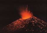
A volcanic arc is a belt of volcanoes formed above a subducting oceanic tectonic plate, with the belt arranged in an arc shape as seen from above. Volcanic arcs typically parallel an oceanic trench, with the arc located further from the subducting plate than the trench. The oceanic plate is saturated with water, mostly in the form of hydrous minerals such as micas, amphiboles, and serpentines. As the oceanic plate is subducted, it is subjected to increasing pressure and temperature with increasing depth. The heat and pressure break down the hydrous minerals in the plate, releasing water into the overlying mantle. Volatiles such as water drastically lower the melting point of the mantle, causing some of the mantle to melt and form magma at depth under the overriding plate. The magma ascends to form an arc of volcanoes parallel to the subduction zone.
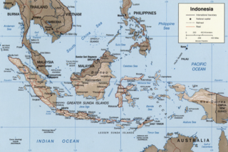
The Sunda Arc is a volcanic arc that produced the volcanoes that form the topographic spine of the islands of Sumatra, Nusa Tenggara, Java, the Sunda Strait, and the Lesser Sunda Islands. The Sunda Arc begins at Sumatra and ends at Flores, and is adjacent to the Banda Arc. The Sunda Arc is formed via the subduction of the Indo-Australian Plate beneath the Sunda and Burma plates at a velocity of 63–70 mm/year.

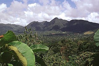
The Volcán Barú is an active stratovolcano and the tallest mountain in Panama, at 3,475 metres (11,401 ft) high. It lies about 35 km (22 mi) off the border of Costa Rica. It is also the twelfth highest peak in Central America.

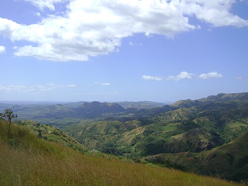
The Central American Volcanic Arc is a chain of volcanoes which extends parallel to the Pacific coastline of the Central American Isthmus, from Mexico to Panama. This volcanic arc, which has a length of 1,100 kilometers (680 mi) is formed by an active subduction zone, with the Cocos plate subducting underneath the Caribbean plate, the North American plate and the Panama plate. Volcanic activity is recorded in the Central American region since the Permian. Numerous volcanoes are spread throughout various Central American countries; many have been active in the geologic past, varying in intensity of their activity according to different factors.
Cerro Macá is a stratovolcano located to the north of the Aisén Fjord and to the east of the Moraleda Channel, in the Aysén del General Carlos Ibáñez del Campo Region of Chile. This glacier-covered volcano lies along the regional Liquiñe-Ofqui Fault Zone.
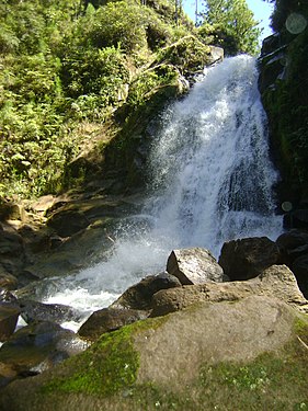
El Valle is a stratovolcano in central Panama and is the easternmost volcano along the Central American Volcanic Arc which has been formed by the subduction of the Nazca Plate below Central America. Some time prior to 200,000 years ago, the volcano underwent a huge eruption event that caused the top of the volcano to collapse into the empty magma chamber below forming a large caldera. Several lava domes have developed inside the caldera since the collapse—forming Cerro Pajita, Cerro Gaital and Cerro Caracoral peaks. Prior to research in the early 1990s, it was thought that no active volcanism existed within Panama. But radioactive dates from El Valle show that the volcano last erupted as recently as 200,000 years ago.
Adakites are volcanic rocks of intermediate to felsic composition that have geochemical characteristics of magma originally thought to have formed by partial melting of altered basalt that is subducted below volcanic arcs. Most magmas derived in subduction zones come from the mantle above the subducting plate when hydrous fluids are released from minerals that break down in the metamorphosed basalt, rise into the mantle, and initiate partial melting. However, Defant and Drummond recognized that when young oceanic crust is subducted, adakites are typically produced in the arc. They postulated that when young oceanic crust is subducted it is "warmer" than crust that is typically subducted. The warmer crust enables melting of the metamorphosed subducted basalt rather than the mantle above. Experimental work by several researchers has verified the geochemical characteristics of "slab melts" and the contention that melts can form from young and therefore warmer crust in subduction zones.
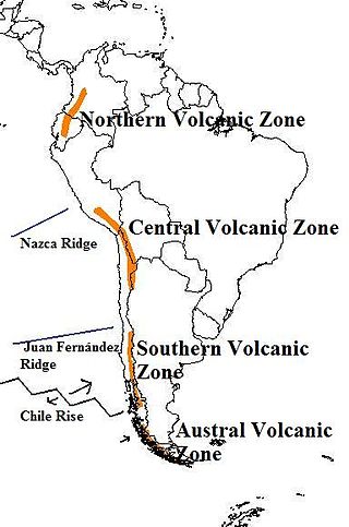
The Andean Volcanic Belt is a major volcanic belt along the Andean cordillera in Argentina, Bolivia, Chile, Colombia, Ecuador, and Peru. It is formed as a result of subduction of the Nazca plate and Antarctic plate underneath the South American plate. The belt is subdivided into four main volcanic zones which are separated by volcanic gaps. The volcanoes of the belt are diverse in terms of activity style, products, and morphology. While some differences can be explained by which volcanic zone a volcano belongs to, there are significant differences within volcanic zones and even between neighboring volcanoes. Despite being a type location for calc-alkalic and subduction volcanism, the Andean Volcanic Belt has a broad range of volcano-tectonic settings, as it has rift systems and extensional zones, transpressional faults, subduction of mid-ocean ridges and seamount chains as well as a large range of crustal thicknesses and magma ascent paths and different amounts of crustal assimilations.

Cay is a stratovolcano in the South Volcanic Zone of the Andes in Aysén del General Carlos Ibáñez del Campo Region, Chile. The volcano is located 15 km northeast of the larger Maca Volcano and about 230 km of the Chile Trench at the intersection of NW-SE and NE-SW faults of the Liquiñe-Ofqui Fault Zone.

The Luzon Volcanic Arc is a chain of volcanoes in a north–south line across the Luzon Strait from Taiwan to Luzon. The name "Luzon Volcanic Arc" was first proposed by Carl Bowin et al. to describe a series of Miocene to recent volcanoes due to eastward subduction along the Manila Trench for approximately 1,200 km from the Coastal Range in Taiwan south to southern Mindoro in the Philippines. Islands that form part of the arc are the Eastern Coastal Range of Taiwan, Green Island, Taiwan, Orchid Island, Kaotai Rock, Mavudis or Y'ami Island, Mabudis, Siayan Island, Itbayat Island, Diogo Island, Batan Island, Unnamed volcano Ibuhos, Sabtang Island, Babuyan, Didicas, and Camiguin de Babuyanes. At the south end it terminates on Luzon. The geochemistry of a number of volcanoes along the arc have been measured. There are five distinct geochemical domains within the arc. The geochemistry of the segments verified that the volcanoes are all subduction related. Isotopes and trace elements show unique geochemical characteristics in the north. Geochemical variations northward were due to the subduction of sediments derived from the erosion of continental crust from China and Taiwan.
Jaraguay volcanic field is a volcanic field in northern Baja California, Mexico.
Shahsavaran is a volcanic field in Iran. It covers an ellipse shaped area west of Bazman volcano. The field has erupted lava cones and lava flows, along with some explosive volcanic activity especially in the eastern part of the field. Volcanic rocks in the field are dominated by andesite, with subordinate basalt, dacite and rhyodacite. The volcanism has lasted from 12 million years ago to recent times, the 2010 Hosseinabad earthquake took place within the field but seems to be unrelated to volcanic activity.

La Reforma is a Plio-Pleistocene caldera on the Baja California Peninsula in Mexico. It is part of eleven volcanoes in Baja California, which formed with the Gulf of California during the Miocene, about ten million years ago. Previously, a volcanic arc had existed on the peninsula. The caldera's basement consists of granites and monzonites, formed between the Cretaceous and the Middle Miocene.
Fueguino is a volcanic field in Chile. The southernmost volcano in the Andes, it lies on Tierra del Fuego's Cook Island and also extends over nearby Londonderry Island. The field is formed by lava domes, pyroclastic cones, and a crater lake.
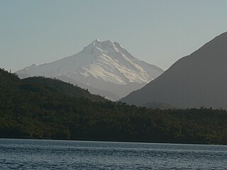
Río Murta is a volcano in Chile.
San Borja volcanic field is a volcanic field in Baja California, northeast of the Vizcaino Peninsula. It is formed by a plateau of lava flows and a number of scoria cones. The field started erupting over twelve million years ago and has endured several changes in regional tectonics.
The geology of Costa Rica is part of the Panama Microplate, which is slowly moving north relative to the stable Caribbean Plate.

Cerro Overo is a volcanic crater in Chile. It lies at the foot of Chiliques volcano and close to Laguna Lejía, over ignimbrites of Pliocene age erupted by the La Pacana volcano. It is 480 by 580 metres wide and 72 metres (236 ft) deep and formed through combined explosive-effusive eruptions. The lavas are of lower crustal provenience and are among the least silicic in the region.