Volcán Tajumulco

Last updated • 1 min readFrom Wikipedia, The Free Encyclopedia
Volcán Tajumulco
Tajumulco Volcano.JPG
Crater of the Volcán Tajumulco
Highest point
Elevation 4,203 m (13,789 ft)
Prominence 3,980 m (13,060 ft)
Listing
Coordinates 15°02′37″N91°54′12″W / 15.043685°N 91.903308°W / 15.043685; -91.903308
Geography
Relief map of Guatemala.jpg
Red triangle with thick white border.svg
Volcán Tajumulco
Location in Guatemala
Location San Marcos, Guatemala
Parent range Sierra Madre
Geology
Mountain type Stratovolcano
Volcanic arc/belt Central America Volcanic Arc
Last eruption Unknown

Volcán Tajumulco is a large stratovolcano in the department of San Marcos in western Guatemala. It is the highest mountain in Central America at 4,203 metres (13,789 ft). It is part of the mountain range of the Sierra Madre de Chiapas, which begins in Mexico's southernmost state of Chiapas. [1]

Contents

Description

Tajumulco is composed of andesitic-dacitic lavas on the top of a large escarpment of uncertain origin. It has two summits, one of which has a crater 50–70 metres (160–230 ft) wide. A lava flow from the north-western summit descends into a steep valley on the same side of the volcano. [2]

The volcano's eruptive history is unclear and the date of its last eruption unknown. Reports from the 18th and early 19th century claim to record eruptions but these are considered unlikely. [2]

The region around Tajumulco is relatively sparsely populated. [2] The nearest town is San Marcos, located 14 kilometres (8.7 mi) to the south-east. [1] Although it is infrequently visited, [2] the volcano can be climbed in about five hours from the hamlet of Tuichán. Views are variable as the area is frequently covered in mist and cloud, with conditions at their least favorable between April and September. [3]

See also

Notes

  1. 1 2 "Tajumulco Volcano." Britannica Library, Encyclopædia Britannica, 27 February 2012. Accessed 22 April 2017
  2. 1 2 3 4 "Tajumulco". Smithsonian Institution National Museum of Natural History Global Volcanism Program. Retrieved 22 April 2017.
  3. Stewart, Iain (2009). The Rough Guide to Guatemala. Rough Guides Limited. p. 477. ISBN   978-1-84836-017-4.

Related Research Articles

<span class="mw-page-title-main">Pichincha (volcano)</span> Volcano in north-central Ecuador

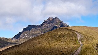
Pichincha is a stratovolcano in Ecuador. The capital Quito wraps around its eastern slopes.

<span class="mw-page-title-main">Öræfajökull</span> Volcano in south-eastern Iceland

Öræfajökull is an ice-covered volcano in south-east Iceland. The largest active volcano and the highest peak in Iceland at 2,110 metres (6,920 ft), it lies within the Vatnajökull National Park and is covered by part of the glacier.

<span class="mw-page-title-main">San Marcos Department</span> Department of Guatemala

San Marcos is a department in northwestern Guatemala, on the Pacific Ocean and along the western Guatemala-Mexico border.

<span class="mw-page-title-main">Santa María (volcano)</span> Active volcano in Quetzaltenango Department, Guatemala

Santa María Volcano is a large active volcano in the western highlands of Guatemala, in the Quetzaltenango Department near the city of Quetzaltenango. It is part of the mountain range of the Sierra Madre.

<span class="mw-page-title-main">Pacaya</span> Mountain and national park in Guatemala

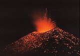
Pacaya is an active complex volcano in Guatemala, which first erupted approximately 23,000 years ago and has erupted at least 23 times since the Spanish conquest of Guatemala. It rises to an elevation of 2,552 metres (8,373 ft). After being dormant for over 70 years, it began erupting vigorously in 1961 and has been erupting frequently since then. Much of its activity is Strombolian, but occasionally Plinian eruptions also occur, sometimes showering the area of the nearby Departments with ash.

<span class="mw-page-title-main">Irazú Volcano</span> Active volcano in Costa Rica

The Irazú Volcano is an active volcano in Costa Rica, situated in the Cordillera Central close to the city of Cartago.

<span class="mw-page-title-main">Acatenango</span> Stratovolcano in Guatemala

Acatenango is a stratovolcano in Guatemala, close to the city of Antigua. It is part of the mountain range of the Sierra Madre. The volcano has two peaks, Pico Mayor and Yepocapa which is also known as Tres Hermanas. Acatenango is joined with Volcán de Fuego and collectively the volcano complex is known as La Horqueta.

<span class="mw-page-title-main">Volcán de Fuego</span> Volcano in Guatemala

Volcán de Fuego or Chi Q'aq' is an active stratovolcano in Guatemala, on the borders of Chimaltenango, Escuintla and Sacatepéquez departments.

<span class="mw-page-title-main">Volcán San Pedro</span> Volcano in Guatemala

Volcán San Pedro is a 3,020-metre (9,908 ft) stratovolcano on the shores of Lago de Atitlán, in the Sololá Department of southern Guatemala. It is part of the mountain range of the Sierra Madre.

<span class="mw-page-title-main">Mount Chiginagak</span> Active volcano in the U.S. state of Alaska

Mount Chiginagak is a stratovolcano on the Alaska Peninsula, located about 15 km northwest of Chiginagak Bay.

<span class="mw-page-title-main">Sierra Madre de Chiapas</span> Mountain range in Central America

The Sierra Madre is a major mountain range in Central America. It is known as the Sierra Madre de Chiapas in Mexico. It crosses El Salvador, Guatemala, Mexico and Honduras. The Sierra Madre is part of the American Cordillera, a chain of mountain ranges that consists of an almost continuous sequence of mountain ranges that form the western "backbone" of North America, Central America, and South America.

<span class="mw-page-title-main">Isluga</span> Mountain in Chile

Isluga is a stratovolcano located in Colchane, 7 kilometres (4.3 mi) west of the Chile-Bolivia border and at the west end of a group of volcanoes lined up in an east-west direction, which also includes the volcanoes Cabaray and Tata Sabaya. Isluga has an elongated summit area and lies within the borders of Volcán Isluga National Park in Chile's Tarapacá Region.

<span class="mw-page-title-main">Volcán Tacaná</span> Stratovolcano in northern Guatemala

The volcano Tacaná is the second highest peak in Central America at 4,060 metres (13,320 ft), located in the Sierra Madre de Chiapas of northern Guatemala and southern Mexico. It is also known in Mexico as Volcán Tacina.

<span class="mw-page-title-main">Volcán Putana</span> Mountain in Chile

Volcán Putana, sometimes referred to as Jorqencal or Machuca, is a stratovolcano located In the Central Volcanic Zone (CVZ) of the Andes on the border between Bolivia and Chile and close to the Sairecabur volcanic complex. Its summit is 5,884 metres (19,304 ft) above sea level and contains a summit crater with two smaller craters nested within it. Beneath the summit, the volcano features a number of lava domes and lava flows, some of which originated in flank vents.

<span class="mw-page-title-main">Volcán Siete Orejas</span>

Volcán Siete Orejas is a stratovolcano in Guatemala located within the Quetzaltenango Department, in the municipalities of Quetzaltenango, Concepción Chiquirichapa, La Esperanza, and San Martin Sacatepequez. It is in the Sierra Madre de Chiapas.

References

  • Encyclopædia Britannica Online. "Tajumulco Volcano". Encyclopædia Britannica. Encyclopædia Britannica Online. Retrieved 2011-01-14.
  • INSIVUMEH. "Volcanes de Guatemala" (in Spanish). Guatemala City: Instituto Nacional de Sismología, Vulcanología, Meteorologíá e Hidrologíá (INSIVUMEH) - Ministerio de Comunicaciones, Infraestructura y Vivienda. Retrieved 2011-01-14.