Barbeau Peak is a mountain in Qikiqtaaluk, Nunavut, Canada. Located on Ellesmere Island within Quttinirpaaq National Park, it is the highest mountain in Nunavut and the Canadian Arctic. The mountain was named in 1969 after Marius Barbeau, a Canadian anthropologist whose research into First Nations and Inuit cultures gained him international acclaim.

Southampton Island is a large island at the entrance to Hudson Bay at Foxe Basin. One of the larger members of the Arctic Archipelago, Southampton Island is part of the Kivalliq Region in Nunavut, Canada. The area of the island is stated as 41,214 km2 (15,913 sq mi) by Statistics Canada. It is the 34th largest island in the world and Canada's ninth largest island. The only settlement on Southampton Island is Coral Harbour, called Salliq in Inuktitut.

Melville Peninsula is a large peninsula in the Canadian Arctic north of Hudson Bay. To the east is Foxe Basin and to the west the Gulf of Boothia. To the north the Fury and Hecla Strait separates it from Baffin Island. To the south Repulse Bay and Frozen Strait separate it from Southampton Island at the north end of Hudson Bay. On the southwest it is connected to the mainland by the Rae Isthmus, named after the Arctic explorer John Rae.
Erik Mathiassen Enge was a Norwegian politician for the Free-minded Liberal Party and later the Agrarian Party. He served as Minister of Agriculture from 1912 to 1913. From 1927 to 1930, he was the leader of the Agrarian Party. Enge was a farmer by profession.

The Journals of Knud Rasmussen is a 2006 Canadian-Danish film directed by Zacharias Kunuk and Norman Cohn. The film is about the pressures on traditional Inuit shamanistic beliefs as documented by Knud Rasmussen during his travels across the Canadian Arctic in the 1920s.

Qiajivik Mountain is a mountain in Qikiqtaaluk, Nunavut, Canada. Located in northeastern Baffin Island, it is part of the Baffin Mountains. At 1,965 m (6,447 ft) Qiajivik is the highest mountain in northern Baffin Island and with a topographic prominence of 1,787 m (5,863 ft) it is one of Canada's 142 ultra-prominent peaks.

Mount Odin is a mountain in Qikiqtaaluk, Nunavut, Canada. It is located in Auyuittuq National Park along the Akshayuk Pass, 46 km (29 mi) north of Pangnirtung and south of Mount Asgard. Mount Odin is the highest mountain on Baffin Island.
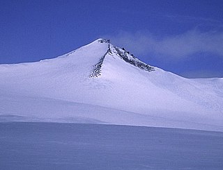
Outlook Peak is a mountain in Qikiqtaaluk, Nunavut, Canada, located on the southwestern edge of the Muller Icecap. It is the highest mountain of the Princess Margaret Range at 2,210 m (7,251 ft), the highest on Axel Heiberg Island, and the fourth highest in Nunavut.
The Inglefield Mountains are a mountain range in southeastern Ellesmere Island, Nunavut, Canada. The mountain range is mostly covered by ice fields, with granitic nunataks reaching a height of 1,500 m (4,921 ft) above sea level. Rocky cliffs border the coastal areas. Like most other mountain ranges in the Canadian Arctic, the Inglefield Mountains are part of the Arctic Cordillera.
Commonwealth Mountain is a mountain on Ellesmere Island, Nunavut, Canada. It lies in western Quttinirpaaq National Park, which is the most northerly extent of Canada, and is the second most northerly park on Earth after Northeast Greenland National Park.
White Crown Mountain is a mountain in the Princess Margaret Range on Axel Heiberg Island, Nunavut, Canada. It is located on the southwestern edge of the Muller Icecap and is surrounded by glaciers.
The Precipitous Mountains are a mountain range on northern Baffin Island, Nunavut, Canada. It lies in, or near, Sirmilik National Park and is a subrange of the Arctic Cordillera.

The Everett Mountains are a mountain range located at Frobisher Bay on southern Baffin Island, Nunavut, Canada. Nunavut's capital city Iqaluit is protected by the Everett Mountains. The mountain range is a subrange of the Arctic Cordillera.
Angilaaq Mountain is a mountain in Qikiqtaaluk Region, Nunavut, Canada. It is located 62 km (39 mi) north of Pond Inlet. It is the highest mountain on Bylot Island and lies in the Byam Martin Mountains, which is a northern extension of the Baffin Mountains.
Kisimngiuqtuq Peak is a mountain in Qikiqtaaluk, Nunavut, Canada. It is associated with the Baffin Mountains on Baffin Island. It is the tenth highest peak in Nunavut and the eleventh highest peak in Nunavut by topographic prominence.
Ukpik Peak is a mountain associated with the Baffin Mountains on Baffin Island, Nunavut, Canada.
Bastille Peak is a mountain located 74 km (46 mi) north of Pangnirtung, Baffin Island, Nunavut, Canada. It is associated with the Baffin Mountains which in turn form part of the Arctic Cordillera mountain system.
Angna Mountain is a mountain located on Baffin Island, Nunavut, Canada. It is associated with the Baffin Mountains which in turn form part of the Arctic Cordillera mountain system.
The Paint Hills Islands are located in James Bay, a part of the Qikiqtaaluk Region, in the Canadian territory of Nunavut. They are southwest of Wemindji, Quebec, a Cree community on Paint Hills Bay, and northeast of Solomons Temple Islands.

