
Costa Rica is located on the Central American Isthmus, surrounding the point 10° north of the equator and 84° west of the prime meridian. It has 212 km of Caribbean Sea coastline and 1,016 on the North Pacific Ocean.

Panama is a country located in Caribbean, bordering both the Caribbean Sea and the Pacific Ocean, between Colombia and Costa Rica. Panama is located on the narrow and low Isthmus of Panama.

The Nattai National Park is a protected area located in the Macarthur and Southern Highlands regions of New South Wales, Australia. The 48,984-hectare (121,040-acre) area is situated approximately 150 kilometres (93 mi) southwest of the Sydney central business district and primarily encompasses the valley of the Nattai River, which is surrounded by sandstone cliffs. Part of the Southern Highlands Shale Forest and Woodland, the park is covered in dry sclerophyll (hard-leafed) forest – mostly eucalypt, and has frequent forest fires. As of May 2024, the park has no facilities.

Cerro Chirripó is the highest mountain in Costa Rica, with an elevation of 3,821 meters. It is part of the Cordillera de Talamanca, and the range's highest point. It is located in Chirripó National Park and is noted for its ecological wealth. The mountain was named "Chirripo", meaning "land of eternal waters", by indigenous Costa Ricans because there are many lakes and streams around the mountain. The high peaks in Chirripó National Park and La Amistad International Park host important areas of Talamancan montane forest and Costa Rican Páramo with high endemism and extremely high biodiversity. The peaks of these mountains constitute sky islands for many species of plants and animals. Snow has not fallen on the peak in the past 100 years or so, according to the University of Costa Rica, but hail is sometimes reported.
Darién National Park is a World Heritage Site in Panama. It is about 325 kilometers (202 mi) from Panama City, is the most extensive of all national parks of Panama, and is one of the most important World Heritage Sites in Central America.
Braulio Carrillo National Park is a national park in Heredia Province, Cartago Province, Limón Province and San José Province, in central Costa Rica. It is part of the Central Conservation Area.

Tapantí - Cerro de la Muerte Massif National Park,, is a national park in the Central Conservation Area of Costa Rica located on the edge of the Talamanca Range, near Cartago. It protects forests to the north of Chirripó National Park, and also contains part of the Orosí River. The area known as Cerro de la Muerte Massif was added to the park on January 14, 2000.

Orosi is a district of the Paraíso canton, in the Cartago province of Costa Rica.

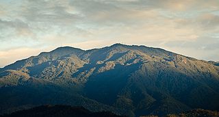
The Cordillera de Talamanca is a mountain range that lies in the southeast half of Costa Rica and the far west of Panama. Much of the range and the area around it is included in La Amistad International Park, which also is shared between the two countries.
Chirripó National Park is a national park of Costa Rica, encompassing parts of three provinces: San José, Limón and Cartago. It was established in 1975.

Barbilla National Park is a national park in the Caribbean La Amistad Conservation Area of Costa Rica located on the eastern slopes of the Cordillera de Talamanca. It protects forests as well as Laguna Ayil and Cerro Tigre and the Dantas River watershed, covering parts of both Cartago and Limón Provinces. It was initially established in 1982.
Cerro de la Muerte is a mountain peak of a massif in Costa Rica, it is located within the Tapantí — Cerro de la Muerte Massif National Park, and is the highest point on the Pan-American Highway.
Talamanca is a canton in the Limón province of Costa Rica. The head city is Bribri, located in Bratsi district.

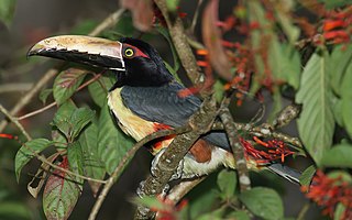
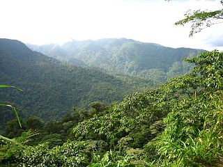
The Talamancan montane forests ecoregion, in the tropical moist broadleaf forest biome, are in montane Costa Rica and western Panama in Central America.
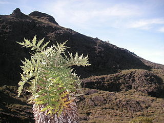
The Costa Rican páramo, also known as the Talamanca páramo, is a natural region of montane grassland and shrubland of Costa Rica and western Panama.
Isthmohyla calypsa is a species of frogs in the family Hylidae. It is known from the southern Cordillera de Talamanca in Costa Rica, Cerro Pando in Costa Rica and Panama, and the Pacific slope in southwestern Panama. It appears to now be extirpated from Costa Rica. Prior to its description in 1996, this species was confused with Isthmohyla lancasteri, a species now known from lower altitudes only.
San Gerardo de Rivas is a small village high up in the valley of the Chirripó Pacífico river in the Talamanca Mountains of south central Costa Rica. It is 20 kilometers northeast of San Isidro de El General, which is the second-largest city in San José Province.

The La Amistad International Park, or in Spanish Parque Internacional La Amistad, formerly the La Amistad National Park, is a transboundary protected area in Latin America, management of which is shared between Costa Rica and Panama, following a recommendation by UNESCO after the park's inclusion in the World Heritage Site list in 1983. The park and surrounding biosphere reserve is one of the most outstanding conservation areas in Central America, preserving a major tract of tropical forest wilderness. It is known for its extraordinary biodiversity and endemism.
