Cerro Pico Alto

Last updated

The Cerro Pico Alto is the third highest mountain of the Cerros de Escazú, Costa Rica with 2,428 m (7,966 ft). [1] Pico Alto means high peak.

Cerros de Escazú mountains in Costa Rica

The Cerros de Escazú is a mountain range in San José Province, central Costa Rica.

Costa Rica country in Central America

Costa Rica, officially the Republic of Costa Rica, is a country in Central America, bordered by Nicaragua to the north, the Caribbean Sea to the northeast, Panama to the southeast, the Pacific Ocean to the southwest, and Ecuador to the south of Cocos Island. It has a population of around 5 million in a land area of 51,060 square kilometers. An estimated 333,980 people live in the capital and largest city, San José with around 2 million people in the surrounding metropolitan area.

See also

The Cerro Rabo de Mico is the highest mountain of the Cerros de Escazú, Costa Rica with 2,428 m (7,966 ft). The peak is accessible by trails from Escazu as well as Aserri, through the trail that leads past la Piedra de Aserri. Rabo de mico means literally 'monkey tail' although this denomination probably comes from a tree fern colloquially named likewise.

Cerro Cedral mountain in Costa Rica

The Cerro Cedral is the second highest mountain of the Cerros de Escazú, Costa Rica with 2,420 m (7,940 ft). Cedral means 'cedar forest' referring to an endangered tree species locally known as Cedro Dulce, which occurs there.

The Cerro Pico Blanco is the second highest mountain of the Cerros de Escazú, Costa Rica, with a summit elevation of 2,428 m (7,966 ft). Pico Blanco means literally 'white peak', making reference of the rocky outcropping close to its highest point, that looks light gray from the Central Valley.

Related Research Articles

"Huatusco de Chicuellar", is a city in the Mexican state of Veracruz, on the Xalapa–Mexico City railroad that was founded by Italian immigrants. It is bordered by Calcahualco, the state of Puebla, Ixhuatlán del Café and Federal Highway 180.

Sistema Central mountain range

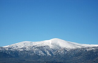
The Central System, Spanish and Portuguese: Sistema Central, is one of the main systems of mountain ranges in the Iberian Peninsula. 2,592 m high Pico Almanzor is its highest summit.

Cordillera Occidental (Colombia) western branch of the Andes in Colombia

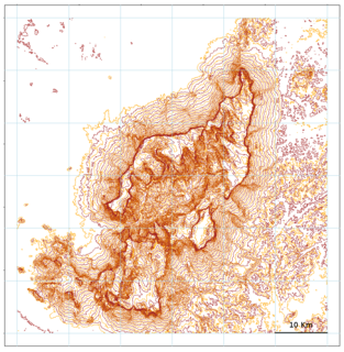
The Cordillera Occidental is the lowest in elevation of the three branches of the Colombian Andes. The average altitude is 2,000 m (6,600 ft) and the highest peak is Cerro Tatamá at 4,100 m (13,500 ft). The range extends from south to north dividing from the Colombian Massif in Nariño Department, passes north through Cauca, Valle del Cauca, Risaralda, Chocó, and Caldas Departments to the Paramillo Massif in Antioquia and Córdoba Departments. From this massif the range divides further to form the Serranías de Ayapel, San Jerónimo and Abibe. Only to recede into the Caribbean plain and the Sinú River valley.

La Misión, Hidalgo Municipality and town in Hidalgo, Mexico

La Misión is a town and one of the 84 municipalities of Hidalgo, in central-eastern Mexico. The municipality covers an area of 179.9 km². The first Spanish colonisers named the town "Cibola", and it was later named "The Mission" by the Franciscan friars that arrived there in later years.

Cerro San Miguel Costa Rica

The Cerro San Miguel is the fourth highest mountain of the Cerros de Escazú, Costa Rica 2,035 m (6,677 ft). San Miguel makes reference to Saint Michael.

Cerro de la Neblina sandstone massif located in the northern Amazon Basin

Cerro de la Neblina, also known as Serra da Neblina in Brazil and Sierra de la Neblina in Venezuela, is a sandstone massif located in the northern Amazon Basin. It is a tilted, heavily eroded plateau, with a deep canyon in its central portion, drained by the Baria River.

Cordillera de la Ramada mountains in Argentina

The Cordillera de la Ramada (Spanish for "Range of the Shelter", also called Cordón de la Ramada, in which cordón means 'ribbon' or 'rope', is a mountain range in the San Juan province of Argentina, forming part of the Andes. Its highest peak is Mercedario at 6,720 metres.

Milluni Peak mountain in Bolivia

Milluni Peak, also known as or Pico Milluni, is a mountain in the Andes, about 5,483 m (17,989 ft) high, located in the Cordillera Real of Bolivia in the La Paz Department, Pedro Domingo Murillo Province, El Alto Municipality. It is situated south of Wayna Potosí and northeast of El Alto and La Paz.

Distribution of <i>Heliamphora</i>

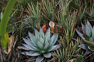
The natural range of the carnivorous plant genus Heliamphora is restricted to the southern Venezuelan states of Amazonas and Bolívar, and to adjacent portions of northern Brazil and western Guyana, an area corresponding to the western part of the Guayana Shield. These plants are largely confined to the summits and foothills of the sandstone table-top mountains of the region, known as tepuis.

Sierra de Aracena mountain range

Sierra de Aracena is the westernmost mountain range of the Sierra Morena, Andalusia, Spain. It is located in the northern part of Huelva Province.

References

  1. Cerros que rodean el Gran Área Metropolitana Archived March 28, 2008, at the Wayback Machine .

Coordinates: 9°51′N84°08′W / 9.850°N 84.133°W / 9.850; -84.133

Geographic coordinate system Coordinate system

A geographic coordinate system is a coordinate system that enables every location on Earth to be specified by a set of numbers, letters or symbols. The coordinates are often chosen such that one of the numbers represents a vertical position and two or three of the numbers represent a horizontal position; alternatively, a geographic position may be expressed in a combined three-dimensional Cartesian vector. A common choice of coordinates is latitude, longitude and elevation. To specify a location on a plane requires a map projection.