The Yellowstone Caldera is a volcanic caldera and supervolcano in Yellowstone National Park in the Western United States, sometimes referred to as the Yellowstone Supervolcano. The caldera and most of the park are located in the northwest corner of Wyoming. The major features of the caldera measure about 34 by 45 miles.

A large igneous province (LIP) is an extremely large accumulation of igneous rocks, including intrusive and extrusive, arising when magma travels through the crust towards the surface. The formation of LIPs is variously attributed to mantle plumes or to processes associated with divergent plate tectonics. The formation of some of the LIPs the past 500 million years coincide in time with mass extinctions and rapid climatic changes, which has led to numerous hypotheses about the causal relationships. LIPs are fundamentally different from any other currently active volcanoes or volcanic systems.

Volcanology of Canada includes lava flows, lava plateaus, lava domes, cinder cones, stratovolcanoes, shield volcanoes, submarine volcanoes, calderas, diatremes, and maars, along with examples of more less common volcanic forms such as tuyas and subglacial mounds. It has a very complex volcanological history spanning from the Precambrian eon at least 3.11 billion years ago when this part of the North American continent began to form.

The Anahim hotspot is a volcanic hotspot located in the West-Central Interior of British Columbia, Canada. One of the few hotspots in North America, the Anahim plume is responsible for the creation of the Anahim Volcanic Belt. This is a 300 km (190 mi) long chain of volcanoes and other magmatic features that have undergone erosion. The chain extends from the community of Bella Bella in the west to near the small city of Quesnel in the east. While most volcanoes are created by geological activity at tectonic plate boundaries, the Anahim hotspot is located hundreds of kilometres away from the nearest plate boundary.
Far Mountain is the highest of over 13 peaks in the Ilgachuz Range in the Anahim Volcanic Belt in British Columbia, Canada. The Ilgachuz Range is one of the three major shield volcanoes that formed the Anahim Volcanic Belt when the North American Plate moved over a hotspot. This is similar to the one which feeds the Hawaiian Islands. The mountain is located in the western part of Itcha Ilgachuz Provincial Park.

The New England hotspot, also referred to as the Great Meteor hotspot, is a long-lived volcanic hotspot in the Atlantic Ocean. The hotspot's most recent eruptive center is the Great Meteor Seamount, and it probably created a short line of mid to late-Cenozoic age seamounts on the African Plate but appears to be currently inactive.
The Abitibi greenstone belt is a 2,800-to-2,600-million-year-old greenstone belt that spans across the Ontario–Quebec border in Canada. It is mostly made of volcanic rocks, but also includes ultramafic rocks, mafic intrusions, granitoid rocks, and early and middle Precambrian sediments.
The High Arctic Large Igneous Province (HALIP) is a Cretaceous large igneous province in the Arctic. The region is divided into several smaller magmatic provinces. Svalbard, Franz Josef Land, Sverdrup Basin, Amerasian Basin, and northern Greenland are some of the larger divisions. Today, HALIP covers an area greater than 1,000,000 km2 (390,000 sq mi), making it one of the largest and most intense magmatic complexes on the planet. However, eroded volcanic sediments in sedimentary strata in Svalbard and Franz Josef Land suggest that an extremely large portion of HALIP volcanics have already been eroded away.
The Lake Timiskaming kimberlite field is Canada's southernmost kimberlite field, located in Northeastern Ontario and western Quebec, Canada. It is within the Lake Timiskaming Structural Zone which contains over 50 kimberlite pipes, several of which are diamondiferous. The Lake Timiskaming kimberlite field formed about 147 million years ago when the North American Plate moved westward over the long-lived New England hotspot, also referred to as the Great Meteor hotspot.

The Muskox intrusion is a layered intrusion in Nunavut, Canada. It is located 144 km (89 mi) northeast of Great Bear Lake and 90 km (56 mi) south of Kugluktuk on Coronation Gulf. It was formed during a large magmatic event during the Proterozoic by hotspot or mantle plume volcanism that emplaced the widespread Coppermine River Group flood basalts.

Volcanology of Northern Canada includes hundreds of volcanic areas and extensive lava formations across Northern Canada. The region's different volcano and lava types originate from different tectonic settings and types of volcanic eruptions, ranging from passive lava eruptions to violent explosive eruptions. Northern Canada has a record of very large volumes of magmatic rock called large igneous provinces. They are represented by deep-level plumbing systems consisting of giant dike swarms, sill provinces and layered intrusions.
The Great Meteor hotspot track, also referred to as the New England hotspot track, is a vast trail of hotspot magmatism in the Northern Hemisphere. It extends over 5,800 km (3,604 mi) from Nunavut in Northern Canada to the northern Atlantic Ocean. Volcanism in the hotspot track was produced by the New England or Great Meteor hotspot, with the oldest magmatic activity dating back at least 214 million years ago during the Late Triassic period. This makes the Great Meteor track one of the oldest hotspot tracks on Earth. It contains over 80 volcanoes, with the most recognizable ones located in the Atlantic Ocean where they form seamounts.

The Franklin dike swarm, also called the Franklin dikes, is a Proterozoic dike swarm of the Franklin Large Igneous Province in Northern Canada. It is one of the several major magmatic events in the Canadian Shield and it was formed 723 million years ago. Areas in the Franklin have been prospected for nickel, copper, and platinum group metals.
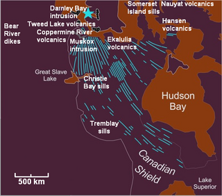
The Mackenzie Large Igneous Province (MLIP) is a major Mesoproterozoic large igneous province of the southwestern, western and northwestern Canadian Shield in Canada. It consists of a group of related igneous rocks that were formed during a massive igneous event starting about 1,270 million years ago. The large igneous province extends from the Arctic in Nunavut to near the Great Lakes in Northwestern Ontario where it meets with the smaller Matachewan dike swarm. Included in the Mackenzie Large Igneous Province are the large Muskox layered intrusion, the Coppermine River flood basalt sequence and the massive northwesterly trending Mackenzie dike swarm.
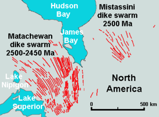
The Mistassini dike swarm is a 2.5 billion year old Paleoproterozoic dike swarm of western Quebec, Canada. It consists of mafic dikes that were intruded in the Superior craton of the Canadian Shield. With an area of 100,000 km2 (39,000 sq mi), the Mistassini dike swarm stands as a large igneous province.
The 2007–2008 Nazko earthquakes were a series of small volcanic earthquakes measuring less than 4.0 on the Richter magnitude scale. They took place in the sparsely populated Nazko area of the Central Interior of British Columbia, Canada starting on October 9, 2007 and ending on June 12, 2008. They occurred just west of Nazko Cone, a small tree-covered cinder cone that last erupted about 7,200 years ago.

The Nipissing sills, also called the Nipissing diabase, is a large 2217– to 2210–million year old group of sills in the Superior craton of the Canadian Shield in Ontario, Canada, which intrude the Huronian Supergroup. Nipissing sills intrude all the Huronian sediments and older basement rocks in the northern margin of the Sudbury Basin; they were emplaced after the faulting and folding of Huronian rocks, and are hornblende gabbro of tholeiitic basalt composition. In the Sudbury–Elliot Lake area the Nipissing diabase is deformed; outcrops are parallel to the fold axes of the Huronian sedimentary rocks. Nipissing diabase intrusions are east-northeast trending and are no wider than 460 m (1,510 ft).

The Pacific Ocean evolved in the Mesozoic from the Panthalassic Ocean, which had formed when Rodinia rifted apart around 750 Ma. The first ocean floor which is part of the current Pacific Plate began 160 Ma to the west of the central Pacific and subsequently developed into the largest oceanic plate on Earth.