Arago hotspot

Last updated

Map of the hotspots on Earth. Arago is #59 Hotspots-more.jpg
Map of the hotspots on Earth. Arago is #59
The Argo hotspot is a component of the South Pacific Ocean Hotspot highway HotspotHighway.jpg
The Argo hotspot is a component of the South Pacific Ocean Hotspot highway

Arago hotspot (also known as the Rurutu hotspot, Young Rurutu hotspot or Atiu hotspot) is a hotspot in the Pacific Ocean, presently located below the Arago seamount close to the island of Rurutu, French Polynesia.

Contents

Arago is part of a family of hotspots in the southern Pacific, which include the Society hotspot and the Macdonald hotspot among others. These are structures beneath Earth's crust which generate volcanoes and which are in part formed by mantle plumes, although Arago itself might have a shallower origin. As the Pacific plate moves over the hotspots, new volcanoes form and old volcanoes are carried away; sometimes an older volcano is carried over the hotspot and is then uplifted as happened with Rurutu.

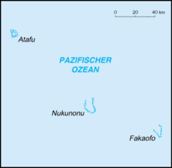
The Arago hotspot is responsible for the formation of Arago seamount and uplift on Rurutu; however reconstructions of the past positions of tectonic plates and geochemistry suggest that other islands and seamounts were constructed by the Arago hotspot during the past 120 million years. These potentially include the Wake Seamounts, the Ratak Chain of the Marshall Islands, numerous seamounts northwest of the Marshall Islands, Tuvalu, Gilbert Islands as well as part of the Austral Islands and Cook Islands.

Name

The hotspot is named after the Arago seamount 130 kilometres (81 mi) southeast of Rurutu. The seamount is named after the French Navy ship Arago, which discovered the seamount in 1993. [2] The ship itself is named after astronomer François Arago. [3] Polynesians knew of the existence of the shallow (27 metres (89 ft) beneath sea level) seamount and named it Tinomana. [2] Before the link to Arago seamount was discovered, the hotspot was also known as "Rurutu hotspot", [4] [5] a name sometimes still used, [6] which is a name also used for an older volcanic chain that starts at Raivavae [7] or President Thiers Bank. [8] Other names are "Young Rurutu" [6] and "Atiu trend"; [5] [9] "Old Rurutu" refers to the Macdonald hotspot. [10]

Geography and geology

The islands in the southern Pacific Ocean French Polynesia relief map.svg
The islands in the southern Pacific Ocean

The southern Pacific Ocean is the site of the South Pacific Superswell, an area where the ocean is anomalously shallow (by about 700 metres (2,300 ft)) [11] [12] and which covers an area of about 3,000 by 3,000 kilometres (1,900 mi × 1,900 mi). [13] Underneath this superswell a large mantle plume might give rise to secondary plumes which in turn form the surface hotspots. [14] Hotspots in the region are the Macdonald hotspot, Marquesas hotspot, Pitcairn hotspot and Society hotspot; [11] of which the first and the last appear to be rooted deep in the mantle. [15] The nature of the volcanism in the area is not completely understood. [16]

Arago Seamount is part of the volcanic chain that forms the Austral Islands and Cook Islands. The 2,200 kilometres (1,400 mi) long chain consists of two separate trends that form two atolls and eleven islands; of these systems one (Macdonald seamount) is a still active volcano. [17] The ages of these islands follow an approximate age progression typical of a hotspot volcano but the occurrence of younger ages on Aitutaki and Rurutu and the chemistry of these younger rocks indicated that there must be more than one hotspot involved. [2] Recent models envisage the presence of a number of separate hotspot tracks in what has been dubbed a "hotspot highway", [1] first named as such in 2010, [18] fed by plumes 1,000–1,200 kilometres (620–750 mi) apart. [19] Further, some hotspots such as the Hawaii hotspot show evidence of movement but the Arago hotspot appears to be static. [20]

The Arago and other hotspots probably are not deep mantle plumes but rather more shallow structures that are also influenced by the lithosphere; [21] in the case of the Arago hotspot the absence of an oceanic plateau that could have been formed by the head of the mantle plume supports such a shallow origin. [22] The upper mantle might be the source of the Arago hotspot. [23] Data on the presence of seismic velocity anomalies and whether they are positive (higher) or negative (lower) beneath Arago are contradictory. [24] Seismic imaging published in 2009 indicates only a slight seismic velocity anomaly shallower than 100 kilometres (62 mi), [25] with no indication of a deep mantle root. [26] More recent research however has endorsed a deep mantle origin for the Arago hotspot. [27] Presently, Arago and the Macdonald hotspot are the two active hotspots of the Austral Islands, [28] but a hotspot that formed Rarotonga may also still be active; additional hotspots in the area are Tubuai, Taukina and Ngatemato. [29] Arago is a long lived hotspot that could be as much as 140 million years old. [30]

Arago Seamount

The eponymous Arago Seamount is a composite volcano with three rift zones, similar to Rurutu. [2] The seamount was formed by three volcanoes with one overlapping the other two; potassium-argon dating on Arago has yielded ages of 230,000 ± 4,000 before present and an imprecise age of 0 years before present. [21] There is some evidence of submarine landslide activity, a typical occurrence on ocean volcanoes, [28] with one landslide scar each on the northern, eastern and western flank. [31] This seamount is considered to be the present location of the hotspot, given its young age; [17] however, unlike Macdonald, Arago Seamount has no recorded historical eruptions. [32]

Hotspots other than the Arago hotspot may have contributed to the growth of the Arago Seamount; a hotspot associated with Raivavae and potentially the President Thiers Bank has been associated through isotope analysis with 8.2 million year old samples taken from Arago Seamount. [33] Other volcanoes in the region also show evidence that they were built by more than one hotspot; this might indicate that their formation is controlled by lithospheric features. [14]

Other islands and seamounts

Hotspot provinces in the Pacific Ocean; Arago belongs to the "Macdonald" province Pacific Basin Island Geography Hotspots.jpg
Hotspot provinces in the Pacific Ocean; Arago belongs to the "Macdonald" province

As the Pacific Plate drifted over the hotspot several volcanoes were formed on the hotspot where weaknesses in the crust allowed the penetration of magma, and were subsequently carried away, [21] [20] at a rate of about 120 millimetres per year (4.7 in/year). [34] Isotope ratios of lead in the volcanic rocks tie the younger volcanics of Rurutu to the Arago hotspot, [21] the ratio in this case is characterized by high radiogenic lead isotope composition ("HIMU"). [35] Some volcanic material from the Arago hotspot may have been recycled in the mantle and mixed into the magmas erupted in the northeastern Lau basin; [36] rocks shed from seamounts created by the Arago hotspot may have been subducted in the Tonga trench which is close to the reconstructed path of the Arago hotspot and then erupted onto the Lau basin. [37] HIMU xenoliths have been found in Tubuai just ahead of Arago Seamount as well. [38]

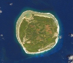
Rurutu already existed before the interaction with the Arago hotspot, having been formed by an older volcanic episode; when it moved over the Arago hotspot a volcanic episode occurred and emplaced lava flows that are formed by basanite and hawaiite. Also, the island and surrounding coral reef were uplifted, [39] and these uplifted coral reefs (known as makatea ) caught the attention of early geologists, who were speculating as to what might have lifted the reefs out of the sea already in 1840. [40] Other uplifted atolls occur northwest from Rurutu and may have formed in the same way when they passed over the Arago hotspot. [41]

The following volcanics are at least tentatively attributed to the Arago hotspot:

The oldest volcanic structures potentially formed by the Arago hotspot are 120 million years old. If their attribution is correct, the Arago hotspot may be the oldest still active hotspot in the Pacific Ocean, ahead of the Hawaii hotspot and the Louisville hotspot. [66] A contrasting viewpoint believes that Arago is a short-lived hotspot with few dated volcanoes along its predicted path. [98] Assuming the first is the case, it is possible to fit Pacific Plate movements over the last 80 million years to the widely separate postulated tracks of this hotspot, the Louisville hotspot and the Hawaii hotspot very well. [105]

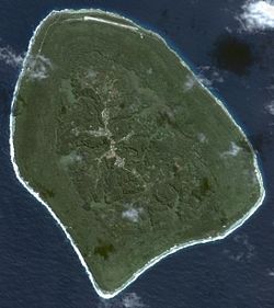
The island of Tubuai is located ahead of the hotspot, and the island will be transported over it in a few million years. As with Rurutu, this interaction will lead to uplift in Tubuai and possibly to renewed volcanism. [39]

Related Research Articles

<span class="mw-page-title-main">Geography of Samoa</span>

The Samoan archipelago is a chain of 16 islands and numerous seamounts covering 3,123 km2 (1,206 sq mi) in the central South Pacific, south of the equator, about halfway between Hawaii and New Zealand, forming part of Polynesia and of the wider region of Oceania. The islands are Savaiʻi, Upolu, Tutuila, ’Uvea, Taʻū, Ofu, Olosega, Apolima, Manono, Nuʻutele, Niulakita, Nuʻulua, Namua, Fanuatapu, Rose Atoll, Nu'ulopa, as well as the submerged Vailuluʻu, Pasco banks, and Alexa Bank.

<span class="mw-page-title-main">Hawaiian–Emperor seamount chain</span> Pacific Ocean geologic feature

The Hawaiian–Emperor seamount chain is a mostly undersea mountain range in the Pacific Ocean that reaches above sea level in Hawaii. It is composed of the Hawaiian ridge, consisting of the islands of the Hawaiian chain northwest to Kure Atoll, and the Emperor Seamounts: together they form a vast underwater mountain region of islands and intervening seamounts, atolls, shallows, banks and reefs along a line trending southeast to northwest beneath the northern Pacific Ocean. The seamount chain, containing over 80 identified undersea volcanoes, stretches about 6,200 km (3,900 mi) from the Aleutian Trench off the coast of the Kamchatka peninsula in the far northwest Pacific to the Kamaʻehuakanaloa Seamount, the youngest volcano in the chain, which lies about 35 kilometres (22 mi) southeast of the Island of Hawaiʻi.

<span class="mw-page-title-main">Pitcairn hotspot</span>

The Pitcairn hotspot is a volcanic hotspot located in the south-central Pacific Ocean. Over the past 11 million years, it has formed the Pitcairn-Gambier hotspot chain. It is responsible for creating the Pitcairn Islands and two large seamounts named Adams and Bounty, as well as atolls at Moruroa, Fangataufa and the Gambier Islands. The hotspot is currently located at Adams and Bounty, which are ~60 kilometers East-Southeast of Pitcairn Island.

<span class="mw-page-title-main">Louisville Ridge</span> Chain of over 70 seamounts in the Southwest Pacific Ocean

The Louisville Ridge, often now referred to as the Louisville Seamount Chain, is an underwater chain of over 70 seamounts located in the Southwest portion of the Pacific Ocean. As one of the longest seamount chains on Earth it stretches some 4,300 km (2,700 mi) from the Pacific-Antarctic Ridge northwest to the Tonga-Kermadec Trench, where it subducts under the Indo-Australian Plate as part of the Pacific Plate. The chains formation is best explained by movement of the Pacific Plate over the Louisville hotspot although others had suggested by leakage of magma from the shallow mantle up through the Eltanin fracture zone, which it follows closely for some of its course.

<span class="mw-page-title-main">Louisville hotspot</span> Volcanic hotspot that formed the Louisville Ridge in the southern Pacific Ocean

The Louisville hotspot is a volcanic hotspot responsible for the volcanic activity that has formed the Louisville Ridge in the southern Pacific Ocean.

<span class="mw-page-title-main">Marquesas hotspot</span> Volcanic hotspot in the Pacific Ocean

The Marquesas hotspot is a volcanic hotspot in the southern Pacific Ocean. It is responsible for the creation of the Marquesas Islands – a group of eight main islands and several smaller ones – and a few seamounts. The islands and seamounts formed between 5.5 and 0.4 million years ago and constitute the northernmost volcanic chain in French Polynesia.

<span class="mw-page-title-main">Samoa hotspot</span> Volcanic hotspot located in the south Pacific Ocean

The Samoa hotspot is a volcanic hotspot located in the south Pacific Ocean. The hotspot model describes a hot upwelling plume of magma through the Earth's crust as an explanation of how volcanic islands are formed. The hotspot idea came from J. Tuzo Wilson in 1963 based on the Hawaiian Islands volcanic chain.

<span class="mw-page-title-main">Macdonald hotspot</span> Volcanic hotspot in the southern Pacific Ocean

The Macdonald hotspot is a volcanic hotspot in the southern Pacific Ocean. The hotspot was responsible for the formation of the Macdonald Seamount, and possibly the Austral-Cook Islands chain. It probably did not generate all of the volcanism in the Austral and Cook Islands as age data imply that several additional hotspots were needed to generate some volcanoes.

<span class="mw-page-title-main">Ocean island basalt</span> Volcanic rock

Ocean island basalt (OIB) is a volcanic rock, usually basaltic in composition, erupted in oceans away from tectonic plate boundaries. Although ocean island basaltic magma is mainly erupted as basalt lava, the basaltic magma is sometimes modified by igneous differentiation to produce a range of other volcanic rock types, for example, rhyolite in Iceland, and phonolite and trachyte at the intraplate volcano Fernando de Noronha. Unlike mid-ocean ridge basalts (MORBs), which erupt at spreading centers (divergent plate boundaries), and volcanic arc lavas, which erupt at subduction zones (convergent plate boundaries), ocean island basalts are the result of intraplate volcanism. However, some ocean island basalt locations coincide with plate boundaries like Iceland, which sits on top of a mid-ocean ridge, and Samoa, which is located near a subduction zone.

Macdonald seamount is a seamount in Polynesia, southeast of the Austral Islands and in the neighbourhood of a system of seamounts that include the Ngatemato seamounts and the Taukina seamounts. It rises 4,200 metres (13,800 ft) from the seafloor to a depth of about 40 metres (130 ft) and has a flat top, but the height of its top appears to vary with volcanic activity. There are some subsidiary cones such as Macdocald seamount. The seamount was discovered in 1967 and has been periodically active with gas release and seismic activity since then. There is hydrothermal activity on Macdonald, and the vents are populated by hyperthermophilic bacteria.

<span class="mw-page-title-main">Wōdejebato</span> Guyot in the Marshall Islands northwest of the smaller Pikinni Atoll

Wōdejebato is a Cretaceous guyot or tablemount in the northern Marshall Islands, Pacific Ocean. Wōdejebato is probably a shield volcano and is connected through a submarine ridge to the smaller Pikinni Atoll 74 kilometres (46 mi) southeast of the guyot; unlike Wōdejebato, Pikinni rises above sea level. The seamount rises for 4,420 metres (14,500 ft) to 1,335 metres (4,380 ft) depth and is formed by basaltic rocks. The name Wōdejebato refers to a sea god of Pikinni.

<span class="mw-page-title-main">Limalok</span> Cretaceous-Paleocene guyot in the Marshall Islands

Limalok is a Cretaceous-Paleocene guyot/tablemount in the southeastern Marshall Islands, one of a number of seamounts in the Pacific Ocean. It was probably formed by a volcanic hotspot in present-day French Polynesia. Limalok lies southeast of Mili Atoll and Knox Atoll, which rise above sea level, and is joined to each of them through a volcanic ridge. It is located at a depth of 1,255 metres (4,117 ft) and has a summit platform with an area of 636 square kilometres (246 sq mi).

<span class="mw-page-title-main">Lo-En</span> Albian–Campanian guyot in the Marshall Islands in the Pacific Ocean

Lo-En or Hess is an Albian–Campanian guyot in the Marshall Islands. One among a number of seamounts in the Pacific Ocean, it was probably formed by a hotspot in what is present-day French Polynesia. Lo-En lies southeast of Eniwetok which rises above sea level, and Lo-En is almost connected to it through a ridge.

<span class="mw-page-title-main">Rarotonga hotspot</span> Volcanic hotspot in the southern Pacific Ocean

The Rarotonga hotspot is a volcanic hotspot in the southern Pacific Ocean. The hotspot is claimed to be responsible for the formation of Rarotonga and some volcanics of Aitutaki but an alternative explanation for these islands most recent volcanics has not been ruled out. Recently alternatives to hotspot activity have been offered for several other intra-plate volcanoes that may have been associated with the Rarotonga hotspot hypothesis.

Vlinder Guyot is a guyot in the Western Pacific Ocean. It rises to a depth of 1,500 metres (4,900 ft) and has a flat top covering an area of 40 by 50 kilometres. On top of this flat top lie some volcanic cones, one of which rises to a depth of 551 metres (1,808 ft) below sea level. Vlinder Guyot has noticeable rift zones, including an older and lower volcano to the northwest and Oma Vlinder seamount south.

<span class="mw-page-title-main">Vailuluʻu</span> Volcanic seamount in the Samoa Islands

Vailuluʻu is a volcanic seamount discovered in 1975. It rises from the sea floor to a depth of 593 m (1,946 ft) and is located between Taʻu and Rose islands at the eastern end of the Samoa hotspot chain. The basaltic seamount is considered to mark the current location of the Samoa hotspot. The summit of Vailuluʻu contains a 2 km wide, 400 m deep oval-shaped caldera. Two principal rift zones extend east and west from the summit, parallel to the trend of the Samoan hotspot. A third less prominent rift extends southeast of the summit.

Malumalu, is a volcanic seamount in American Samoa. Together with Savaii, Upolu and Tutuila, it forms a topographic structure close to the Tonga Trench, which lies about 100 kilometres (62 mi) south. Malumalu lies about 66 kilometres (41 mi) south of Ofu island and is also known as "Southeast Bank". It is about 25 kilometres (16 mi) wide at its base and is part of the Mula ridge, which extends to Tutuila.

<span class="mw-page-title-main">Hotspot highway</span>

The hotspot highway is a term coined in 2010 by Boston University professor Matthew G. Jackson to describe the area of the South Pacific where the postulated tracks of the Samoa, Macdonald, Rurutu, and Rarotonga hotspots all cross paths with one another. While the concept has stood the test of time the key overlapping hot spot tracks appear to be what are now termed the Macdonald hotspot and Arago hotspot which have 10 million years separation but crossed each others paths just south of Samoa. The volcanics of the highway concept are related to the tectonic implications of the breakup of the Ontong Java-Hikurangi-Manihiki large igneous province and of the Pacific large low-shear-velocity province. The tracks are still being redefined by further research and show for example gaps in the Arago hotspot chain with wrong assignment to it rather than the Samoan chain which means we have now little evidence for a cross over between the two.

The Magellan Seamounts stretch from the Mariana Trench to Ita Mai Tai Guyot. Geological studies have demonstrated unique features with implications on understanding of ocean island basalt volcanism. Contracts exist with the International Seabed Authority to exploit the areas potential mineral wealth.

References

  1. 1 2 Finlayson et al. 2018, p. 170.
  2. 1 2 3 4 Bonneville et al. 2002, p. 1024.
  3. "Arago (P 675)". Ministère des Armées (in French). 3 February 2015. Retrieved 26 October 2017.
  4. Bonneville, Dosso & Hildenbrand 2006, p. 252.
  5. 1 2 Konrad et al. 2018, p. 2.
  6. 1 2 3 Finlayson et al. 2018, p. 171.
  7. Neall & Trewick 2008, p. 3299.
  8. Morgan & Morgan 2007, pp. 65–67.
  9. Price et al. 2016, p. 1696.
  10. Konter, Jasper G.; Finlayson, Valerie A.; Engel, Jacqueline; Jackson, Matthew G.; Koppers, Anthony A. P.; Sharma, Shiv K. (22 April 2019). "Shipboard Characterization of Tuvalu, Samoa, and Lau Dredge Samples Using Laser-Induced Breakdown Spectroscopy (LIBS)". Applied Spectroscopy. 73 (6): 625. Bibcode:2019ApSpe..73..623K. doi: 10.1177/0003702819830793 . ISSN   0003-7028. PMID   30700109. S2CID   73411474.
  11. 1 2 Isse et al. 2016, p. 1.
  12. Bonneville, Dosso & Hildenbrand 2006, p. 251.
  13. Suetsugu et al. 2009, p. 2.
  14. 1 2 3 Bonneville, Dosso & Hildenbrand 2006, p. 266.
  15. Isse et al. 2016, p. 2.
  16. Binard et al. 2004, p. 158.
  17. 1 2 Bonneville et al. 2002, p. 1023.
  18. Jackson et al. 2010, p. 1.
  19. Jackson et al. 2020, p. 2.
  20. 1 2 3 4 Jackson et al. 2018, p. 3.
  21. 1 2 3 4 5 Bonneville et al. 2002, p. 1025.
  22. Clouard & Bonneville 2001, p. 695.
  23. Neall & Trewick 2008, p. 3298.
  24. Isse et al. 2016, p. 8-9.
  25. Suetsugu et al. 2009, p. 7.
  26. Suetsugu et al. 2009, p. 9.
  27. Jackson et al. 2018, p. 5.
  28. 1 2 Clouard, V.; Bonneville, A. (2003). Submarine Mass Movements and Their Consequences. Advances in Natural and Technological Hazards Research. Springer, Dordrecht. p. 337. doi:10.1007/978-94-010-0093-2_37. ISBN   9789401039734.
  29. Bonneville, Dosso & Hildenbrand 2006, p. 253.
  30. 1 2 Jackson et al. 2020, p. 9.
  31. Clouard, V.; Bonneville, A. (2004). Oceanic Hotspots. Springer, Berlin, Heidelberg. pp. 227–228. doi:10.1007/978-3-642-18782-7_7. ISBN   9783642622908.
  32. Binard et al. 2004, p. 175.
  33. 1 2 3 Bonneville, Dosso & Hildenbrand 2006, p. 265.
  34. Morgan & Morgan 2007, p. 64.
  35. 1 2 3 4 Jackson et al. 2015, p. 3212.
  36. Price, A. A.; Jackson, M. G.; Blichert-Toft, J.; Arculus, R. J.; Conatser, C. S.; Konter, J. G.; Koppers, A. A. P.; Blusztajn, J. (2014-12-01). "A Geochemical Transect Across the Lau and North Fiji Basins: New Evidence for the Distribution of Multiple Mantle Plume Components". AGU Fall Meeting Abstracts. 23: V23G–07. Bibcode:2014AGUFM.V23G..07P.
  37. 1 2 3 Price et al. 2016, p. 1712.
  38. Koppers et al. 1995, p. 535.
  39. 1 2 Etienne 2014, p. 253.
  40. Etienne 2014, p. 255.
  41. 1 2 Bergersen 1995, p. 607.
  42. "Rurutu". GEOnet Names Server .
  43. 1 2 3 Adam & Bonneville 2008, p. 4.
  44. Adam & Bonneville 2008, p. 6.
  45. "Rimatara". GEOnet Names Server .
  46. Bonneville, Dosso & Hildenbrand 2006, p. 256.
  47. Adam & Bonneville 2008, p. 8.
  48. "Mangaia". GEOnet Names Server .
  49. "Îles Maria". GEOnet Names Server .
  50. 1 2 3 4 5 Morgan & Morgan 2007, p. 63.
  51. 1 2 3 Morgan & Morgan 2007, p. 68.
  52. "Mitiaro". GEOnet Names Server .
  53. "Takutea". GEOnet Names Server .
  54. "Manuae". GEOnet Names Server .
  55. "Atiu". GEOnet Names Server .
  56. "Mauke". GEOnet Names Server .
  57. Jackson et al. 2015, p. 3213.
  58. Bonneville, Dosso & Hildenbrand 2006, p. 265,266.
  59. "Aitutaki". GEOnet Names Server .
  60. Jackson et al. 2020, p. 6.
  61. "Palmerston Atoll". GEOnet Names Server .
  62. Google (4 December 2021). "Rose Atoll" (Map). Google Maps . Google. Retrieved 4 December 2021.
  63. Buff et al. 2021, p. 542.
  64. Buff et al. 2021, p. 543.
  65. Price et al. 2022, p. 2.
  66. 1 2 Koppers, A. A.; Konter, J. G.; Jackson, M. G. (2013-12-01). "Insights Into the Origin of the Longest-lived Hotspot in the Pacific: Clues from the Tuvalus". AGU Fall Meeting Abstracts. 13: V13F–2668. Bibcode:2013AGUFM.V13F2668K.
  67. Jackson et al. 2010, p. 17.
  68. 1 2 3 Price et al. 2022, p. 16.
  69. Finlayson, V.; Konter, J. G.; Konrad, K.; Price, A. A.; Koppers, A. A. P.; Jackson, M. G. (2016-12-01). "Identification of a Hawaiian-Emperor Style Bend in the Tuvalu Segment of the Rurutu Hotspot". AGU Fall Meeting Abstracts. 52: DI52A–05. Bibcode:2016AGUFMDI52A..05F.
  70. Jackson et al. 2018, p. 2.
  71. Konter, Jasper G.; Finlayson, Valerie A.; Engel, Jacqueline; Jackson, Matthew G.; Koppers, Anthony A. P.; Sharma, Shiv K. (22 April 2019). "Shipboard Characterization of Tuvalu, Samoa, and Lau Dredge Samples Using Laser-Induced Breakdown Spectroscopy (LIBS)". Applied Spectroscopy. 73 (6): 625. Bibcode:2019ApSpe..73..623K. doi: 10.1177/0003702819830793 . ISSN   0003-7028. PMID   30700109.
  72. Jackson et al. 2020, p. 10.
  73. "Tuvalu". GEOnet Names Server .
  74. 1 2 Finlayson et al. 2018, p. 175.
  75. Finlayson et al. 2018, p. 177.
  76. Finlayson, V.; Konter, J. G.; Konrad, K.; Koppers, A. A. P.; Jackson, M. G. (2014-12-01). "The Rurutu Hotspot: Isotopic and Trace Element Evidence of HIMU Hotspot Volcanism in the Tuvalu Islands". AGU Fall Meeting Abstracts. 33: V33C–4883. Bibcode:2014AGUFM.V33C4883F.
  77. Konrad et al. 2018, p. 3.
  78. "Gilbert Ridge". GEOnet Names Server .
  79. 1 2 Konter et al. 2008, p. 290.
  80. "Tokelau". GEOnet Names Server .
  81. Konter et al. 2008, p. 293.
  82. 1 2 3 Koppers et al. 1995, p. 538.
  83. Haggerty & Silva 1995, p. 940.
  84. 1 2 3 4 5 Bergersen 1995, p. 606.
  85. 1 2 Haggerty & Silva 1995, p. 939.
  86. Koppers et al. 1995, p. 541.
  87. Bergersen 1995, p. 606,610.
  88. Google (14 April 2019). "Wake Island" (Map). Google Maps . Google. Retrieved 14 April 2019.
  89. Wei et al. 2022, p. 14.
  90. Wei et al. 2022, p. 17.
  91. Wei et al. 2022, p. 2.
  92. 1 2 Ozima, Honda & Saito 1977, p. 476.
  93. Ozima, Honda & Saito 1977, p. 482.
  94. Koppers et al. 1995, p. 543.
  95. Wei et al. 2022, p. 10.
  96. Yan, Quanshu; Milan, Luke; Saunders, J. Edward; Shi, Xuefa (2021). "Petrogenesis of Basaltic Lavas From the West Pacific Seamount Province: Geochemical and Sr-Nd-Pb-Hf Isotopic Constraints". Journal of Geophysical Research: Solid Earth. 126 (5): 12. Bibcode:2021JGRB..12621598Y. doi:10.1029/2020JB021598. ISSN   2169-9356. S2CID   236615480.
  97. Wei et al. 2022, p. 12.
  98. 1 2 Clouard & Bonneville 2001, p. 697.
  99. Pringle 1992, p. 393.
  100. Pringle 1992, p. 389.
  101. Pringle 1992, p. 390.
  102. 1 2 Pringle 1992, p. 394.
  103. 1 2 Staudigel, Hubert; Park, K.-H.; Pringle, M.; Rubenstone, J.L.; Smith, W.H.F.; Zindler, A. (1991). "The longevity of the South Pacific isotopic and thermal anomaly". Earth and Planetary Science Letters. 102 (1): 31. Bibcode:1991E&PSL.102...24S. doi: 10.1016/0012-821x(91)90015-a .
  104. Franco, Heather; Abbott, Dallas (1999-01-01). "Gravity signatures of terrane accretion". Lithos. 46 (1): 6. Bibcode:1999Litho..46....5F. doi:10.1016/S0024-4937(98)00060-7.
  105. Gaastra, Kevin M.; Gordon, Richard G.; Woodworth, Daniel T. (July 2022). "Quantification of Pacific Plate Hotspot Tracks Since 80 Ma". Tectonics. 41 (7). Bibcode:2022Tecto..4106772G. doi: 10.1029/2021TC006772 .

Sources

23°26′S150°44′W / 23.44°S 150.73°W / -23.44; -150.73 [1]

  1. Clouard & Bonneville 2001, p. 697.