
In geology, hotspots are volcanic locales thought to be fed by underlying mantle that is anomalously hot compared with the surrounding mantle. Examples include the Hawaii, Iceland, and Yellowstone hotspots. A hotspot's position on the Earth's surface is independent of tectonic plate boundaries, and so hotspots may create a chain of volcanoes as the plates move above them.

The Iceland hotspot is a hotspot which is partly responsible for the high volcanic activity which has formed the Iceland Plateau and the island of Iceland. It contributes to understanding the geological deformation of Iceland.
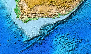
The Agulhas Bank is a broad, shallow part of the southern African continental shelf which extends up to 250 km (160 mi) south of Cape Agulhas before falling steeply to the abyssal plain.

An oceanic or submarine plateau is a large, relatively flat elevation that is higher than the surrounding relief with one or more relatively steep sides.

The New England hotspot, also referred to as the Great Meteor hotspot and sometimes the Monteregian hotspot, is a volcanic hotspot in the North Atlantic Ocean. It created the Monteregian Hills intrusions in Montreal and Montérégie, the White Mountains intrusions in New Hampshire, the New England and Corner Rise seamounts off the coast of North America, and the Seewarte Seamounts east of the Mid-Atlantic Ridge on the African Plate, the latter of which include its most recent eruptive center, the Great Meteor Seamount. The New England, Great Meteor, or Monteregian hotspot track has been used to estimate the movement of the North American Plate away from the African Plate from the early Cretaceous period to the present using the fixed hotspot reference frame.

The Great Meteor Seamount, also called the Great Meteor Tablemount, is a guyot and the largest seamount in the North Atlantic with a volume of 24,000 km3 (5,800 cu mi). It is one of the Seewarte Seamounts, rooted on a large terrace located south of the Azores Plateau. The crust underlying Great Meteor has an age of 85 million years, deduced from the magnetic anomaly 34 (An34) at this location.
The Boomerang Seamount is an active submarine volcano, located 18 km (11 mi) northeast of Amsterdam Island, France. It was formed by the Amsterdam-Saint Paul hotspot and has a 2 km (1.2 mi) wide caldera that is 200 m (660 ft) deep. Hydrothermal activity occurs within the caldera. The sampled rocks are basalt and picrite basalt.

The South American–Antarctic Ridge or simply American-Antarctic Ridge is the tectonic spreading center between the South American plate and the Antarctic plate. It runs along the sea-floor from the Bouvet triple junction in the South Atlantic Ocean south-westward to a major transform fault boundary east of the South Sandwich Islands. Near the Bouvet triple junction the spreading half rate is 9 mm/a (0.35 in/year), which is slow, and the SAAR has the rough topography characteristic of slow-spreading ridges.

The Tristan hotspot is a volcanic hotspot which is responsible for the volcanic activity which forms the volcanoes in the southern Atlantic Ocean. It is thought to have formed the island of Tristan da Cunha and the Walvis Ridge on the African Plate.
The Walvis Ridge is an aseismic ocean ridge in the southern Atlantic Ocean. More than 3,000 km (1,900 mi) in length, it extends from the Mid-Atlantic Ridge, near Tristan da Cunha and the Gough Islands, to the African coast. The Walvis Ridge is one of few examples of a hotspot seamount chain that links a flood basalt province to an active hotspot. It is also considered one of the most important hotspot tracks because the Tristan Hotspot is one of few primary or deep mantle hotspots.

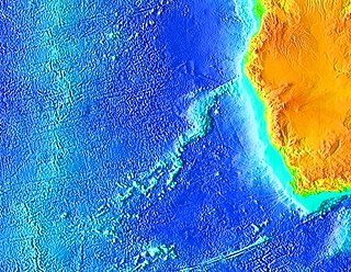
The Agulhas Plateau is an oceanic plateau located in the south-western Indian Ocean about 500 km (310 mi) south of South Africa. It is a remainder of a large igneous province (LIP), the Southeast African LIP, that formed 140 to 95 million years ago (Ma) at or near the triple junction where Gondwana broke-up into Antarctica, South America, and Africa. The plateau formed 100 to 94 Ma together with Northeast Georgia Rise and Maud Rise when the region passed over the Bouvet hotspot.

The Agulhas Basin is an oceanic basin located south of South Africa where the South Atlantic Ocean and south-western Indian Ocean meet. Part of the African plate, it is bounded by the Agulhas Ridge to the north and the Southwest Indian Ridge to the south; by the Meteor Rise to the west and the Agulhas Plateau to the east. Numerous bathymetric anomalies hint at the basin's dynamic tectonic history.
The Agulhas Passage is an abyssal channel located south of South Africa between the Agulhas Bank and Agulhas Plateau. About 50 km (31 mi) wide, it connects the Natal Valley and Transkei Basin in the north to the Agulhas Basin in the south and is the only near-shore connection between the south-western Indian Ocean and South Atlantic Ocean.

The Northeast Georgia Rise is an oceanic plateau located in the South Atlantic Ocean northeast of South Georgia Island and west of the Falkland Plateau.
Foundation Seamounts are a series of seamounts in the southern Pacific Ocean. Discovered in 1992, these seamounts form a 1,350 kilometres (840 mi) long chain which starts from the Pacific-Antarctic Ridge. Some of these seamounts may have once emerged from the ocean.
The Discovery Seamounts are a chain of seamounts in the Southern Atlantic Ocean, including Discovery Seamount. The seamounts are 850 kilometres (530 mi) east of Gough Island and once formed islands. Various volcanic rocks as well as glacial dropstones and sediments have been dredged from the Discovery Seamounts.
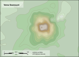
Vema Seamount is a seamount in the South Atlantic Ocean. Discovered in 1959 by a ship with the same name, it lies 1,600 kilometres (1,000 mi) from Tristan da Cunha and 1,000 kilometres (620 mi) northwest of Cape Town. The seamount has a flat top at a mean depth of 73 metres which was eroded into the seamount at a time when sea levels were lower; the shallowest point lies at 26 metres depth. The seamount was formed between 15-11 million years ago, possibly by a hotspot.
Crough Seamount is a seamount in the Pacific Ocean, within the exclusive economic zone of Pitcairn. It rises to a depth of 650 metres (2,130 ft) and is paired with a taller but overall smaller seamount to the east. This seamount has a flat top and probably formed an island in the past. It is about 7-8 million years old, although a large earthquake recorded at its position in 1955 may indicate a recent eruption.
Sierra Leone hotspot is a proposed hotspot in the Atlantic Ocean.
