Hayward Area Recreation and Park District

Last updated
Hayward Plunge at Memorial Park Haywardplunge.jpg
Hayward Plunge at Memorial Park

The Hayward Area Recreation and Park District (H.A.R.D.) is the park management agency for most of the parks in the city of Hayward, California. It was created in 1944 [1] and is an independent special district under California law. [2] H.A.R.D. is the largest recreation district in California. [3] It also manages parks in the bordering unincorporated communities of Castro Valley, San Lorenzo, Fairview, Ashland and Cherryland. It manages the park grounds for numerous schools in the region. Events and classes are scheduled and listed in a quarterly brochure. [4] The parks' 2021 budget is $24,306,495. [5]

Contents

gate at Rowell Rodeo Park Rowellranchsilhouette.jpg
gate at Rowell Rodeo Park

List of parks

This is a list of parks managed by H.A.R.D., by city or unincorporated community, with indications of significant park features [6] beyond picnic and open areas, parking, ball courts, restrooms, etc.

Hayward

73 parks are operated in Hayward: [7]

  • Alden E. Oliver Sports Park of Hayward
  • Bechtel Mini Park
  • Bidwell Park
  • Birchfield Park
  • Brenkwitz High School
  • Matt Jimenez Community Center
    • youth center, gymnasium
  • Bret Harte School
  • Burbank School
    • recreation center
  • Cannery Park
  • Canyon View Park
  • Centennial Park
  • Cherryland Park
  • Children's Park at Alex Giualini Plaza
  • Christian Penke Park
  • College Heights Park
  • Colonial Acres School
  • Douglas Morrisson Theatre
    • theatrical venue [8]
  • East Avenue Park
    • amphitheatre
  • East Avenue School
  • Eden Greenway
  • El Rancho Verde School
  • Eldridge Park
  • Fairmont Linear Park
  • Fairview Park
    • recreation center
  • Fairway Greens Park
  • Gansberger Park
  • Gordon E. Oliver Eden Shores Park
  • Greenbelt Trails (see Memorial Park)
    • hiking/riding trails
  • Greenwood Park
  • Harder School
  • Haymont Mini Park
  • Hayward Area Senior Center
    • community center
  • Hayward High School
    • swim center
  • Hayward Shoreline Interpretive Center [9]
  • Jalquin Vista Park
  • Japanese Gardens
    • wedding site
  • Kennedy Park
    • group picnic area, petting zoo, children's train, merry-go-round [10]
  • La Placita Mini Park
  • Lakeridge Park
  • Longwood Park
  • Martin Luther King Field
  • Memorial Park
    • group picnic area, hiking/riding trails (access point for Greenbelt Trails), swim center/indoor pool (Hayward Plunge) [11]
  • Mt. Eden High School
  • Mt. Eden Park
    • group picnic area, softball field, Mt. Eden Mansion [12]
  • Nuestro Parquecito
  • Old Highlands Park
    • hiking/riding trails
  • Palma Ceia Park
    • recreation center building
  • Park School
  • Pexioto School
  • PhotoCentral
  • Rancho Arroyo Park
  • Ruus Park
  • Schafer Park
  • Shepherd School
  • Silver Star Veterans Park
    • hiking/riding trails
    • group picnic area, hiking/riding trails, pro shop, restaurant, driving range
  • Sorensdale Park
    • disabled citizen center
  • Southgate Park
    • group picnic area, hiking/riding trails, community center building
  • Spring Grove Park
  • Stonybrook Park
  • Stratford Village Park
    • skate area
  • Sunset Adult School
    • swim center
  • Tennyson High School
  • Tennyson Park
    • group picnic area, skate area
  • Twin Bridges Park
  • Tyrrell School
  • Valle Vista Park
  • Weekes Park
    • group picnic area, community center building, art studio
  • Weekes Community Center

Ashland

Three parks are operated in Ashland: [14] [15]

Castro Valley

Twenty parks are operated in Castro Valley: [16]

  • Adobe Center
  • Bay Trees Park
  • Canyon Middle School
  • Carlos Bee Park
  • Castro Valley High School
  • Castro Valley Park and Community Center
    • community center, Chanticleer's Little Theatre [18]
  • Deerview Park
  • Earl Warren Park
  • Greenridge Park
  • Independent School
  • Kenneth C. Aitken Senior and Community Center
    • community center, senior center
  • Laurel Park
  • Marshall School
  • Palomares Hills Park
  • Parsons Park
  • Proctor School
  • Redwood School
  • Rowell Ranch
    • rodeo park. The park is a current, and historic site, for rodeos, and was frequented by Western film stars in the past. [19] [20] [21]
  • Strobridge School
  • Vannoy School

Cherryland

Four parks are operated in Cherryland: [22]

  • Cherryland Park
    • Playground and picnic grounds
  • Old Creek Dog Park of Cherryland
  • Meek Estate Park
    • Historic Building, cherry orchard
  • Cherryland Community Center

Fairview

Four parks are operated in Fairview: [22]

  • San Felipe Park
    • community building
  • Sulphur Creek Nature Center
    • nature center, including animal rehabilitation facilities [23]
  • Lakeridge Park
  • East Avenue Park

San Lorenzo

Ten parks are operated in San Lorenzo: [24]

Other sites

H.A.R.D. has partnered with the Hayward Area Historical Society to restore the Meek Mansion, and to manage the open space portions of the site. [26] The Hayward Area Shoreline Planning Agency, created in 1970, is a joint project of H.A.R.D., the East Bay Regional Parks District and the city of Hayward to protect shoreline resources from San Lorenzo Creek to New Alameda Creek on the border of Hayward and Fremont. [27]

Hayward parks not managed by HARD

Julio Bras Portuguese Centennial Park and Newman Park in downtown Hayward are not managed by HARD.

Column at Julio Bras Park, not managed by HARD Portuguese Park Hayward column.jpg
Column at Julio Bras Park, not managed by HARD

Related Research Articles

Jackson County, Michigan County in Michigan, United States

Jackson County is a county located in the U.S. state of Michigan. Its population was 160,366 as of the 2020 Census. The county seat is Jackson. The county was set off in 1829 and organized in 1832. It is named for U.S. President Andrew Jackson and considered to be one of Michigan's "Cabinet counties", named for members of Jackson's Cabinet.

<span class="mw-page-title-main">Alameda County, California</span> County in California, United States

Alameda County is a county located in the U.S. state of California. As of the 2020 census, the population was 1,682,353, making it the 7th-most populous county in the state and 21st most populous nationally. The county seat is Oakland. Alameda County is in the San Francisco Bay Area, occupying much of the East Bay region.

Ashland, California Unincorporated community in California, United States

Ashland is a census-designated place (CDP) and unincorporated community in Alameda County, California, United States. The population was 23,823 at the 2020 census. Ashland is located between the city of San Leandro to the north, the unincorporated community of Cherryland to the south, the unincorporated community of Castro Valley to the east, and the unincorporated community of San Lorenzo to the southwest.

Castro Valley, California CDP in California, United States

Castro Valley is a census-designated place (CDP) in Alameda County, California, United States. As of the 2010 census, it is the fifth most populous unincorporated area in California and the twenty-third most populous in the United States. The population was 66,441 at the 2020 census.

Cherryland, California Unincorporated Community in California, United States

Cherryland is an unincorporated community and census-designated place (CDP) in Alameda County, California, United States. Cherryland is located between Ashland to the north and the city of Hayward to the south. The population was 15,808 at the 2020 census.

<span class="mw-page-title-main">Hayward, California</span> City in the state of California, United States

Hayward is a city located in Alameda County, California in the East Bay subregion of the San Francisco Bay Area. With a population of 162,954 as of 2020, Hayward is the sixth largest city in the Bay Area and the third largest in Alameda County. Hayward was ranked as the 34th most populous municipality in California. It is included in the San Francisco–Oakland–San Jose Metropolitan Statistical Area by the US Census. It is located primarily between Castro Valley, San Leandro and Union City, and lies at the eastern terminus of the San Mateo–Hayward Bridge. The city was devastated early in its history by the 1868 Hayward earthquake. From the early 20th century until the beginning of the 1980s, Hayward's economy was dominated by its now defunct food canning and salt production industries.

East Bay Regional Park District

The East Bay Regional Park District (EBRPD) is a special district operating in Alameda County and Contra Costa County, California, within the East Bay area of the San Francisco Bay Area. It maintains and operates a system of regional parks which is the largest urban regional park district in the United States. The administrative office is located in Oakland.

Connetquot River State Park Preserve State park in Suffolk County, New York

Connetquot River State Park Preserve is a 3,473-acre (14.05 km2) state park and conservation area in the Town of Islip in Suffolk County, New York in the United States. The park contains the Long Island Environmental Interpretive Center as well as the Southside Sportsmens Club District, which was listed on the National Register of Historic Places in 1973.

Henry Cowell Redwoods State Park State park in Santa Cruz County, California, United States

Henry Cowell Redwoods State Park is a state park of California, United States, preserving mainly forest and riparian areas in the watershed of the San Lorenzo River, including a grove of old-growth coast redwood. It is located in Santa Cruz County, primarily in the area between the cities of Santa Cruz and Scotts Valley, near the community of Felton and the University of California at Santa Cruz. The park includes a non-contiguous extension in the Fall Creek area north of Felton. The 4,623-acre (1,871 ha) park was established in 1954.

Eden Township, Alameda County, California

Eden Township is a former township of Alameda County, California in the San Francisco Bay Area region, which includes the present-day cities of Hayward and San Leandro, as well as the unincorporated census-designated areas of Ashland, Castro Valley, Cherryland, Fairview, and San Lorenzo. It was created from a group of Mexican land grants that were added to Alameda County when the county was established in 1853. Today there are several public and private agencies serving the region.

Anthony Chabot Regional Park

Anthony Chabot Regional Park is a regional park in Oakland, Alameda County, California in the United States. It is part of the East Bay Regional Park District system, and covers 5,067 acres (2,051 ha) in the San Leandro Hills adjacent to Oakland, San Leandro and Castro Valley. Popular activities include hiking, cycling and horseback riding. A gun range operated by the Chabot Gun Club was shut down in 2016, following complaints about pollution.

Fairview, Michigan Unincorporated community in Michigan, United States

Fairview is an unincorporated community in Oscoda County in the U.S. state of Michigan. It is located within Comins Township at the intersection of highways M-33 and M-72 at 44°43′30″N84°03′04″W.

Outdoor recreation Recreation engaged in out of doors

Outdoor recreation or outdoor activity refers to recreation done outside, most commonly in natural settings. The activities that encompass outdoor recreation vary depending on the physical environment they are being carried out in. These activities can include fishing, hunting, backpacking, and horseback riding — and can be completed individually or collectively. Outdoor recreation is a broad concept that encompasses a varying range of activities and landscapes.
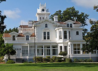
Hayward Unified School District Public school district in Hayward, California

The Hayward Unified School District (HUSD) is a public school district serving the city of Hayward, California, in Alameda County, in the United States. Supervised by the superintendent and the HUSD board of trustees, the district serves about 21,000 students in 30 schools, and employs more than 950 teachers. The current superintendent is Dr. Matt Wayne and the current board of trustees president is Dr. April Oquenda.

<span class="mw-page-title-main">San Lorenzo Creek</span> Creek in Hayward, California

San Lorenzo Creek is a 10.7-mile-long (17.2 km) year-round natural stream flowing through Hayward, California and other neighboring unincorporated communities into San Francisco Bay at the Hayward Regional Shoreline.

Hayward Area Historical Society

Hayward Area Historical Society(HAHS) is a nonprofit organization dedicated to documenting the history of the city of Hayward, California and adjacent communities. These areas include San Lorenzo, Ashland, Cherryland, Castro Valley, Fairview, the former communities of Russell City, Mount Eden, Schafer Park, and other parts of unincorporated Alameda County. The society was founded in 1956. Their museum in Downtown Hayward closed in 2012. Their new facility opened nearby in 2014.

Rancho Conejo Playfields Park in Newbury Park, California

Rancho Conejo Playfields is a 13 acres (5.3 ha) multi-use community park in Newbury Park, California, adjacent to Conejo Canyons Open Space and the Arroyo Conejo Nature Preserve which includes 302 acres (122 ha) of public open-space land and numerous trails in the western Simi Hills.

Walnut Grove Park Community park in Newbury Park, California

Walnut Grove Park is a 6.5 acre community park in Newbury Park, California, United States, situated immediately south of the U.S. 101 Ventura Freeway on Newbury Road. Named for its many walnut trees, the park land was acquired in 1981 and ultimately developed into a community park in 1994. It contains a playground, an outdoor handball court, three BBQ grills, basketball courts, numerous picnic tables, trails, and open-space. It is operated by the Conejo Recreation & Park District (CRPD), and it is adjacent to the Walnut Grove Equestrian Center and its 14 acres of trails, horse arenas, stalls, picnic tables, and various trails for hikers and equestrians. The park is relatively close to the Arroyo Conejo Open Space and its many trails leading for instance to Wildwood Regional Park, which is accessible from its closest trailhead between 507 Kalinda Pl. and 504 Paseo Grande on West Hillcrest Drive. Walnut Grove Park is located along a smaller offspring from the Arroyo Conejo, and is one of only three off-leash dog parks in the Conejo Valley.

Dos Vientos Community Park

Dos Vientos Community Park in southwestern Newbury Park, CA is the largest of Conejo Recreation & Park District’s public parks in the Conejo Valley. It is adjacent to the Dos Vientos Community Center, which offers a preschool, sports, and other activities. The park contains sand volleyball courts, baseball-, basketball- and tennis courts, soccer fields, playground areas, and picnic tables and barbecue grills. It is adjacent to the Dos Vientos Open Space through the Park View Trail, which is a 1,216 acre natural open-space, bordering an additional 16,000 acres of open space stretching over the Santa Monica Mountains National Recreation Area to the Pacific Ocean. The Park View Trail ends at Via Ricardo, directly across the road from the Powerline Trail and Dos Vientos Open Space.

References

  1. "Hayward Recreation, Hayward Parks, Hayward Park District, Hayward Sports, Hayward Open Space". Villageprofile.com. Archived from the original on 2013-03-03. Retrieved 2013-02-28.
  2. "Hayward Area Recreation and Park District". Haywardrec.org. Archived from the original on 2013-04-20. Retrieved 2013-02-28.
  3. "Hayward Area Recreation and Park District". Haywardrec.org. Retrieved 2013-02-28.
  4. "Hayward Area Recreation and Park District". Haywardrec.org. Archived from the original on 2013-04-20. Retrieved 2013-02-28.
  5. "Archived copy". Archived from the original on 2021-10-01. Retrieved 2021-10-01.{{cite web}}: CS1 maint: archived copy as title (link)
  6. "Layout 1" (PDF). Archived from the original (PDF) on 2008-07-03. Retrieved 2013-02-28.
  7. "Hayward Area Recreation and Park District". Haywardrec.org. Archived from the original on 2013-04-13. Retrieved 2013-02-28.
  8. Douglas Morrisson Theatre, Hayward, CA. "The Douglas Morrisson Theatre online". dmtonline.org. Retrieved 2013-02-28.{{cite web}}: CS1 maint: multiple names: authors list (link)
  9. "Hayward Area Recreation and Park District". Haywardrec.org. Retrieved 2013-02-28.
  10. "Hayward Area Recreation and Park District". Haywardrec.org. Archived from the original on 2013-01-29. Retrieved 2013-02-28.
  11. "Archived copy" (PDF). Archived from the original (PDF) on 2012-03-16. Retrieved 2011-05-24.{{cite web}}: CS1 maint: archived copy as title (link)
  12. "Hayward Area Recreation and Park District". Haywardrec.org. 2006-05-01. Archived from the original on 2013-04-13. Retrieved 2013-02-28.
  13. "Welcome to PhotoCentral Online". Photocentral.org. Retrieved 2013-02-28.
  14. "Hayward Area Recreation and Park District". Haywardrec.org. Archived from the original on 2013-04-13. Retrieved 2013-02-28.
  15. Community locator. Alameda County http://communitylocator.acgov.org/ . Retrieved 12 February 2021.{{cite web}}: Missing or empty |title= (help)
  16. "Hayward Area Recreation and Park District". Haywardrec.org. Archived from the original on 2013-04-13. Retrieved 2013-02-28.
  17. "Castro Valley High School". Castrovalleyhigh.org. Archived from the original on 2011-08-13. Retrieved 2013-02-28.
  18. "Archived copy" (PDF). Archived from the original (PDF) on 2012-03-16. Retrieved 2011-05-24.{{cite web}}: CS1 maint: archived copy as title (link)
  19. "Hayward Area Recreation and Park District". Haywardrec.org. Archived from the original on 2013-04-20. Retrieved 2013-02-28.
  20. "Archived copy" (PDF). Archived from the original (PDF) on 2012-03-16. Retrieved 2011-05-24.{{cite web}}: CS1 maint: archived copy as title (link)
  21. "The Harry Rowell Family". The Harry Rowell Family. Retrieved 2013-02-28.
  22. 1 2 Community Locator. Alameda County http://communitylocator.acgov.org/ . Retrieved 12 February 2021.{{cite web}}: Missing or empty |title= (help)
  23. "Hayward Area Recreation and Park District". Haywardrec.org. Retrieved 2013-02-28.
  24. "Hayward Area Recreation and Park District". Haywardrec.org. Archived from the original on 2013-04-13. Retrieved 2013-02-28.
  25. "Archived copy" (PDF). Archived from the original (PDF) on 2012-03-16. Retrieved 2011-05-24.{{cite web}}: CS1 maint: archived copy as title (link)
  26. "Powered by Google Docs" . Retrieved 2013-02-28.
  27. "Hayward Regional Shoreline". Sanlorenzoexpress.com. Retrieved 2013-02-28.

Coordinates: 37°40′16″N122°04′36″W / 37.671065°N 122.076611°W / 37.671065; -122.076611