
Livermore is a city in Alameda County, California. With a 2020 population of 87,955, Livermore is the most populous city in the Tri-Valley, giving its name to the Livermore Valley. It is located on the eastern edge of California's San Francisco Bay Area, making it the easternmost city in the area. The current mayor is John Marchand.

Pleasanton is a city in Alameda County, California, United States. Located in the Amador Valley, it is a suburb in the East Bay region of the San Francisco Bay Area. The population was 79,871 at the 2020 census. In 2005 and 2007, Pleasanton was ranked the wealthiest middle-sized city in the United States by the Census Bureau. Pleasanton is home to the headquarters of Safeway, Workday, Ellie Mae, Roche Molecular Diagnostics, Blackhawk Network Holdings, Veeva Systems, and Simpson Manufacturing Company. Other major employers include Kaiser Permanente, Oracle and Macy's. Although Oakland is the Alameda County seat, a few county offices are located in Pleasanton. The Alameda County Fairgrounds are located in Pleasanton, where the county fair is held during the last week of June and the first week of July. Pleasanton Ridge Regional Park is located on the west side of town.
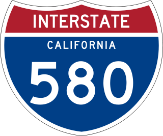
Interstate 580 (I-580) is an approximately 76-mile-long (122 km) east–west auxiliary Interstate Highway in Northern California. The heavily traveled spur route of I-80 runs from US Route 101 (US 101) in San Rafael in the San Francisco Bay Area to I-5 at a point outside the southern city limits of Tracy in the Central Valley. I-580 forms a concurrency with I-80 between Albany and Oakland, the latter of which is the location of the MacArthur Maze interchange immediately east of the San Francisco–Oakland Bay Bridge. I-580 provides a connection from the Bay Area to the southern San Joaquin Valley and Southern California via I-5, as I-5 bypasses the Bay Area to the east.

The Tri-Valley area is grouping of three valleys in the East Bay region of California's Bay Area. The three valleys are Amador Valley, San Ramon Valley, and Livermore Valley. The Tri-Valley encompasses the cities of Dublin, Livermore, Pleasanton and San Ramon, the town of Danville and the CDPs of Alamo, Blackhawk and Diablo. The area is known for its Mediterranean climate, wineries, and nature. It is primarily suburban in character. The United States Census Bureau defines an urban area centered in the cities of Livermore, Pleasanton, and Dublin with a 2020 population of 240,381, ranked 167th in the United States in terms of population. The total population of the area is estimated to be 361,000. It offers more affordable living accommodations than the cities of San Francisco and San Jose.

The Altamont Corridor Express is a commuter rail service in California, connecting Stockton and San Jose during peak hours only. ACE is named for the Altamont Pass, through which it runs. Service is managed by the San Joaquin Regional Rail Commission, and operations are contracted to Herzog Transit Services. The 86-mile (138 km) route includes ten stops, with travel time about 2 hours and 12 minutes end-to-end. In 2023, the line had a ridership of 576,300, or about 2,500 per weekday as of the fourth quarter of 2023. ACE uses Bombardier BiLevel Coaches, MPI F40PH-3C locomotives, and Siemens Charger locomotives.

Wheels is a public bus service in the Tri-Valley region (southeast Alameda County) of the San Francisco Bay Area in California, United States. It is operated by the Livermore Amador Valley Transit Authority (LAVTA). Wheels operates local and limited-stop service in Dublin, Pleasanton, and Livermore, with limited service into Contra Costa County along Interstate 680. The LAVTA was formed in 1985; service began in Dublin and Pleasanton in 1986. In 1987, it took over the 1978-opened Rideo service in Livermore. In 2023, the system had a ridership of 1,289,600, or about 5,100 per weekday as of the fourth quarter of 2023.

Altamont Pass, formerly Livermore Pass, is a low mountain pass in the Diablo Range of Northern California between Livermore in the Livermore Valley and Tracy in the San Joaquin Valley. The name is actually applied to two distinct but nearby crossings of the range. The lower of the two, at an elevation of 741 ft (226 m), carries two railroad rights-of-way (ROWs) and Altamont Pass Road, part of the old Lincoln Highway and the original alignment of US 50 before it was bypassed in 1937. The bypass route travels over the higher summit, at 1,009 ft (308 m), and now carries Interstate 580, a major regional highway heavily congested by Central Valley suburbanization.

The Iron Horse Regional Trail is a rail trail for pedestrians, horse riders and bicycles in the East Bay Area in California.

Interstate 205 (I-205) is an east–west auxiliary Interstate Highway in the San Joaquin Valley in Northern California. It runs from I-5 west to I-580. Along with those highways, I-205 forms the north side of a triangle around the city of Tracy. The route provides access from the San Francisco Bay Area to the northern San Joaquin Valley.

Dublin/Pleasanton station is a Bay Area Rapid Transit (BART) station on the border of Dublin and Pleasanton in California. It is the eastern terminus of the Blue Line. It is also a major bus terminal served by six providers.

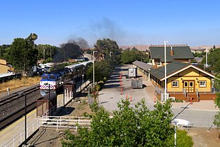
Pleasanton station is a train station in Pleasanton, California served by Altamont Corridor Express (ACE) trains. It is located northwest of downtown Pleasanton adjacent to the Alameda County Fairgrounds. The station has a single side platform on the single track of the Union Pacific Railroad Oakland Subdivision.
Livermore is a train station in downtown Livermore, California.

Vasco Road station is an ACE station on Vasco Road in eastern Livermore, California. The station mainly serves the workers of Lawrence Livermore National Laboratory, Sandia National Laboratory and the surrounding industrial and office parks in eastern Livermore in addition to commuters from Livermore headed to job centers in the Silicon Valley to the southwest.
Throughout the history of Bay Area Rapid Transit, there have been plans to extend service to other areas.
The Western Pacific Railroad (1862–1870) was formed in 1862 to build a railroad from Sacramento, California, to the San Francisco Bay, the westernmost portion of the First transcontinental railroad. After the completion of the railroad from Sacramento to Alameda Terminal on September 6, 1869, and then the Oakland Pier on November 8, 1869, which was the Pacific coast terminus of the transcontinental railroad, the Western Pacific Railroad was absorbed in 1870 into the Central Pacific Railroad.
Vasco Road is a roadway over the Diablo Range that connects Livermore and Brentwood, California. Although it is not part of the California State Highway system, it is the principal north–south commuter route serving eastern Alameda and Contra Costa counties. The two counties are each responsible for maintaining the portion of the road within their boundaries.
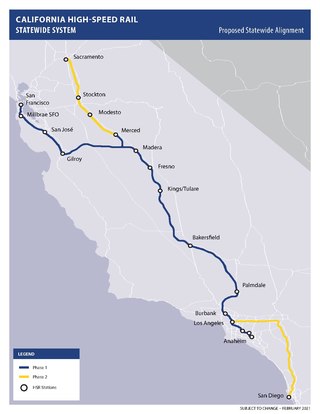
The California High-Speed Rail system will be built in two major phases. Phase I, about 520 miles (840 km) long using high-speed rail through the Central Valley, will connect San Francisco to Los Angeles. In Phase 2, the route will be extended in the Central Valley north to Sacramento, and from east through the Inland Empire and then south to San Diego. The total system length will be about 800 miles (1,300 km) long. Phase 2 currently has no timeline for completion.

Valley Link is a proposed 26-mile-long (42 km) commuter rail service in Northern California, which seeks to connect the rapid transit Bay Area Rapid Transit (BART) system in the San Francisco Bay Area with the northern San Joaquin Valley via the Tri-Valley region. Since 1997, BART's Blue Line's eastern terminus is at Dublin/Pleasanton station on the border of Dublin and Pleasanton. Valley Link seeks to extend rail service east from here into the northern San Joaquin Valley over Altamont Pass and to help alleviate traffic congestion and reducing greenhouse gas emissions on Interstate 580 (I-580). The project resulted from various failed proposals to extend the Blue Line east to Livermore.
North Lathrop station is a planned Altamont Corridor Express station in Lathrop, California – the second to be constructed in the city. It was expected to open to revenue service in 2023 as part of the first phase of ACE's expansion to Merced, but was later delayed to 2027.
Isabel station is a proposed commuter rail train station in Livermore, California. It is expected to open in 2027 as a stop for Valley Link. The station's parking lot and bus bays are located on the north side of East Airway Boulevard while the platforms and rails are located in the median strip of Interstate 580 just east of Isabel Avenue.