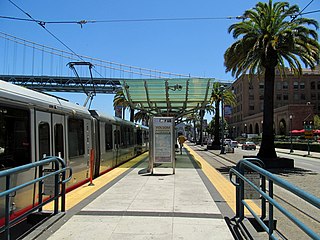
The Embarcadero and Folsom station is a Muni Metro light rail station located in the median of The Embarcadero between Folsom Street and Harrison Street in the Rincon Hill area of San Francisco, California. Muni Metro trains use a high-level island platform, while historic streetcars use a pair of side platforms at the southeast end of the station next to the Harrison Street grade crossing.

Brannan and The Embarcadero station is a Muni Metro light rail station located in the median of The Embarcadero south of Brannan Street in the South Beach area of San Francisco, California. Muni Metro trains use a high-level island platform, while historic streetcars use a pair of side platforms at the south end of the station.
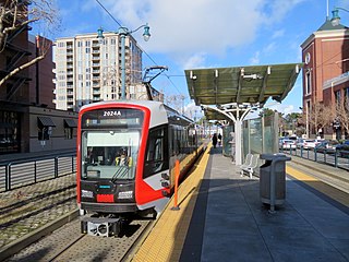
2nd and King station is a Muni Metro light rail station located in the median of King Street near Second Street in the China Basin neighborhood of San Francisco, California. It is adjacent to Oracle Park. Muni Metro trains use a high-level island platform, while historic streetcars use a pair of side platforms just to the south.

Mission Rock station is a light rail station on the Muni Metro T Third Street line, located in the median of Third Street at Mission Rock Street in the Mission Bay neighborhood of San Francisco, California. The station opened with the T Third Street line on January 13, 2007. It has two side platforms; the northbound platform is north of Mission Rock Street, and the southbound platform south of Mission Rock Street, which allows trains to pass through the intersection before stopping at the station.

UCSF/Chase Center station is a light rail station on the Muni Metro T Third Street line, located in the median of Third Street at South Street in the Mission Bay neighborhood of San Francisco, California. The station serves the UCSF Mission Bay campus and the Chase Center arena. The station opened with the T Third Street line on January 13, 2007. Its original configuration had two side platforms; the northbound platform was north of South Street, and the southbound platform south of South Street. The station was closed from November 2018 to August 2019 for conversion to a single island platform to better serve the Chase Center which opened in September 2019.

UCSF Medical Center station is a light rail station on the Muni Metro T Third Street line, located in the median of Third Street at Mariposa Street in the Mission Bay neighborhood of San Francisco, California. The station serves the UCSF Medical Center and the larger UCSF Mission Bay campus. The station opened with the T Third Street line on January 13, 2007. It has two side platforms; the northbound platform is north of Mariposa Street, and the southbound platform south of Mariposa Street, which allows trains to pass through the intersection before stopping at the station.

20th Street station is a light rail station on the Muni Metro T Third Street line in the Dogpatch neighborhood of San Francisco, California. The station opened with the T Third Street line on January 13, 2007. It has two side platforms; the northbound platform is north of 20th Street, and the southbound platform south of 20th Street, so that trains can pass through the intersection before the station stop.

23rd Street station is a light rail station on the Muni Metro T Third Street line, located in the median of Third Street in the Dogpatch neighborhood of San Francisco, California. The station opened with the T Third Street line on January 13, 2007. It has two side platforms; the northbound platform is north of 23rd Street, and the southbound platform south of 23rd Street, so that trains can pass through the intersection before the station stop.

Marin Street station is a light rail station on the Muni Metro T Third Street line, located in the median of 3rd Street one block south of Cesar Chavez Street in the Bayview neighborhood of San Francisco, California. The station opened with the T Third Street line on April 7, 2007. It has two side platforms; the northbound platform is south of South Street, and the southbound platform north of Marin Street.
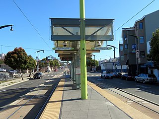
Hudson/Innes station is a light rail station on the Muni Metro T Third Street line in the Bayview neighborhood of San Francisco, California. The station opened with the T Third Street line on January 13, 2007. It has a single island platform located in the median of Third Street between Hudson Avenue and Innes Avenue, with access from crosswalks at both streets.

Kirkwood/La Salle station is a light rail station on the Muni Metro T Third Street line in the Bayview neighborhood of San Francisco, California. The station opened with the T Third Street line on January 13, 2007. It has a single island platform located in the median of Third Street between Kirkwood Avenue and La Salle Avenue, with access from crosswalks at both streets.

Oakdale/Palou station is a light rail station on the Muni Metro T Third Street line in the Bayview neighborhood of San Francisco, California. The station opened with the T Third Street line on January 13, 2007. It has a single island platform located in the median of Third Street between Oakdale Avenue and Palou Avenue, with access from crosswalks at both streets.

Revere/Shafter station is a light rail station on the Muni Metro T Third Street line in the Bayview neighborhood of San Francisco, California. The station opened with the T Third Street line on January 13, 2007. It has a single island platform located in the median of Third Street between Revere Avenue and Shafter Avenue, with access from crosswalks at both streets.

Williams station is a light rail station of the San Francisco Municipal Railway's Muni Metro system located in the median of Third Street at Williams and Van Dyke Avenues in Bayview, San Francisco, California, United States. The station opened along with the T Third Street line on January 13, 2007. It has two side platforms; the northbound platform is north of Williams Avenue, and the southbound platform south of Williams Avenue, so that trains can pass through the intersection before the station stop. A wye for trains to reverse directions is located two blocks south at Armstrong Avenue, allowing Williams station to be the terminus of short turn trains when necessary.
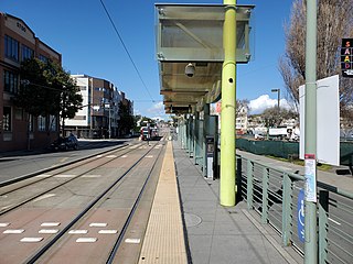
Carroll station is a light rail station on the Muni Metro T Third Street line, located in the median of Third Street in the Bayview neighborhood of San Francisco, California. The station opened with the T Third Street line on January 13, 2007. It has two side platforms; the northbound platform is north of Carroll Avenue, and the southbound platform south of Carroll Avenue, so that trains can pass through the intersection before the station stop.

Gilman/Paul station is a light rail station on the Muni Metro T Third Street line, located in the median of Third Street in the Bayview neighborhood of San Francisco, California. The station opened with the T Third Street line on January 13, 2007. It has two side platforms; the northbound platform is north of Gilman Avenue/Paul Avenue, and the southbound platform to the south, so that trains can pass through the intersection before the station stop.

Le Conte station is a light rail station on the Muni Metro T Third Street line in the Bayview neighborhood of San Francisco, California. The station opened with the T Third Street line on January 13, 2007. It has a single island platform located in the median of Third Street south of Le Conte Avenue. The station is located in an open cut between the travel lanes of Third Street, which rise south of Le Conte Avenue to pass over Candlestick Hill and the Bayshore Freeway. South of the station, the line also rises to pass over the hill and highway.
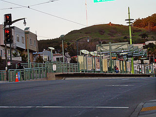
Arleta station is a light rail station on the Muni Metro T Third Street line in the Visitacion Valley neighborhood of San Francisco, California on the south slope of Candlestick Hill. The station opened with the T Third Street line on January 13, 2007. It has a single island platform located in the median of Bayshore Boulevard between Arleta Avenue and Blanken Avenue, with access from crosswalks at both streets.

Duboce and Church is a light rail stop on the Muni Metro J Church and N Judah lines, located in the Duboce Triangle neighborhood of San Francisco, California. Just east of the station, the two lines enter the Market Street subway. The stop originally opened with the 22 Fillmore line in 1895. The station has complex layout with two side platforms in the middle of Duboce Avenue for the N Judah, one side platform in the middle of Church Street for northbound J Church trains entering the Market Street subway, and two mini-high platforms at the subway portal which provides access to both lines for people with disabilities.

Right Of Way/Ocean station is a light rail stop on the Muni Metro M Ocean View line, located in the Merced Manor neighborhood of San Francisco, California. It opened in 1925 with the first phase of the line. The station is located where the line's private right-of-way crosses Ocean Avenue, with narrow side platforms located on the near side of the grade crossing. The northbound platform is across the tracks from the southbound platform of Right Of Way/Eucalyptus station. The stop is not accessible to people with disabilities.


