
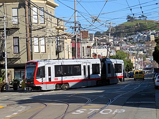
The K Ingleside is a hybrid light rail/streetcar line of the Muni Metro system in San Francisco, California. It mainly serves the West Portal and Ingleside neighborhoods. The line opened on February 3, 1918, and was the first line to use the Twin Peaks Tunnel.

The Market Street Railway Company was a commercial streetcar and bus operator in San Francisco. The company was named after the famous Market Street of that city, which formed the core of its transportation network. Over the years, the company was also known as the Market Street Railroad Company, the Market Street Cable Railway Company and the United Railroads of San Francisco. Once the largest transit operator in the city, the company folded in 1944 and its assets and services were acquired by the city-owned San Francisco Municipal Railway. Many of the former routes continue to exist into the 2020s, but served by buses.

The Geary Street, Park and Ocean Railway was a street railway in San Francisco, California, United States.

San Francisco State University station is a light rail station on the Muni Metro M Ocean View line, located adjacent to San Francisco State University and the Parkmerced neighborhood in the median of 19th Avenue in San Francisco, California. It opened in 1925 with the first phase of the line and was rebuilt with a high-level island platform in 1993. The station is accessible.

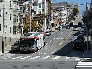
38 Geary is a bus line operated by the San Francisco Municipal Railway (Muni). Together with the limited service routes that share the number, the 38R Geary Rapid, 38AX Geary 'A' Express, and 38BX Geary 'B' Express, the Geary Boulevard corridor makes up Muni's busiest thoroughfare.
Stonestown station is a light rail station on the Muni Metro M Ocean View line, located in the median of 19th Avenue adjacent to Stonestown Galleria and the Lakeside neighborhood in San Francisco, California. It opened in 1925 with the first phase of the line and was rebuilt with a high-level island platform in 1993. The station is accessible to people with disabilities.

Duboce and Church is a light rail stop on the Muni Metro J Church and N Judah lines, located in the Duboce Triangle neighborhood of San Francisco, California. Just east of the station, the two lines enter the Market Street subway. The stop originally opened with the 22 Fillmore line in 1895. The station has complex layout with two side platforms in the middle of Duboce Avenue for the N Judah, one side platform in the middle of Church Street for northbound J Church trains entering the Market Street subway, and two mini-high platforms at the subway portal which provides access to both lines for people with disabilities.
Church and 30th Street station is a one-way light rail stop on the Muni Metro J Church line, located in the Noe Valley neighborhood of San Francisco, California. The stop is only served by inbound trains; outbound trains stop further north at Day Street. The stop has no platforms, trains stop at marked poles and passengers cross a vehicle travel lanes to board trains. The stop is not accessible to people with disabilities.

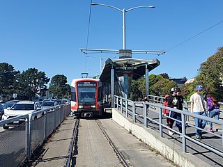
Broad and Plymouth station is a light rail stop on the Muni Metro M Ocean View line, located in the Ingleside neighborhood of San Francisco, California. The station has transit bulbs which extend the sidewalk of Broad Street, to meet trains like a side platform, allowing passengers to board or depart from trains. The stops are located just before trains cross Plymouth Avenue and include accessible mini-high platforms.

The San Francisco trolleybus system forms part of the public transportation network serving San Francisco, in the state of California, United States. Opened on October 6, 1935, it presently comprises 15 lines and is operated by the San Francisco Municipal Railway, commonly known as Muni, with around 300 trolleybuses. In San Francisco, these vehicles are also known as "trolley coaches", a term that was the most common name for trolleybuses in the United States in the middle decades of the 20th century. In 2023, the system had a ridership of 42,240,000, or about 132,300 per weekday as of the fourth quarter of 2023.

33 Ashbury/18th Street is a trolleybus line operated by the San Francisco Municipal Railway. The route is descendant from the first trolleybus service to open in San Francisco.

14 Mission is a trolleybus line operated by the San Francisco Municipal Railway. It serves Mission Street between the Ferry Plaza and Daly City.

1 California is a trolleybus line operated by the San Francisco Municipal Railway (Muni). It provides service between the Richmond District and Financial District along California Street.
41 Union is a trolleybus line operated by the San Francisco Municipal Railway (Muni). It connects South of Market, the Financial District, Chinatown, North Beach, Russian Hill, and Cow Hollow.

24 Divisadero is a trolleybus line operated by the San Francisco Municipal Railway (Muni). Most of its north–south route takes it along Divisadero Street and Castro Street.

5 Fulton is a trolleybus line operated by the San Francisco Municipal Railway (Muni). It is one of several routes which connects the Outer Richmond to the Financial District.

31 Balboa is a trolleybus line operated by the San Francisco Municipal Railway. It is one of several routes operating between the Financial District and the Richmond District.

3 Jackson is a suspended trolleybus line operated by the San Francisco Municipal Railway.
45 Union/Stockton is a trolleybus line operated by the San Francisco Municipal Railway. It connects Cow Hollow to South of Market via Russian Hill, Chinatown, and the Financial District.
