
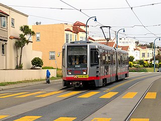
The L Taraval is a hybrid light rail/streetcar line of the Muni Metro system in San Francisco, California, mainly serving the Parkside District. While many streetcar lines were converted to bus lines after World War II, the L Taraval remained a streetcar line due to its use of the Twin Peaks Tunnel.

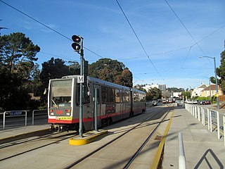
The M Ocean View is a light rail line that is part of the Muni Metro system in San Francisco, California. Named after the Oceanview neighborhood, it runs between San Jose and Geneva and Embarcadero station, connecting Oceanview, San Francisco State University, and Stonestown Galleria with the city center. The line opened on October 6, 1925.

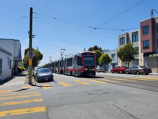
The K Ingleside is a light rail line of the Muni Metro system in San Francisco, California. It mainly serves the West Portal and Ingleside neighborhoods. The line opened on February 3, 1918, and was the first line to use the Twin Peaks Tunnel.

Balboa Park station is a Bay Area Rapid Transit (BART) station and Muni Metro complex in the Mission Terrace neighborhood of San Francisco, California, located near the eponymous Balboa Park. It is an intermodal hub served by four BART routes, three Muni Metro lines, and a number of Muni bus routes. The station complex also includes two rail yards, Cameron Beach Yard and Green Light Rail Center, where Muni maintains Muni Metro trains and heritage streetcars. BART uses a below-grade island platform on the west side of the complex; Muni Metro routes use several smaller side platforms located on surface-level rail loops around the yards.
St. Francis Circle is a light rail stop on the Muni Metro K Ingleside and M Ocean View lines, located in the St. Francis Wood neighborhood of San Francisco, California. It opened around 1907 when the United Railroads (URR) expanded its Ocean Avenue line west to Ocean Beach; Muni service followed with the K in 1918 and the M in 1925.

Junipero Serra and Ocean is a light rail stop on the Muni Metro K Ingleside line, located in the St. Francis Wood neighborhood of San Francisco, California. It originally opened around 1896 on the United Railroads 12 line; K Ingleside service began in 1919.
Ocean and San Leandro is a light rail stop on the Muni Metro K Ingleside line, located between the Balboa Terrace and Ingleside Terrace neighborhoods of San Francisco, California. It originally opened around 1896 on the United Railroads (12) line; K Ingleside service began in 1919. The stop consists of two side platforms, with the eastbound (outbound) platform located on Ocean Avenue west of the intersection with San Leandro Way, and vice versa.

Ocean and Aptos is a light rail stop on the Muni Metro K Ingleside line, located between the Balboa Terrace and Ingleside Terrace neighborhoods of San Francisco, California. The stop consists of two side platforms, with the eastbound (outbound) platform located on Ocean Avenue west of the intersection with Aptos Avenue, and vice versa. It originally opened around 1896 on the United Railroads 12 line; K Ingleside service began in 1919.

Ocean and Westgate (inbound) and Ocean and Cerritos (outbound) were a pair of one-way light rail stops on the Muni Metro K Ingleside line, located between the Mount Davidson and Ingleside Terrace neighborhoods of San Francisco, California. The stops consisted of one side platform each, with the eastbound (outbound) platform located on Ocean Avenue west of the intersection with Westgate Drive and Cerritos Avenue, and the westbound (inbound) platform located east of the intersection. They originally opened around 1896 on the United Railroads 12 line; K Ingleside service began in 1919. The stops were closed on September 28, 2024.

Ocean and Fairfield (inbound) and Ocean and Victoria (outbound) are a pair of one-way light rail stops on the Muni Metro K Ingleside line, located between the Mount Davidson and Ingleside Terrace neighborhoods of San Francisco, California. The stops consist of one side platform each, with the eastbound (outbound) platform located on Ocean Avenue west of the intersection with Victoria Street and the westbound (inbound) located east of the intersection and just west of Fairfield Way. They originally opened in 1895 on the United Railroads 12 line; K Ingleside service began in 1919.

Ocean and Dorado (inbound) and Ocean and Jules (outbound) are a pair of one-way light rail stops on the Muni Metro K Ingleside line, located between the Mount Davidson and Ingleside neighborhoods of San Francisco, California. The stops consist of one side platform each, with the eastbound (outbound) platform located on Ocean Avenue west of the intersection with Dorado Terrace and Jules Avenue, and the westbound (inbound) platform located east of the intersection. It originally opened in 1895 on the United Railroads 12 line; K Ingleside service began in 1919.

Ocean and Miramar is a light rail stop on the Muni Metro K Ingleside line, located between the Westwood Park and Ingleside neighborhoods of San Francisco, California, United States. The stop consists of two side platforms, with the eastbound (outbound) platform located on Ocean Avenue west of the intersection with Miramar Avenue and the westbound (inbound) platform located east of the intersection. It originally opened in 1895 on the United Railroads 12 line; K Ingleside service began in 1919.

Ocean and Lee station is a light rail stop on the Muni Metro K Ingleside line, located between the Westwood Park and Ingleside neighborhoods of San Francisco, California. The stop consists of two side platforms, with the eastbound (outbound) platform located on Ocean Avenue west of the intersection with Lee Street, and vice versa.

19th Avenue and Randolph station is a light rail stop on the Muni Metro M Ocean View line, located in the Ingleside neighborhood of San Francisco, California. The stop has no platforms; trains stop at marked poles before crossing Randolph Street and passengers cross a parking lane on 19th Avenue to board trains. The stop is not accessible.

Broad and Orizaba / Orizaba and Broad stations are a pair of light rail stops on the Muni Metro M Ocean View line, located in the Ingleside neighborhood of San Francisco, California. The inbound stop is located on Broad Street at Orizaba Avenue, while outbound trains stop on Orizaba Avenue at Broad Street. The stop has no platforms; trains stop at marked poles and passengers cross a vehicle travel lane to board or depart trains. The stop is not accessible.
Broad and Capitol station is a light rail stop on the Muni Metro M Ocean View line, located in the Ingleside neighborhood of San Francisco, California. The stop has no platforms; trains stop at marked poles before crossing Capitol Avenue and passengers cross a vehicle travel lane on Broad Street to board trains. The stop is not accessible.

Broad and Plymouth station is a light rail stop on the Muni Metro M Ocean View line, located in the Ingleside neighborhood of San Francisco, California. The station has transit bulbs which extend the sidewalk of Broad Street, to meet trains like a side platform, allowing passengers to board or depart from trains. The stops are located just before trains cross Plymouth Avenue and include accessible mini-high platforms.

San Jose and Lakeview station is a light rail stop on the Muni Metro M Ocean View line, located in the Ingleside neighborhood of San Francisco, California. The stop has very small traffic islands where trains stop before crossing Lakeview Avenue; most passengers cross a vehicle travel lane on San Jose Avenue to board or depart trains. The stop is not accessible. It opened with the extension of the line to Balboa Park station on August 30, 1980.
San Jose and Mount Vernon station was a light rail stop on the Muni Metro M Ocean View line, located in the Ingleside neighborhood of San Francisco, California. The station had two side platforms in the middle of San Jose Avenue; the inbound platform is located on a bridge over Interstate 280. The platforms were not accessible.


