Ocean and Lee station

Last updated
Ocean and Lee
K Ingleside logo.svg
Inbound train at Ocean and Lee, January 2018.JPG
An inbound train at Ocean and Lee in January 2018
General information
LocationOcean Avenue at Lee Avenue
San Francisco, California
Coordinates 37°43′25″N122°27′15″W / 37.72349°N 122.45410°W / 37.72349; -122.45410
Platforms2 side platforms
Tracks2
ConnectionsAiga bus trans.svg Muni: 8, 8BX, 29, 43, 49
Construction
AccessibleYes
History
OpenedDecember 4, 1895 (1895-12-04)
Services
Preceding station BSicon LOGO SFmuni.svg Muni Following station
Ocean and Miramar
towards Embarcadero
K Ingleside City College
towards Balboa Park
Location
Ocean and Lee station

Ocean and Lee station is a light rail stop on the Muni Metro K Ingleside line, located between the Westwood Park and Ingleside neighborhoods of San Francisco, California. The stop consists of two side platforms, with the eastbound (outbound) platform located on Ocean Avenue west of the intersection with Lee Street, and vice versa.

Contents

It originally opened in 1895 on the United Railroads 12 line. K Ingleside service then began in 1945. In 1952, the site became known as Phelan Loop after a loop was constructed for the K line, and a separate busway for the 12 line (which was converted to bus in 1948), north of Ocean Avenue and west of Phelan Avenue. Phelan Loop was then retired for streetcar service in 1981 and for bus service in 2013, replaced by the current Ocean and Lee Muni Metro platforms and the nearby City College bus terminal, respectively.

The station is also served by bus routes 8, 8BX (a weekday peak hours express service), 29, 43 and 49, most of which stop at the nearby City College terminal. Additionally, the KT Bus, K Owl and 91 Owl bus routes provide service along the K Ingleside line during the early morning and late night hours respectively when trains do not operate. [1]

History

A Muni streetcar at Ocean and Lee nearing Phelan Loop in 1967 Muni 1031 as K Ingleside at Ocean and Lee, August 1967.jpg
A Muni streetcar at Ocean and Lee nearing Phelan Loop in 1967
Muni buses at Phelan Loop around 2002 Phelan Loop, circa 2002.jpg
Muni buses at Phelan Loop around 2002

The private Market Street Railway opened a branch — built in just six days — of its Mission Street line along Ocean Avenue to Victoria Street on December 4, 1895 to serve the new Ingleside Racetrack. [2] The line was extended to the Ingleside House (where Ocean Avenue now meets Junipero Serra Boulevard) shortly thereafter. [3] The 1906 earthquake damaged many cable car and streetcar lines; the URR resumed service on the Ocean Avenue (12) line on May 6, 1906. [4]

On November 25, 1918, the city and the struggling URR signed the "Parkside Agreements", which allowed Muni streetcars to use URR trackage on Junipero Serra Boulevard, Ocean Avenue, and Taraval Street, in exchange for a cash payment and shared maintenance costs. [5] The K Ingleside line was extended south on Junipero Serra Boulevard and east on Ocean to Ocean and Miramar on February 21, 1919. Miramar was the terminus of the line until May 18, 1919, when it was extended east on Ocean Avenue and south on Brighton Avenue to Grafton Avenue. [4]

The city purchased the private company (renamed Market Street Railway in 1921) in 1944; route 12 service was removed from Ocean Avenue on April 8, 1945, leaving just the K Ingleside. [4] On April 8, 1945, route 12 service was removed from Ocean Avenue, while every other K Ingleside car was extended on Ocean Avenue and Onondaga Street to Mission Street to provide a direction connection to route 14. [4] In 1952, Muni constructed a loop for the K with a separate busway for the 12 (converted to bus in 1948) on city property north of Ocean Avenue and west of Phelan Avenue, adjacent to the then-new City College. [5] The Brighton Avenue trackage was retired and replaced with the new Phelan Loop on May 18, 1952; the alternate service to Mission Street was cut back to the loop on October 10, 1952. [4]

In the 1970s, Muni rebuilt the non-revenue trackage for regular service so that K Ingleside service could be extended to the new Balboa Park station. The first revenue service to Balboa Park was on April 23, 1979, although service past Phelan Loop did not run at all times until March 17, 1981. Phelan Loop was then retired for streetcar service, replaced with platforms on Ocean Avenue at Lee Street. [4] However, Muni buses continued using the bus loop because Balboa Park station did not include a bus terminal. By the early 2000s, the loop was part of a section of Ocean Avenue deemed "bleak and uninteresting", in contrast to the commercial district to the west. [6] In 2001, as part of a planning process for the Balboa Park area, the city proposed to build a housing development and public open space on the loop parcel, with buses using a new loop behind an adjacent fire station closer to Phelan Avenue. [7]

The line was closed and replaced by buses from February 2001 to June 7, 2003 for the Ocean Avenue Reconstruction and Improvement Project, a major street repaving and utility replacement project. Muni built new side platforms (traffic islands) on the near side of the cross street, with a short mini-high platform providing access to people with disabilities. [8] In July 2010, Muni received a $6.8 million federal grant to fund the loop relocation. [9] The new loop, City College Terminal, opened on May 6, 2013 for the 8/8BX and 49 routes, which enter the loop from Ocean Avenue and exit onto Phelan Avenue. [10] Housing was soon built on the old loop site; the new open space, Unity Plaza, opened next to the loop in October 2016. [11]

In 2023, the SFMTA began planning work on the K Ingleside Rapid Project, which is intended to increase capacity and reduce travel time on the Ocean Avenue portion of the line. No significant changes are proposed at Lee, as the platforms are already long enough for two-car trains. [12] As of January 2024, "quick-build" implementation of some project elements is planned for early 2024, with construction of the full project taking place from 2027 to 2029. [13]

Related Research Articles

<span class="mw-page-title-main">L Taraval</span> San Francisco light rail line

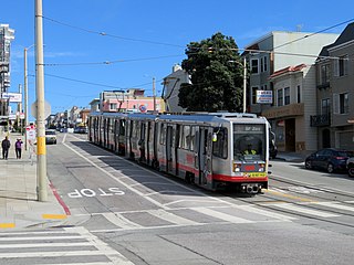
The L Taraval is a hybrid light rail/streetcar line of the Muni Metro system in San Francisco, California, mainly serving the Parkside District. Since 2021, the line has been suspended and replaced by buses until the end of 2024 for an improvement project along Taraval Street.

<span class="mw-page-title-main">M Ocean View</span> San Francisco light rail line

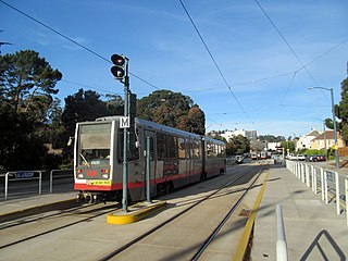
The M Ocean View is a light rail line that is part of the Muni Metro system in San Francisco, California. Named after the Oceanview neighborhood, it runs between San Jose and Geneva and Embarcadero station, connecting Oceanview, San Francisco State University, and Stonestown Galleria with the city center. The line opened on October 6, 1925.
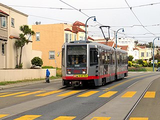
<span class="mw-page-title-main">K Ingleside</span> San Francisco light rail line

The K Ingleside is a hybrid light rail/streetcar line of the Muni Metro system in San Francisco, California. It mainly serves the West Portal and Ingleside neighborhoods. The line opened on February 3, 1918, and was the first line to use the Twin Peaks Tunnel.

<span class="mw-page-title-main">J Church</span> San Francisco light rail line

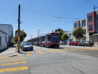
The J Church is a hybrid light rail/streetcar line of the Muni Metro system in San Francisco, California. The line runs between Embarcadero station and Balboa Park station through Noe Valley. Opened on August 11, 1917, it is the oldest and has the lowest ridership of all of the Muni Metro lines.

<span class="mw-page-title-main">Balboa Park station</span> Transit station in San Francisco, California, US

Balboa Park station is a Bay Area Rapid Transit (BART) station and Muni Metro complex in the Mission Terrace neighborhood of San Francisco, California, located near the eponymous Balboa Park. It is an intermodal hub served by four BART routes, three Muni Metro lines, and a number of Muni bus routes. The station complex also includes two rail yards, Cameron Beach Yard and Green Light Rail Center, where Muni maintains Muni Metro trains and heritage streetcars. BART uses a below-grade island platform on the west side of the complex; Muni Metro routes use several smaller side platforms located on surface-level rail loops around the yards.

<span class="mw-page-title-main">T Third Street</span> San Francisco light rail line

The T Third Street is a Muni Metro light rail line in San Francisco, California. It runs along the east side of San Francisco from Sunnydale to Chinatown, traveling in the median of Third Street for most of its length before entering the Central Subway as it approaches downtown. The line serves 22 stations, all of which are accessible. Most of the surface portion of the line runs in dedicated median lanes, though two portions operate in mixed traffic.

<span class="mw-page-title-main">St. Francis Circle station</span>

St. Francis Circle is a light rail stop on the Muni Metro K Ingleside and M Ocean View lines, located in the St. Francis Wood neighborhood of San Francisco, California. It opened around 1907 when the United Railroads (URR) expanded its Ocean Avenue line west to Ocean Beach; Muni service followed with the K in 1918 and the M in 1925.

<span class="mw-page-title-main">Junipero Serra and Ocean station</span>

Junipero Serra and Ocean is a light rail stop on the Muni Metro K Ingleside line, located in the St. Francis Wood neighborhood of San Francisco, California. It originally opened around 1896 on the United Railroads 12 line; K Ingleside service began in 1919.

<span class="mw-page-title-main">Ocean and San Leandro station</span>

Ocean and San Leandro is a light rail stop on the Muni Metro K Ingleside line, located between the Balboa Terrace and Ingleside Terrace neighborhoods of San Francisco, California. It originally opened around 1896 on the United Railroads (12) line; K Ingleside service began in 1919. The stop consists of two side platforms, with the eastbound (outbound) platform located on Ocean Avenue west of the intersection with San Leandro Way, and vice versa.

<span class="mw-page-title-main">Ocean and Aptos station</span>

Ocean and Aptos is a light rail stop on the Muni Metro K Ingleside line, located between the Balboa Terrace and Ingleside Terrace neighborhoods of San Francisco, California. The stop consists of two side platforms, with the eastbound (outbound) platform located on Ocean Avenue west of the intersection with Aptos Avenue, and vice versa. It originally opened around 1896 on the United Railroads 12 line; K Ingleside service began in 1919.

<span class="mw-page-title-main">Ocean and Westgate / Ocean and Cerritos stations</span>

Ocean and Westgate (inbound) and Ocean and Cerritos (outbound) are a pair of one-way light rail stops on the Muni Metro K Ingleside line, located between the Mount Davidson and Ingleside Terrace neighborhoods of San Francisco, California. The stops consist of one side platform each, with the eastbound (outbound) platform located on Ocean Avenue west of the intersection with Westgate Drive and Cerritos Avenue, and vice versa. They originally opened around 1896 on the United Railroads 12 line; K Ingleside service began in 1919.

<span class="mw-page-title-main">Ocean and Fairfield / Ocean and Victoria stations</span>

Ocean and Fairfield (inbound) and Ocean and Victoria (outbound) are a pair of one-way light rail stops on the Muni Metro K Ingleside line, located between the Mount Davidson and Ingleside Terrace neighborhoods of San Francisco, California. The stops consist of one side platform each, with the eastbound (outbound) platform located on Ocean Avenue west of the intersection with Victoria Street and the westbound (inbound) located east of the intersection and just west of Fairfield Way. They originally opened in 1895 on the United Railroads 12 line; K Ingleside service began in 1919.

<span class="mw-page-title-main">Ocean and Dorado / Ocean and Jules stations</span>

Ocean and Dorado (inbound) and Ocean and Jules (outbound) are a pair of one-way light rail stops on the Muni Metro K Ingleside line, located between the Mount Davidson and Ingleside neighborhoods of San Francisco, California. The stops consist of one side platform each, with the eastbound (outbound) platform located on Ocean Avenue west of the intersection with Dorado Terrace and Jules Avenue, and the westbound (inbound) platform located east of the intersection. It originally opened in 1895 on the United Railroads 12 line; K Ingleside service began in 1919.

<span class="mw-page-title-main">Ocean and Miramar station</span>

Ocean and Miramar is a light rail stop on the Muni Metro K Ingleside line, located between the Westwood Park and Ingleside neighborhoods of San Francisco, California. The stop consists of two side platforms, with the eastbound (outbound) platform located on Ocean Avenue west of the intersection with Miramar Avenue and the westbound (inbound) platform located east of the intersection. It originally opened in 1895 on the United Railroads 12 line; K Ingleside service began in 1919.

<span class="mw-page-title-main">Ocean Avenue/CCSF Pedestrian Bridge station</span>

Ocean Avenue/CCSF Pedestrian Bridge station is a light rail station on the Muni Metro K Ingleside line, located between the Sunnyside and Ingleside neighborhoods of San Francisco, California adjacent to the City College of San Francisco (CCSF) campus. The stop consists of two side platforms in the median of Ocean Avenue, with stairs to a concrete footbridge that connects the campus to Geneva Avenue. It opened in 1979 with the extension of the line to Balboa Park station; it was previously served by the United Railroads 12 line from 1895 to 1945, and the K from 1945 to 1952.

<span class="mw-page-title-main">Taraval and 22nd Avenue / Taraval and 23rd Avenue stations</span>

Taraval and 22nd Avenue / Taraval and 23rd Avenue stations are a pair of light rail stops on the Muni Metro L Taraval line, located in the Parkside neighborhood of San Francisco, California. The eastbound stop is located on Taraval Street and 22nd Avenue, while westbound trains stop on Taraval Street at 23rd Avenue.

<span class="mw-page-title-main">Taraval and 30th Avenue station</span>

Taraval and 30th Avenue is a light rail stop on the Muni Metro L Taraval line, located in the Parkside neighborhood of San Francisco, California. The station opened with the first section of the L Taraval line on April 12, 1919; irregular shuttle service had run on a United Railroads line since around 1910.

<span class="mw-page-title-main">19th Avenue and Randolph station</span>

19th Avenue and Randolph station is a light rail stop on the Muni Metro M Ocean View line, located in the Ingleside neighborhood of San Francisco, California. The stop has no platforms; trains stop at marked poles before crossing Randolph Street and passengers cross a parking lane on 19th Avenue to board trains. The stop is not accessible.

<span class="mw-page-title-main">Broad and Capitol station</span>

Broad and Capitol station is a light rail stop on the Muni Metro M Ocean View line, located in the Ingleside neighborhood of San Francisco, California. The stop has no platforms; trains stop at marked poles before crossing Capitol Avenue and passengers cross a vehicle travel lane on Broad Street to board trains. The stop is not accessible.

<span class="mw-page-title-main">Broad and Plymouth station</span> Light rail stop in San Francisco, California, US

Broad and Plymouth station is a light rail stop on the Muni Metro M Ocean View line, located in the Ingleside neighborhood of San Francisco, California. The station has transit bulbs which extend the sidewalk of Broad Street, to meet trains like a side platform, allowing passengers to board or depart from trains. The stops are located just before trains cross Plymouth Avenue and include accessible mini-high platforms.

References

  1. "Muni Service Map". SFMTA. July 9, 2022. Retrieved December 2, 2022.
  2. Rice, Walter; Echeverria, Emiliano (2002). When Steam Ran on the Streets of San Francisco. Harold E. Cox. p. 66.
  3. Southern Pacific Company (1897). "Guide Map Of The City of San Francisco". H.S. Crocker Co. via David Rumsey Map Collection.
  4. 1 2 3 4 5 6 Stindt, Fred A. (October 1990). San Francisco's Century of Street Cars. pp. 94, 189. ISBN   0-9615465-1-4.
  5. 1 2 Perles, Anthony (1981). The People's Railway: The History of the Municipal Railway of San Francisco. Interurban Press. pp. 74, 168, 188. ISBN   0916374424.
  6. "Chapter 2: Background". Balboa Park Station Area Plan (Draft for Public review) (PDF). San Francisco Planning Department. October 2002. p. 19.
  7. "Balboa Park Station: Workshop #4, Summary of Proposed Plan Concepts and Public Input". San Francisco Planning Department. September 2001.
  8. "Grand Re-Opening of Ocean Avenue Celebrated" (Press release). San Francisco Municipal Railway. June 20, 2003. Archived from the original on December 5, 2004.
  9. "SFMTA Awarded $6.8 Million in Federal Capital Funds For Phelan Loop Project" (Press release). City and County of San Francisco Office of the Mayor. July 9, 2010. Archived from the original on September 3, 2010.
  10. "Reconfigured Muni Phelan Loop Bus Terminal Facilitates Community Development" (Press release). San Francisco Municipal Transportation Agency. May 3, 2013.
  11. "Unity Plaza". San Francisco Municipal Transportation Agency.
  12. "K Ingleside Rapid Project Detail Boards" (PDF). San Francisco Municipal Transportation Agency. January 2024.
  13. "K Ingleside Rapid Project". San Francisco Municipal Transportation Agency. January 2024. Archived from the original on January 16, 2024.