
Contra Costa County is a county located in the U.S. state of California, in the East Bay of the San Francisco Bay Area. As of the 2020 United States Census, the population was 1,165,927. The county seat is Martinez. It occupies the northern portion of the East Bay region of the San Francisco Bay Area and is primarily suburban. The county's name refers to its position on the other side of the bay from San Francisco. Contra Costa County is included in the San Francisco–Oakland–Berkeley, CA Metropolitan Statistical Area.
Alamo is an unincorporated community and census-designated place (CDP) in Contra Costa County, California, in the United States. It is a suburb located in the San Francisco Bay Area's East Bay region, approximately 28 miles (45 km) east of San Francisco. Alamo is equidistant from the city of Walnut Creek and the incorporated town of Danville. As of the 2020 census, the population was 15,314.

Lafayette is a city in Contra Costa County, California, United States. As of 2020, the city's population was 25,391. It was named after the Marquis de Lafayette, a French military officer of the American Revolutionary War.
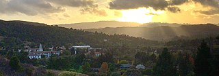
Moraga is a town in Contra Costa County, California, in the San Francisco Bay Area. The town is named in honor of Joaquín Moraga, member of the famed Californio family. As of 2020, Moraga had a total population of 16,870 people. Moraga is the home of Saint Mary's College of California.

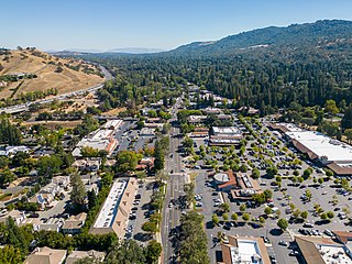
Walnut Creek is a city in Contra Costa County, California, United States, located in the East Bay region of the San Francisco Bay Area, about 16 miles east of the city of Oakland. Walnut Creek has a total population of 70,127 per the 2020 census, is located at the junction of the highways from Sacramento and San Jose (I-680) and San Francisco/Oakland (SR-24), and is accessible by BART. The city shares its borders with Clayton, Lafayette, Alamo, Pleasant Hill, and Concord.

Interstate 680 (I-680) is a north–south auxiliary Interstate Highway in Northern California. It curves around the eastern cities of the San Francisco Bay Area from San Jose to I-80 at Fairfield, bypassing cities along the eastern shore of San Francisco Bay such as Oakland and Richmond while serving others more inland such as Pleasanton and Concord.
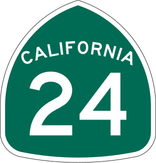
State Route 24 is a heavily traveled east–west state highway in the U.S. state of California that serves the eastern side of the San Francisco Bay Area. A freeway throughout its entire length, it runs from the Interstate 580/Interstate 980 interchange in Oakland, and through the Caldecott Tunnel under the Berkeley Hills, to the Interstate 680 junction in Walnut Creek. It lies in Alameda County, where it is highly urban, and Contra Costa County, where it passes through wooded hillsides and suburbs. SR 24 is a major connection between the San Francisco–Oakland Bay Bridge/MacArthur Maze complex and the inland cities of the East Bay.
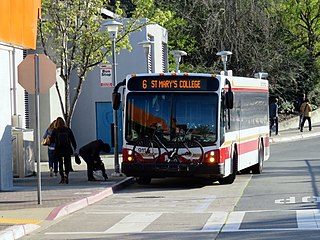
The County Connection is a Concord-based public transit agency operating fixed-route bus and ADA paratransit service in and around central Contra Costa County in the San Francisco Bay Area. Established in 1980 as a joint powers authority, CCCTA assumed control of public bus service within central Contra Costa first begun by Oakland-based AC Transit as it expanded into suburban Contra Costa County in the mid-1970s. In 2023, the system had a ridership of 2,661,400, or about 9,500 per weekday as of the second quarter of 2024.

The East Bay is the eastern region of the San Francisco Bay Area and includes cities along the eastern shores of the San Francisco Bay and San Pablo Bay. The region has grown to include inland communities in Alameda and Contra Costa counties. With a population of roughly 2.5 million in 2010, it is the most populous subregion in the Bay Area.
Acalanes Union High School District is a public high school district in Contra Costa County, located in the Bay Area of California. The district takes its name from Rancho Acalanes, an 1834 Mexican rancho grant which occupied much of the area from Orinda to Lafayette. The district operates four high schools.
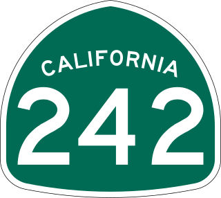
State Route 242 is an approximately 3.4-mile (5.5 km) state highway in Contra Costa County, California that links Interstate 680 at the Pleasant Hill–Concord border to State Route 4 in Concord. Along with Interstate 580, State Route 24, Interstate 680 and State Route 4, it serves as the most direct route between the San Francisco Bay Area and the Sacramento–San Joaquin River Delta region.
California's 10th congressional district is a congressional district in the U.S. state of California. Currently, the 10th district encompasses parts of the eastern San Francisco Bay Area. It is currently represented by Democrat Mark DeSaulnier.
California's 11th congressional district is a congressional district in the U.S. state of California and is represented by Nancy Pelosi.
Area code 925 is a telephone area code in the North American Numbering Plan for a northern part of the U.S. state of California. It was created in an area code split of area code 510 in 1998. The numbering plan area comprises the inland portions of the East Bay counties of Alameda and Contra Costa.
The Contra Costa County Board of Supervisors is the governing body for Contra Costa County, California, in the San Francisco Bay Area's East Bay region. Members of the Board of supervisors are elected from districts, based on their residence.
Rancho Laguna de Los Palos Colorados was a 13,316-acre (53.89 km2) Mexican land grant in the Berkeley Hills within present-day Contra Costa County, California.

The Walnut Creek mainstem is a 12.3-mile-long (19.8-kilometer) northward-flowing stream in northern California. The Walnut Creek watershed lies in central Contra Costa County, California and drains the west side of Mount Diablo and the east side of the East Bay Hills. The Walnut Creek mainstem is now mostly a concrete or earthen flood control channel until it reaches Pacheco Creek on its way to Suisun Bay. Walnut Creek was named for the abundant native Northern California walnut trees which lined its banks historically. The city of Walnut Creek, California was named for the creek when its post office was established in the 1860s.
Lamorinda is an American Viticultural Area (AVA) in the San Francisco Bay Area located due east of the Berkeley Hills in Contra Costa County encompassing the region around the cities of Lafayette, Moraga and Orinda. The name Lamorinda is a portmanteau from the names of the three locales defining the region: Lafayette, Moraga, and Orinda. The AVA is a sub-region within the existing San Francisco Bay AVA and the larger, multi-county Central Coast AVA stretching approximately 30,000 acres (47 sq mi) with 46 commercially-producing vineyards that cover approximately 139 acres (56 ha). The USDA plant hardiness zone for the AVA is 9b. The AVA was proposed as the growers in the area found the wider San Francisco Bay and Central Coast AVA titles too generic and not indicative of its terroir. The area was officially established March 25, 2016 by the Alcohol and Tobacco Tax and Trade Bureau (TTB) after reviewing the petition from Patrick L. Shabram, on behalf of the Lamorinda Wine Growers Association, proposing the establishment of the "Lamorinda" viticultural area.

Las Trampas Creek is a 12.37 mile long north-east flowing stream in Contra Costa County, California. Its watershed comprises an area of 17,238 acres. Its mean daily flow is approximately 15.4 cfs.

Tice Creek is a minor creek in Contra Costa County, California in the San Francisco Bay Area. It is approximately 4.1 miles (6.6 km) long. It is a tributary of Las Trampas Creek, which itself is a major tributary to Walnut Creek which in turn drains into Suisun Bay. The name comes from the surname of a settler family who settled in the Tice valley.
