Golden Gate Biosphere Network

Last updated
Golden Gate Biosphere Network
Mount Tamalpais Peak.jpg
Visitors enjoying the sunset atop Mount Tamalpais, a protected region within the Golden Gate Biosphere Network.
Relief map of California.png
Red pog.svg
Location of Golden Gate Biosphere
Usa edcp relief location map.png
Red pog.svg
Golden Gate Biosphere Network (the United States)
Nearest city San Francisco
Coordinates 37°48′N122°30′W / 37.8°N 122.5°W / 37.8; -122.5
Area27,976 sq mi (72,460 km2) [1]
Established1988 (1988) [2]
Governing body UNESCO
Website Golden Gate Biosphere

The Golden Gate Biosphere Network (GGBN or the Network) is a voluntary coalition of federal, state, and local government agencies, nonprofit organizations, universities, and private partners within the Golden Gate Biosphere region (along the western portion of the San Francisco Bay Area). The Network works towards protecting the biosphere region's biodiversity and conserving its natural resources to maintain the quality of life for people within the region. The Network has been part of the UNESCO Man and Biosphere Programme since 1988 and is part of the US Biosphere Network and EuroMAB. It is recognized by UNESCO due to the significant biodiversity of the region, as well as the Network's efforts to demonstrate and promote a balanced relationship between humans and the biosphere. [3]

Contents

The Network periodically submits reports to UNESCO on current land-management issues related to the region's biodiversity and its connection to people. Recent efforts have focused on outreach to potential collaborators and promoting research on biodiversity and climate change adaptation.

Map of Golden Gate Biosphere zones Golden Gate Biosphere Overview.png
Map of Golden Gate Biosphere zones
A protected area in Bodega Head State Marine Reserve Sonoma Coast SMCA 3513.jpg
A protected area in Bodega Head State Marine Reserve

About the Golden Gate Biosphere Network

The Golden Gate Biosphere network is a coalition with the goal of collaboratively stewarding interaction between humans and the environment. It was recognized by UNESCO in 1988 for ecological and cultural diversity. In 2017, a periodic review brought renewed interest to the Golden Gate Biosphere Network and also expanded the boundaries of the GGB region by more than 26,000 square miles. [4] Since 2017, the Network focused on expanding its collaborative partnerships for better connections between agencies, organizations, and non-profits of the region in an effort to more efficiently steward the natural resources of the region. As of 2021, the Network is made up of 20 partners representing multiple jurisdictions and sectors of the region:

  1. Audubon Canyon Ranch
  2. UC Davis, Bodega Marine Reserve
  3. Jasper Ridge Biological Preserve
  4. Cordell Bank National Marine Sanctuary
  5. Greater Farallones National Marine Sanctuary
  6. Farallon Islands National Wildlife Refuge
  7. Golden Gate National Recreation Area
  8. Fort Point National Historic Site
  9. Muir Woods National Monument
  10. Point Reyes National Seashore
  11. Marin Municipal Water District
  12. Mount Tamalpais State Park
  13. Samuel P. Taylor State Park
  14. Tomales Bay State Park
  15. Pepperwood Preserve
  16. Presidio Trust
  17. San Francisco Public Utilities Commission Peninsula Watershed
  18. Golden Gate National Parks Conservancy
  19. Point Blue Conservation
  20. National Park Service Regional Office (Interior Regions 8, 9, 10, 12)

Biosphere Regions

As recognized by the UNESCO Man and the Biosphere Programme, there are currently 738 biosphere regions in 134 countries around the world. [5] Regions are recognized for containing a mosaic of ecological systems representative of major biogeographic regions, significant biodiversity, and their ability to explore and demonstrate approaches to sustainable development at the regional scale.

Biosphere regions serve three functions: 1) to foster relationships between humans and nature that allow for sustainable development, 2) to contribute to the conservation of landscapes, ecosystems, and species of flora and fauna, and 3) to provide support for research, monitoring, and education within the region. [6]

Golden Gate Biosphere Region Geography

The Golden Gate Biosphere region consists of 27,976 square miles (7,246,000 ha) of which 94% is marine habitat. [1] This marine area covers 26,319 square miles (6,817,000 ha) while terrestrial land covers 1,694 square miles (439,000 ha).

It extends through the North-Central California coastal region from the Bodega Marine Reserve in the north to Jasper Ridge in the south and includes the Farallon Islands, Angel Island, and Alcatraz within the San Francisco Bay. The biosphere region is situated on both sides of the San Andreas Fault. Each side has a completely different type of bedrock, and the western side of the rift is moving northward. [1]

Core areas, otherwise known as protected area, are legally constituted core areas devoted to long-term protection. [1] The core areas of the Golden Gate Biosphere region are of sufficient size to serve the three functions required of biosphere regions outlined above. Marine protected areas within the biosphere include the following conservation units:

Terrestrial protected areas include the following conservation units:

In addition to these protected areas, the Golden Gate Biosphere region includes buffer zones and transition areas. [1] Buffer zones, also known as managed use areas, are clearly identified and surrounding or contiguous to the core area or areas, where only activities compatible with conservation objectives and sound ecological practices can take place. These areas help reinforce scientific research, monitoring, training and education. Transition areas, or areas of partnership and cooperation, [7] are outer areas where the greatest activity is allowed. Sustainable resource management practices are promoted and developed in these areas in an effort to foster socio-culturally and ecologically sustainable economic and human development.

Ecology

The biosphere is considered a biodiversity hotspot because human habitation is threatening its biodiversity. With over 3000 terrestrial and marine plant and animal species, [7] the Golden Gate Biosphere includes marine and aquatic ecosystems as well as terrestrial ecosystems ranging from evergreen forests (including the iconic and endemic Coast Redwood), oak woodlands, chaparral, coastal scrub and prairies, rare serpentine grasslands, as well as coastal and offshore islands. [8] It also contains four Ramsar Wetlands of international importance: the Laguna de Santa Rosa Wetland Complex, Tomales Bay, Bolinas Lagoon, and San Francisco Bay Estuary. [7] These habitats are threatened by human activities and settlement within the region.

A diverse range of marine, coastal, and upland habitats of the California chaparral and woodlands and Northern California coastal forests ecoregions may be found, including mixed evergreen forests, Coast Redwood forests, Douglas-fir forests, Bishop pine forests, oak forests, woodlands and savannas, northern coastal scrub, chaparral, coastal dune, coastal strand, tidepools, kelp forests, coastal grasslands, and marshes. The associated fauna is also rich with cougars, Tule elk, California sea lions, elephant seals, and many shorebirds.

Under the federal Endangered Species Act, the Bay Area is home to over 90 endangered or threatened animal and plant species. [9] Endangered land animals found here include the California red-legged frog, Alameda whipsnake, California tiger salamander. Endangered Fish include Central California Coast steelhead trout, coho salmon, and southern green sturgeon. [9] Endangered birds and butterflies include the Western snowy plover, Brown pelican, Mission blue butterfly, and Bay checkerspot butterfly. Endangered plants include the Contra Costa goldfields, Suisun thistle, yellow larkspur, San Francisco Wallflower, and Clarkia franciscana.

Public Use

The Golden Gate Biosphere region is unique for having marine, coastal, and upland resources adjacent to a major metropolitan area, thus providing easy access to outdoor education and recreation for the inhabitants of the San Francisco Bay metropolitan area. [1]

The Biosphere region provides important economic opportunities to the San Francisco Bay Area and annually receives 26.5 million visitors. [1] Many recreational activities such as sport fishing, hiking, bicycling, whale watching, sightseeing, backpacking, picnicking, kayaking, surfing, boating, swimming, scuba-diving, snorkeling, cultural activities, museums, dining, and overnight lodging are available. [1]

Agricultural activities within the GGB region are limited to beef and dairy ranching within Point Reyes National Seashore and the northern district of Golden Gate National Recreation Area. [1] Approximately 28,000 acres of land are permitted for ranching. The National Park Service and ranchers collaborate on issues of importance to maintaining biodiversity within the biosphere, including water quality, archaeological site preservation, ranch diversification, weed management, historic structure and landscape maintenance, sustainable agricultural practices, and habitat restoration.

Stewardship and Research

The GGBN work collaboratively on projects related to stewardship, science, and education. For instance, partners cooperate on tidal pool monitoring and public education in the area of Mount Tamalpais State Park. [10] Another joint activity is the Coho salmon restoration project, which requires habitat inventorying and mapping of several critical watersheds. [11] As well, within the past decade, projects within the 1,492 acres of the Presidio site include: [1] the removal of six landfills, the locations of which were subsequently restored with native habitats including one creek, three dune systems where the endangered San Francisco Lessingia habitat and populations were increased, one riparian system, two serpentine sites where the endangered Franciscan Clarkia was increased and one Colma site.

The Network also cooperates with the Iroise Biosphere Reserve of France in a comparison of coastal ecosystem recovery after human use changes. Research covers topics such as the management of commercially important resources such as fisheries, threats to ecosystems such as oil spills, pollutants, and invasive species, and episodic events such as wildfires and climate extremes.

Sources

Definition of Free Cultural Works logo notext.svg  This article incorporates text from a free content work. ( license statement/permission ). Text taken from UNESCO - MAB Biosphere Reserves Directory , UNESCO, UNESCO.

Related Research Articles

<span class="mw-page-title-main">Golden Gate</span> Strait between the Marin and San Francisco peninsulas in California, United States

The Golden Gate is a strait on the west coast of North America that connects San Francisco Bay to the Pacific Ocean. It is defined by the headlands of the San Francisco Peninsula and the Marin Peninsula, and, since 1937, has been spanned by the Golden Gate Bridge. The entire shoreline and adjacent waters throughout the strait are managed by the Golden Gate National Recreation Area.

<span class="mw-page-title-main">Muir Woods National Monument</span> United States National Monument in California

Muir Woods National Monument is a United States National Monument managed by the National Park Service and named after naturalist John Muir. It is located on Mount Tamalpais near the Pacific coast in southwestern Marin County, California. The Monument is part of the Golden Gate National Recreation Area, and is 12 miles (19 km) north of San Francisco. It protects 554 acres (224 ha), of which 240 acres (97 ha) are old growth coast redwood forests, one of a few such stands remaining in the San Francisco Bay Area.

<span class="mw-page-title-main">Bodega Bay</span> Archaeological site in California, United States

Bodega Bay is a shallow, rocky inlet of the Pacific Ocean on the coast of northern California in the United States. It is approximately 5 mi (8 km) across and is located approximately 40 mi (60 km) northwest of San Francisco and 20 mi (32 km) west of Santa Rosa. The bay straddles the boundary between Sonoma County to the north and Marin County to the south. The bay is a marine habitat used for navigation, recreation, and commercial and sport fishing.

<span class="mw-page-title-main">Bodega Harbor</span> Historic site in Bodega Bay, Sonoma County

Bodega Harbor is a small, shallow, natural harbor on the Pacific coast of northern California in the United States, approximately 40 mi (64 km) northwest of San Francisco. The harbor is approximately 2 sq mi (5.2 km2) in area.
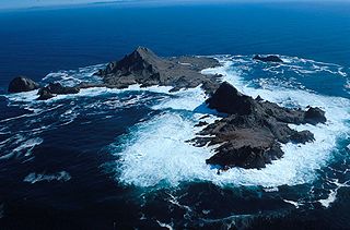
<span class="mw-page-title-main">Farallon Islands</span> Group of islands off the coast of California, United States

The Farallon Islands, or Farallones, are a group of islands and sea stacks in the Gulf of the Farallones, off the coast of San Francisco, California, United States. The islands are also sometimes referred to by mariners as the Devil's Teeth Islands, in reference to the many treacherous underwater shoals in their vicinity. The islands lie 30 miles (48 km) outside the Golden Gate and 20 miles (32 km) south of Point Reyes, and are visible from the mainland on clear days. The islands are part of the City and County of San Francisco. The only inhabited portion of the islands is on Southeast Farallon Island (SEFI), where researchers from Point Blue Conservation Science and the U.S. Fish and Wildlife Service stay. The islands are closed to the public.

<span class="mw-page-title-main">Greater Farallones National Marine Sanctuary</span> Marine protected area in California, USA

The Greater Farallones National Marine Sanctuary protects the wildlife, habitats, and cultural resources of one of the most diverse and bountiful marine environments in the world, an area of 3,295 square miles off the northern and central California coast. The waters within Greater Farallones National Marine Sanctuary are part of a nationally significant marine ecosystem, and support an abundance of life, including many threatened or endangered species.
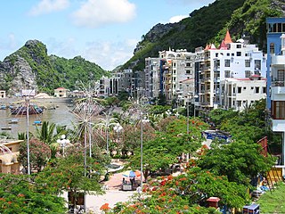
<span class="mw-page-title-main">Monterey Bay National Marine Sanctuary</span> Marine protected area in California, U.S.

The Monterey Bay National Marine Sanctuary (MBNMS) is a federally protected marine area offshore of California's Big Sur and central coast in the United States. It is the largest US national marine sanctuary and has a shoreline length of 276 miles (444 km) stretching from just north of the Golden Gate Bridge at San Francisco to Cambria in San Luis Obispo County. Supporting one of the world's most diverse marine ecosystems, it is home to numerous mammals, seabirds, fishes, invertebrates and plants in a remarkably productive coastal environment. The MBNMS was established in 1992 for the purpose of resource protection, research, education, and public use.

<span class="mw-page-title-main">Golden Gate National Recreation Area</span> U.S. National Recreation Area surrounding San Francisco Bay Area

The Golden Gate National Recreation Area (GGNRA) is a U.S. National Recreation Area protecting 82,116 acres (33,231 ha) of ecologically and historically significant landscapes surrounding the San Francisco Bay Area. Much of the park is land formerly used by the United States Army. GGNRA is managed by the National Park Service and is the second-most visited unit of the National Park system in the United States, with more than 15.6 million visitors in 2022. It is also one of the largest urban parks in the world, with a size two-and-a-half times that of the consolidated city and county of San Francisco.
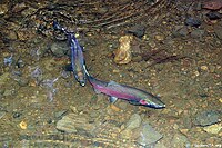
<span class="mw-page-title-main">California Coast Ranges</span> Mountain range

The Coast Ranges of California span 400 miles (644 km) from Del Norte or Humboldt County, California, south to Santa Barbara County. The other three coastal California mountain ranges are the Transverse Ranges, Peninsular Ranges and the Klamath Mountains.

<span class="mw-page-title-main">Butrint National Park</span> National park and a tourist attraction in southwestern Albania

Butrint National Park is a national park in Vlorë County, southern Albania. It is located 18 kilometres (11 mi) south of Sarandë. The park encompasses 9,424 hectares (94.24 km2) of hilly terrain with freshwater lakes, wetlands, salt marshes, open plains, reed beds and islands. The park's significance for conservation is reflected in the large number of species with over 1,200 different animals and plants. Its mandate includes the protection of the lake and lagoon of Butrint, the natural channel of Vivari, the islands of Ksamil and as well the archaeological site, that provides valuable remains of ancient civilisations.

<span class="mw-page-title-main">Red Triangle (Pacific Ocean)</span>

The Red Triangle is the colloquial name of a roughly triangle-shaped region off the coast of northern California, extending from Bodega Bay, north of San Francisco, out slightly beyond the Farallon Islands, and down to the Big Sur region, south of Monterey. The area has a very large population of marine mammals, such as elephant seals, harbor seals, sea otters and sea lions, which are favored prey of great white sharks. Around thirty-eight percent of recorded great white shark attacks on humans in the United States have occurred within the Red Triangle—eleven percent of the worldwide total. The area encompasses the beaches of the heavily populated San Francisco Bay Area, and many people enjoy surfing, windsurfing, swimming and diving in these waters.

<span class="mw-page-title-main">Gulf of the Farallones</span> Gulf between the Farallon Islands and the mainland coast of California, United States

Gulf of the Farallones is a gulf of the Pacific Ocean off the northern California coast. It extends westward from the opening of the San Francisco Bay and Drakes Bay to the Farallon Islands. Most of the gulf lies in Gulf of the Farallones National Marine Sanctuary, which protects about 1,250 square miles (3,200 km2).

<span class="mw-page-title-main">Cuchillas del Toa</span> Biosphere reserve in Cuba

Cuchillas del Toa is a Biosphere Reserve in Cuba. It is located in the eastern part of the country, mostly in the Guantánamo Province and reaching to the north into the Holguín Province. Most of the reserve is established in the drainage area of the Toa River, which flows for 118 km (73 mi) to the Atlantic Ocean in Baracoa.

<span class="mw-page-title-main">Redwood Creek Native Plant Nursery</span>

Redwood Creek Native Plant Nursery was located just outside the old-growth redwood forest at Muir Woods National Monument. The nursery provided plants for restoration of the creek bank in the lower watershed and impacted areas of the Muir Woods' redwood understory. It was moved to that location in 1992, and closed in 2015.

<span class="mw-page-title-main">Phillip Burton Wilderness</span> Protected wilderness area in California, United States

The Phillip Burton Wilderness is part of the 111 sq. mile (288 km2) Point Reyes National Seashore located about 20 miles (32 km) northeast of San Francisco, California. Total wilderness land is 33,373 acres which includes a roadless "potential wilderness" area of over 8,000 acres (32 km2) and is one of only three designated wilderness along the California coast, the others being the King Range Wilderness and the Rocks and Islands Wilderness. The National Park Service manages the wilderness.

Biosphere reserves are established according to the UNESCO's Man and the Biosphere Programme (MAB) to promote sustainable development for conservation of biological and cultural diversity. As of 2016, the Lal Suhanra Biosphere Reserve and Ziarat Juniper Forest are the only two biosphere reserve in Pakistan, which were approved by UNESCO in 1977 and 2013 respectively. A number of initiatives and projects have been undertaken to promote and develop other biosphere reserves in Pakistan but due to weak implementation this has not yet been materialized. In July 2012, Pakistan Museum of Natural History and Beijing Museum of Natural History signed a MoU to work on trans-boundary biodiversity and to improve MAB related activities in the Karakoram, Himalaya, and Hindukush regions.

<span class="mw-page-title-main">California Coast Ranges Biosphere Reserve</span>

The California Coast Ranges Biosphere Reserve was a UNESCO Biosphere reserve located along the California Coast Ranges of northern California and the San Francisco Bay area until June 2017. This biosphere reserve includes a highly diverse complex of evergreen sclerophyllous woodland, coastal, estuary and marine ecosystems.

<span class="mw-page-title-main">Clayoquot Sound Biosphere Reserve</span> UNESCO Biosphere Reserve in British Columbia, Canada

Clayoquot Sound Biosphere Reserve is a UNESCO Biosphere Reserve situated in Clayoquot Sound on the west coast of Vancouver Island in British Columbia, Canada. A diverse range of ecosystems exist within the biosphere reserve boundaries, including temperate coastal rainforest, ocean and rocky coastal shores.

<span class="mw-page-title-main">Albanian Ionian Sea Coast</span> Albanian coastline of the north-eastern Ionian Sea

The Albanian Ionian Sea Coast is a coastline of the north-eastern Ionian Sea, that encompasses the south-western border of the Republic of Albania, stretching from the southern half of Karaburun Peninsula, across the historical region of Labëria, the city of Sarandë, the mountains of the Ceraunians, and the Albanian Riviera, to the Lake of Butrint, where the Strait of Corfu separates the country from Greece.

References

  1. 1 2 3 4 5 6 7 8 9 10 “Golden Gate Biosphere Periodic Review.” 2016. UNESCO Man and the Biosphere Programme.
  2. "What Makes GGNRA Special". National Park Service. Retrieved July 20, 2021.
  3. UNESCO (2020). "Statutory framework of the World Network of Biosphere Reserves". UNESDOC.
  4. “Golden Gate Biosphere Periodic Review.” 2016. UNESCO Man and the Biosphere Programme.
  5. "Man and the Biosphere (MAB) Programme". UNESCO.
  6. "Fulfilling the Three Functions". UNESCO.
  7. 1 2 3 “Greater Farallones National Marine Sanctuary Advisory Council Meeting.” 2017. UNESCO Man and the Biosphere Programme. https://nmsfarallones.blob.core.windows.net/farallones-prod/media/archive/manage/pdf/sac/17_05/ggbr_presentation.pdf.
  8. "Golden Gate Biosphere". Greater Farallones National Marine Sanctuary. Retrieved July 20, 2021.
  9. 1 2 “San Francisco Bay Area and Delta Protection.” n.d. Center for Biological Diversity. Accessed August 13, 2021. https://www.biologicaldiversity.org/campaigns/san_francisco_bay_area_and_delta_protection/.
  10. “Foundation Statement; Golden Gate National Recreation Area, Muir Woods National Monument, Fort Point National Historic Site.” 2006. National Park Service. https://www.nps.gov/goga/learn/management/upload/061128-foundation-final.pdf.
  11. "Hands Abound to Help Coho Salmon - Golden Gate National Recreation Area (U.S. National Park Service)". www.nps.gov. Retrieved 2021-08-12.