Ocean Beach, San Francisco

Last updated

Cliff House from Ocean Beach Cliff House from Ocean Beach.jpg
Cliff House from Ocean Beach
Aerial view of the Ocean Beach neighborhood at Taraval Street Ocean Beach San Francisco aerial view.jpg
Aerial view of the Ocean Beach neighborhood at Taraval Street

Ocean Beach is a beach on the west coast of San Francisco, California, United States, bordering the Pacific Ocean. It is adjacent to Golden Gate Park, the Richmond District, and the Sunset District. The Great Highway runs alongside the beach, and the Cliff House and the site of the former Sutro Baths sit at the northern end. The beach is a part of the Golden Gate National Recreation Area, which is administered by the National Park Service. It is accessible via Muni Metro at the Judah and La Playa station.

Contents

During the late spring and summer, San Francisco's characteristic foggy weather frequently envelops the beach. The average temperature for the last 5 years has been 13.2 °C (55.8 °F) [1] Most of the beach-friendly weather occurs in the fall (usually mid to late September) and early in the spring when fog and strong sea breezes are less prevalent. Dry winter days also tend to provide excellent weather at Ocean Beach (especially in drought years).

The water at Ocean Beach is noteworthy for its strong, dangerous currents and powerful waves, which make it popular among serious surfers. The water is cold, due in part to a process known as upwelling, in which frigid water from below the ocean surface rises to replace the surface water that moves away from the beach as a result of the Coriolis effect. The rapid rip currents, cold water, and threat of sneaker waves [2] make the ocean dangerous for casual swimmers and even those who simply want to set foot in it, especially those without wetsuits and lifejackets, because swimmers and even waders [3] have been swept away and drowned. The southern portion of the beach by Sloat Boulevard has some of the cleanest water in the state. [4]

Surfing

The beach is one of the Bay Area's top surfing spots and — when breaking well — can be world class, especially during large swells in the winter months. Surfers and other swimmers have died at Ocean Beach; one example occurred in May 2006, [5] with the next-previous death taking place in January 2006. [6] Prior to that, it had been about five years since a death at Ocean Beach. In 1998, a record seven people lost their lives there. [7]

The Ocean Beach surfing community is served by four surf shops and several popular beach-themed cafes. Seal Rock is a prominent local feature of the area. Third Eye Blind's Motorcycle Drive By was written about this beach.

On November 6, 2011, Ocean Beach hosted the Rip Curl Pro surfing competition, in which Kelly Slater won his 11th ASP world championship at the age of 39. This was the only one of his championships won in the continental United States. [8]

History

Sutro Baths in 1896 Sutro Baths in San Francisco.jpg
Sutro Baths in 1896

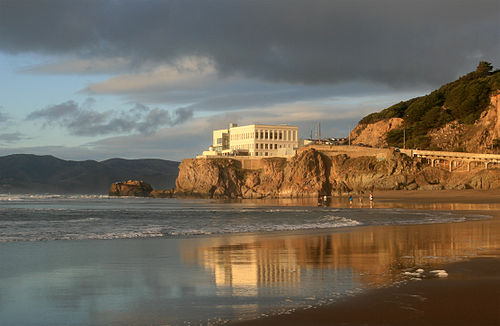
Due in part to its sometimes inhospitable weather (high winds, cold weather and fog), the area was largely undeveloped throughout most of San Francisco's early history, when it was known as part of the "Outside Lands." Development finally came in the late 19th century: a steam railroad was in place by 1884 to bring people to the first amusement ride at the city's oceanside, a "Gravity Railroad" roller coaster, and to the Ocean Beach Pavilion for concerts and dancing. By 1890, trolley lines reached Ocean Beach: the Ferries and Cliff House Railroad, Park & Ocean Railroad, and Sutro Railroad that encouraged commercial amusement development as a trolley park. [9] The Cliff House, which opened in 1863, and Sutro Baths, which opened in 1896, drew thousands of visitors. [10]

Railroads

The Park and Ocean Railroad ran along Lincoln Way on the south edge of Golden Gate Park and then turned north into the western end of the Park along La Playa Street. This standard-gauge railway began service on December 1, 1883, using four locomotives built by Baldwin Locomotive Works in November 1880 for the Central Pacific Railroad but lettered Market Street, Park & Cliff Railroad. These four 0-4-2 T (tank locomotives) (C/N 5357, 5357, 5375 & 5377) were joined by four 2-4-2 T Baldwins (C/N 7201, 7203, 7238 & 7243) built in March 1884. When the line was electrified in 1900, Locomotive #1 went to the Mendocino Lumber Company, three of the 2-4-2 T s went to Canadian Collieries, and the remaining four became Southern Pacific Transportation Company numbers 20, 21, 22 and 80. Number 20 was preserved at Travel Town Museum in 1954. [11]

The Park and Cliff House Railroad ran west along California Street and then along the coast to turn south on 48th Avenue. This 36-inch (91 cm) narrow-gauge railway began service in 1887 with six 2-4-2 T Baldwins (C/N 8955, 8961, 8973, 8974, 9065 & 9073). The company was reorganized as the Ferries and Cliff House Railroad with two more 2-4-2 T Baldwins (C/N 9756 & 9763) built in 1889. These locomotives were widely distributed during the first decade of the 20th century. One went to the Diamond and Caldor Railway, one to the Oahu Railway and Land Company, one to the San Jose and Santa Clara Electric Company, one to the Glynn and Peterson Lumber Company, and two to the Red River Lumber Company in Westwood, California. [11]

Resort era

Playland, San Francisco in 1918 Playland San Francisco 1918 a.jpg
Playland, San Francisco in 1918

Following a brief stint as a refugee camp after the 1906 earthquake, the area was touted as a resort. A small amusement park, Playland at the Beach, was built where Cabrillo and Balboa streets now end. Major development occurred in the 1920s and 1930s with construction of the Great Highway and housing in the adjacent Sunset and Richmond Districts. After the destruction of the Sutro Baths in 1966, the neighborhood lost its resort appeal; the amusement park was also torn down in 1972, to be replaced by apartment blocks and a supermarket in the 1990s.

The shipwreck of the King Philip in May 2007 Shipwreck at Ocean Beach.jpg
The shipwreck of the King Philip in May 2007

On January 25, 1878, the King Philip, a three-masted clipper ship, drifted onto Ocean Beach and foundered. From time to time, the wreckage of the ship still emerges from the sands just offshore, most recently reappearing in November 2010. [12]

San Francisco Ocean Beach 01.jpg
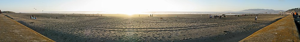
San Francisco Ocean Beach at sunset, October 2007. Photo from northern end of beach.

See also

Related Research Articles

<span class="mw-page-title-main">Richmond District, San Francisco</span> Neighborhood in San Francisco, California, United States

The Richmond District is a neighborhood in the northwest corner of San Francisco, California, developed initially in the late 19th century. It is sometimes confused with the city of Richmond, which is 20 miles (32 km) northeast of San Francisco.

<span class="mw-page-title-main">Sunset District, San Francisco</span> Neighborhood in San Francisco, California, United States

The Sunset District is a neighborhood located in the southwest quadrant of San Francisco, California, United States.

<span class="mw-page-title-main">Trolley park</span> Amusement park prototype

In the United States, trolley parks, which started in the 19th century, were picnic and recreation areas along or at the ends of streetcar lines in most of the larger cities. These were precursors to amusement parks. Trolley parks were often created by the streetcar companies to give people a reason to use their services on weekends.

<span class="mw-page-title-main">Adolph Sutro</span> American politician

Adolph Heinrich Joseph Sutro was a German-American engineer, politician and philanthropist who served as the 24th mayor of San Francisco from 1895 until 1897. Born a German Jew, he moved to Virginia City, Nevada and made a fortune at the Comstock Lode. Several places in San Francisco bear his name in remembrance of his life and contributions to the city.

<span class="mw-page-title-main">Sutro Baths</span> Large defunct saltwater swimming pool complex in San Francisco, now ruins.

<span class="mw-page-title-main">Ocean Beach, San Diego</span> Community of San Diego in California, United States

Ocean Beach is a beachfront neighborhood of San Diego, California.

<span class="mw-page-title-main">Santa Cruz Beach Boardwalk</span> Amusement park in Santa Cruz, California

The Santa Cruz Beach Boardwalk is an oceanfront amusement park in Santa Cruz, California. Founded in 1907, it is California's oldest surviving amusement park and one of the few seaside parks on the West Coast of the United States.

<span class="mw-page-title-main">Geary Boulevard</span> Thoroughfare in San Francisco, United States

Geary Boulevard is a major east–west 5.8-mile-long (9 km) thoroughfare in San Francisco, California, United States, beginning downtown at Market Street near Market Street's intersection with Kearny Street, and running westbound through downtown, the Civic Center area, the Western Addition, and running for most of its length through the predominantly residential Richmond District. Geary Boulevard terminates near Sutro Heights Park at 48th Avenue, close to the Cliff House above Ocean Beach at the Pacific Ocean. At 42nd Avenue, Geary intersects with Point Lobos Avenue, which takes through traffic to the Cliff House, Ocean Beach and the Great Highway. It is a major commercial artery through the Richmond District; it is lined with stores and restaurants, many of them catering to the various immigrant groups who live in the area. The boulevard borders Japantown between Fillmore and Laguna Streets.

<span class="mw-page-title-main">Torrey Pines State Beach</span> State park in California, United States

Torrey Pines State Beach is a public beach located in the San Diego, California community of Torrey Pines, south of Del Mar and north of La Jolla. Coastal erosion from the adjacent Torrey Pines State Reserve makes for a picturesque landscape. It is a local favorite among surfers and remains a quintessential Southern California beach. Occurrences of bioluminescence in the waters near the beach have been noted.

<span class="mw-page-title-main">Half Moon Bay State Beach</span> Group of beaches in San Mateo County, California

Half Moon Bay State Beach is a 4-mile (6 km) stretch of protected beaches in the state park system of California, United States, on Half Moon Bay. From north to south it comprises Roosevelt, Dunes, Venice, and Francis Beaches. The 181-acre (73 ha) park was established in 1956.

<span class="mw-page-title-main">Cliff House, San Francisco</span> Landmark building (built 1863)

The Cliff House is a neo-classical style building perched on the headland above the cliffs just north of Ocean Beach, in the Outer Richmond neighborhood of San Francisco, California. The building overlooks the site of the Sutro Baths ruins, Seal Rocks, and is part of the Golden Gate National Recreation Area, operated by the National Park Service (NPS). The Cliff House is owned by the NPS; the building's terrace hosts a room-sized camera obscura.

<span class="mw-page-title-main">Seal Rocks (San Francisco, California)</span> Rock islands in Pacific Ocean in western San Francisco, California

Seal Rock is a group of small rock formation islands in the Lands End area of the Outer Richmond District in western San Francisco, California. They are located just offshore in the Pacific Ocean, at the north end of the Ocean Beach, near the Cliff House and Sutro Baths ruins.

<span class="mw-page-title-main">Golden Gate National Recreation Area</span> U.S. National Recreation Area surrounding San Francisco Bay Area

The Golden Gate National Recreation Area (GGNRA) is a U.S. National Recreation Area protecting 82,116 acres (33,231 ha) of ecologically and historically significant landscapes surrounding the San Francisco Bay Area. Much of the park is land formerly used by the United States Army. GGNRA is managed by the National Park Service and is the second-most visited unit of the National Park system in the United States, with more than 15.6 million visitors in 2022. It is also one of the largest urban parks in the world, with a size two-and-a-half times that of the consolidated city and county of San Francisco.

<span class="mw-page-title-main">Sutro Heights Park</span>

Sutro Heights Park is an historic public park in the Outer Richmond District of western San Francisco, California. It is within the Golden Gate National Recreation Area and the Sutro Historic District.

<span class="mw-page-title-main">Playland (San Francisco)</span> Amusement park in California, 1921 to 1972

Playland was a 10-acre (40,000-square-meter) seaside amusement park located next to Ocean Beach, in the Richmond District at the western edge of San Francisco, California, along Great Highway, bounded by Balboa and Fulton streets. It began as a collection of amusement rides and concessions in the late 19th century, and was preceded by Chutes at the Beach, opened in 1921. Playland closed Labor Day weekend in 1972.

Playland-Not-At-The-Beach was a non-profit, family-oriented museum in El Cerrito, California celebrating America's bygone amusements, operated entirely by volunteers.

<span class="mw-page-title-main">Sutro District</span> National Park Service historic district in western San Francisco within the GGNRA

The Sutro Historic District is a National Park Service historic district in the Lands End area of the Outer Richmond District in western San Francisco, California. It is within the Golden Gate National Recreation Area, since being acquired by the National Park Service in 1977.

<span class="mw-page-title-main">Lands End (San Francisco)</span> Park within the Golden Gate National Recreation

Lands End is a park in San Francisco within the Golden Gate National Recreation Area. It is a rocky and windswept shoreline at the mouth of the Golden Gate, situated between the Sutro District and Lincoln Park and abutting Fort Miley Military Reservation. A memorial to USS San Francisco stands in the park. Numerous hiking trails follow the former railbeds of the Ferries and Cliff House Railway along the cliffs and also down to the shore.

<span class="mw-page-title-main">Pleasure Point, California</span> Census-designated place in California, United States

Pleasure Point is a census-designated place (CDP) in Santa Cruz County, California. Pleasure Point sits at an elevation of 33 feet (10 m). The 2020 United States census reported Pleasure Point's population was 5,821. Prior to the 2010 census, this CDP was called Opal Cliffs.

References

  1. "Ocean Beach GGNRA Weather | Personal Weather Station: KCASANFR107 by Wunderground.com | Weather Underground". www.wunderground.com. Retrieved September 17, 2015.
  2. Ted Andersen (September 28, 2018). "California's deadliest beach is in the Bay Area". SFGATE. Retrieved August 10, 2020.
  3. "Two Teen Boys, In A Group Of Five Friends, Swept Out To Sea At Ocean Beach, Presumed Dead" . Retrieved April 24, 2022.
  4. Carolyn Jones (May 27, 2010). "Bay Area beaches grade well for safe swimming". San Francisco Chronicle. Retrieved September 8, 2012.
  5. Davidson, Keay; Rubenstein, Steve (May 16, 2006). "Ocean Beach rip currents lethal". San Francisco Chronicle. Retrieved November 27, 2010.
  6. Sturrock, Carrie (January 23, 2006). "Surfer dies off Ocean Beach". San Francisco Chronicle. Retrieved November 27, 2010.
  7. Herel, Suzanne; Finz, Stacy (January 24, 2006). "Taste of surfing proves fatal". San Francisco Chronicle. Retrieved November 27, 2010.
  8. Almond, Elliott (November 2, 2011). "Kelly Slater wins title No. 11 at Ocean Beach". The Mercury News. Retrieved April 24, 2022.
  9. Amusing America, San Francisco Public Library online exhibit, Sept 2006. Accessed 7 August 2007.
  10. Beldner, Ray Public Art: Playland Revisited Archived 2007-08-17 at the Wayback Machine . Access 7 August 2007.
  11. 1 2 Borden, Stanley T. (1971). "San Francisco Steam Dummies". The Western Railroader. Francis A. Guido. 34 (376): 9.
  12. Mark Lukach. "The Return of the King Philip Shipwreck". oceanbeachbulletin.com. Archived from the original on July 30, 2013. Retrieved July 19, 2013.

37°45′34″N122°30′39″W / 37.75944°N 122.51083°W / 37.75944; -122.51083