
Corte Madera is an incorporated town in Marin County, California. Corte Madera is located 3.25 miles (5.2 km) south of San Rafael, at an elevation of 39 feet. The population was 10,222 at the 2020 census. The town was named after the Spanish imperative command "chop wood", as the area was famous for producing redwood tree lumber which was used in the construction of the city of San Francisco.

Larkspur is a city in Marin County, California, United States. Larkspur is located 3 miles (4.8 km) south of San Rafael, at an elevation of 43 feet (13 m). As of the 2020 Census, the city's population was 13,064. Larkspur's Police Department is shared with that of the neighboring Corte Madera and town of San Anselmo as the Central Marin Police Authority. Intersecting Larkspur's downtown is Madrone Canyon, a residential area amidst a redwood grove.

Mill Valley is a city in Marin County, California, United States, located about 14 miles (23 km) north of San Francisco via the Golden Gate Bridge and 52 miles (84 km) from Napa Valley. The population was 14,231 at the 2020 census.

The North Bay is a subregion of the San Francisco Bay Area, in California, United States. The largest city is Santa Rosa, which is the fifth-largest city in the Bay Area. It is the location of the Napa and Sonoma wine regions, and is the least populous and least urbanized part of the Bay Area. It consists of Marin, Napa, Solano and Sonoma counties.
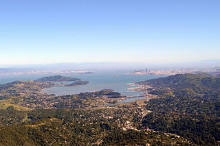
Richardson Bay is a shallow, ecologically rich arm of San Francisco Bay, managed under a Joint Powers Agency of four northern California cities. The 911-acre (369 ha) Richardson Bay Sanctuary was acquired in the early 1960s by the National Audubon Society. The bay was named for William A. Richardson, early 19th century sea captain and builder in San Francisco. It contains both Strawberry Spit and Aramburu Island.
Greenbrae is a small unincorporated community in Marin County, California. It is located 1.5 miles (2 km) south-southeast of downtown San Rafael, at an elevation of 33 feet, located adjacent to U.S. Route 101 at the opening of the Ross Valley. Part of Greenbrae is an unincorporated community of the county while the remaining area is inside the city limits of Larkspur. The ZIP code is 94904, and is shared with the neighboring Census-designated place (CDP) of Kentfield. The community is in area codes 415 and 628.

The Tamalpais Union High School District or TUHSD provides high school education to students residing in ten elementary districts in central and southern Marin County, California and parts of West Marin. The headquarters are on the property of Redwood High School in Larkspur, California.

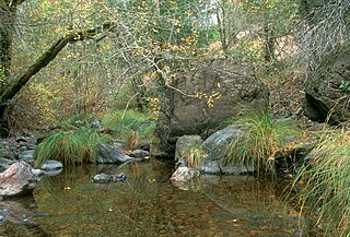
Arroyo Corte Madera del Presidio is a 4.1-mile-long (6.6 km) year-round stream in southern Marin County, California, United States. This watercourse is also known as Corte Madera Creek, although the actual stream of that name flows into San Francisco Bay further north at Point San Quentin. This watercourse has a catchment basin of about 8 square miles (21 km2) and drains the south-eastern slopes of Mount Tamalpais and much of the area in and around the town of Mill Valley; this stream discharges to Richardson Bay.
Rancho Corte Madera del Presidio was a 7,845-acre (31.75 km2) Mexican land grant in present day Marin County, California given in 1834 by Governor José Figueroa to John (Juan) Reed. Corte Madera del Presidio means the "lumber mill of the Presidio". The grant encompassed what is now southern Corte Madera, Mill Valley, the Tiburon Peninsula, and Strawberry Point. It reached from Point Tiburon to Larkspur Creek, then known as Arroyo Holon.
Rancho Saucelito was a 19,752-acre (79.93 km2) Mexican land grant in present-day Marin County, California, given in 1838 by Governor Juan Alvarado to William A. Richardson. The name means "ranch of the little willow grove". The grant extended from the Pacific Ocean on the west, to Mount Tamalpais to the north, and the Arroyo Corte Madera del Presidio and Richardson Bay on the east; and included present-day Muir Beach, Stinson Beach, Sausalito, Tamalpais Valley, and Homestead Valley.

Coyote Creek is a stream in the Richardson Bay watershed, draining Tamalpais-Homestead Valley, California eastward into Richardson Bay, Marin County, California, United States. The stream originates on Coyote Ridge and flows 2.5 miles (4.0 km) to the bay at the south end of Bothin Marsh.

Corte Madera Creek is a short stream which flows southeast for 4.5 miles (7.2 km) in Marin County, California. Corte Madera Creek is formed by the confluence of San Anselmo Creek and Ross Creek in Ross and entering a tidal marsh at Kentfield before connecting to San Francisco Bay near Corte Madera.
San Anselmo Creek is an eastward-flowing stream that begins on the eastern flank of Pine Mountain in the Marin Hills of Marin County, California. At its confluence with Ross Creek, it becomes Corte Madera Creek.

Larkspur Creek is a short stream which flows 3.5 miles east to meet Corte Madera Creek in Larkspur, California just before reaching Richardson's Bay. The creek was named for the town of Larkspur, which was named by Georgiana Wright, a Briton and spouse of the 1887 developer of the area. She named the town of Larkspur for lupine flowers on the hills that she mistook for larkspur.

The Northwestern Pacific Railroad operated a network of electric interurban lines in Marin County, California from 1903 to 1941. The lines ran to Sausalito at the southern tip of the county, where connecting ferries ran to San Francisco. Trains consisted of electric multiple units powered by third rail electrification. The lines were the first third-rail electrification in California, and the first major railroad to use alternating current signals.
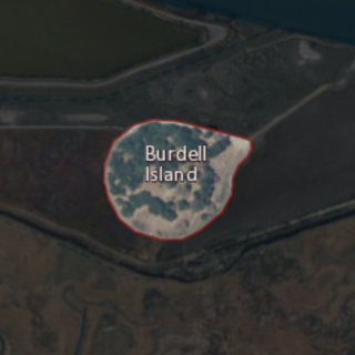
Burdell Island is a former island in the Petaluma River, upstream of San Pablo Bay. While it was previously surrounded by water and swampland, it is now surrounded mostly by dry land. It is part of Marin County, California. Its coordinates are 38°09′22″N122°33′17″W, and the United States Geological Survey gave its elevation as 52 ft (16 m) in 1981. It appears in a 1954 USGS map of the region.

Day Island is an island at the mouth of the Petaluma River in San Pablo Bay. It is part of Marin County, California. Its coordinates are 38°06′13″N122°29′26″W, and the United States Geological Survey measured its elevation as 105 ft (32 m) in 1981. It appears on a 1951 USGS map of the area, although it appears on maps from as old as 1873. The "1880 History of Marin County" by Alley, Bowen and Co. mentions "a man by name of Day" who "settled on an island in Novato township which has since borne his name" in 1851." To this day, there are still 2 houses on the island, both inhabited. The island is bordered by dirt and two lagoons to the west, and marshlands to the east, although it was once entirely surrounded by either marshland or water.

Wood Island is a former island in Marin County, California, formerly in the Corte Madera Creek but now surrounded by land. Its coordinates are 37°56′37″N122°30′42″W, and the United States Geological Survey measured its elevation as 13 ft (4.0 m) in 1981. It appears in a 1954 USGS map of the region. In the 1960s, its principal owner was Spero Spiliotis. In 1969, the city of Larkspur passed a resolution of intent to annex the island, and in the 1970s, a ferry terminal had been proposed.

Simms Island is a former marsh island in San Francisco Bay. It is in Marin County, California; Its coordinates are 37°57′33″N122°30′18″W, and the United States Geological Survey (USGS) gave its elevation as 13 ft (4.0 m) in 1981. It appears as an island on a USGS map in 1897; it is labeled in a 1954 map, but fully connected to the mainland.

Old Mill Creek is a 2.3-mile-long (3.7 km) year-round stream in southern Marin County, California, United States. Old Mill Creek is a tributary to Arroyo Corte Madera del Presidio, which, in turn, flows to Richardson Bay at Mill Valley's municipal Bayfront Park and 106 acres (0.43 km2) Bothin Marsh.


