Wine Country is the region of California, in the northern Bay Area, known worldwide as a premier wine-growing region. The region is famed for its wineries, its cuisine, Michelin star restaurants, boutique hotels, luxury resorts, historic architecture, and culture. Viticulture and wine-making have been practiced in the region since the Spanish missionaries from Mission San Francisco Solano established the first vineyards in 1812.

San Pablo Bay is a tidal estuary that forms the northern extension of San Francisco Bay in the East Bay and North Bay regions of the San Francisco Bay Area in northern California.

The Napa River is a river approximately 55 miles (89 km) long in the U.S. state of California. It drains a famous wine-growing region called the Napa Valley, in the mountains north of the San Francisco Bay. Milliken Creek and Mt. Veeder watersheds are a few of its many tributaries. The river mouth is at Vallejo, where the intertidal zone of fresh and salt waters flow into the Carquinez Strait and the San Pablo Bay.

Sonoma Valley is a valley located in southeastern Sonoma County, California, in the North Bay region of the San Francisco Bay Area. Known as the birthplace of the California wine industry, the valley is home to some of the earliest vineyards and wineries in the state, some of which survived the phylloxera epidemic of the 1870s and the impact of prohibition in the early 20th century. Today, the valley's wines are protected by the U.S. Federal Government's Sonoma Valley and Carneros AVAs.

Located in northern California, the Suisun Marsh has been referred to as the largest brackish water marsh on west coast of the United States of America. The marsh land is part of the San Francisco Bay tidal estuary, and subject to tidal ebb and flood. The marsh is home to many species of birds and other wildlife, and is formed by the confluence of the Sacramento and San Joaquin rivers between Martinez and Suisun City, California and several other smaller, local watersheds. Adjacent to Suisun Bay, the marsh is immediately west of the legally defined Sacramento-San Joaquin Delta as well as part of the San Francisco Bay estuary.

Sonoma Creek is a 33.4-mile-long (53.8 km) stream in northern California. It is one of two principal drainages of southern Sonoma County, California, with headwaters rising in the rugged hills of Sugarloaf Ridge State Park and discharging to San Pablo Bay, the northern arm of San Francisco Bay. The watershed drained by Sonoma Creek is roughly equivalent to the wine region of Sonoma Valley, an area of about 170 square miles (440 km2). The State of California has designated the Sonoma Creek watershed as a “Critical Coastal Water Resource”. To the east of this generally rectangular watershed is the Napa River watershed, and to the west are the Petaluma River and Tolay Creek watersheds.
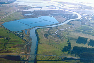
The Napa Sonoma Marsh is a wetland at the northern edge of San Pablo Bay, which is a northern arm of the San Francisco Bay in California, United States. This marsh has an area of 48,000 acres (194 km2), of which 13,000 acres (53 km2) are abandoned salt evaporation ponds. The United States Government has designated 13,000 acres (53 km2) in the Napa Sonoma Marsh as the San Pablo Bay National Wildlife Refuge.
Cordelia Slough is a 10.8-mile-long (17.4 km) tidal watercourse which discharges to the Suisun Slough, which in turn empties into Grizzly Bay in Solano County, California. The Suisun Slough, fed by the Green Valley Creek and Red Top Creek, provides a productive habitat for a diversity of aquatic flora and fauna. In particular steelhead migrate up Cordelia Slough to spawn in its two tributaries.
Tolay Creek is a 12.5-mile-long (20.1 km) southward-flowing stream in southern Sonoma County, California, United States, which flows through Tolay Lake and ends in north San Pablo Bay.

The Howell Mountains, which are also known as the Mt. George Range, are one of the California Coast Ranges. They divide the Suisun Valley on the east side, from Napa Valley on the west. Historically the southern part of the range has been referred to as both the Sierra de Suscol and as the Sierra de Napa.

Joice Island is a small island in Grizzly Bay in California. It is part of Suisun Marsh, and has been used for hunting since the late 19th century. After a failed attempt to reclaim the land for asparagus and alfalfa farming in the early 1900s, Joice Island spent several decades as a wildlife refuge before being opened to the public for hunting in 1964. Currently, the upper portion of Joice Island is part of the California Department of Fish and Wildlife's Grizzly Island Wildlife Area; fishing, as well as the hunting of waterfowl and pigs, is permitted there on a limited basis.

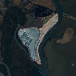
Bull Island is an island in the Napa River, in Napa County, California. From the 1880s onward, it was owned by the Money family, who constructed levees and reclaimed the land, using it to farm grain and potatoes. It was described as a "fine ranch" in 1918. After a levee failure in 1954, it gradually eroded into the water, becoming a salt marsh; for some time afterward, it was used as an evaporation pond for the industrial production of salt by the Leslie Salt Company. Beginning in the 1970s, Bull Island was proposed for inclusion in a variety of riparian preservation projects, but none came to fruition. However, in 1997, the Money family sold it to the California State Lands Commission, who turned it into a wildlife habitat; today it is administered as part of the Fagan Marsh Ecological Reserve, and hosts animals of numerous endangered species.

Coon Island is an island in the Napa River, upstream of San Pablo Bay. It is in Napa County, California, and managed as part of the Napa-Sonoma Marshes Wildlife Area. Its coordinates are 38°11′33″N122°19′24″W, and the United States Geological Survey measured its elevation as 3 ft (0.91 m) in 1981.
Edgerly Island is an island in the Napa River, upstream of San Pablo Bay. It is in Napa County, California, and managed as part of the Napa-Sonoma Marshes Wildlife Area. Its coordinates are 38°12′12″N122°18′52″W, and the United States Geological Survey measured its elevation as 3 ft (0.91 m) in 1981.

Green Island is an island in the Napa River, upstream of San Pablo Bay. It is in Napa County, California, and managed as part of the Napa-Sonoma Marshes Wildlife Area. Its coordinates are 38°12′09″N122°18′16″W, and the United States Geological Survey measured its elevation as 23 ft (7.0 m) in 1981. It, long with Island No. 1, Island No. 2 and Tubbs Island, are labeled on a 1902 USGS map of the area.
Island No. 1 is a partially submerged island in the Napa River, upstream of San Pablo Bay. It is in Napa and Solano County, California, and parts of it are managed as part of the Napa-Sonoma Marshes Wildlife Area. Its coordinates are 38°08′35″N122°20′40″W, and the United States Geological Survey measured its elevation as 3 ft (0.91 m) in 1981. It, along with Island No. 2, Green Island and Tubbs Island, are labeled on a 1902 USGS map of the area.

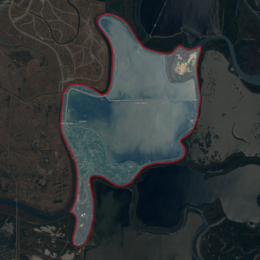
Island No. 2 is a mostly-submerged island in Solano County, California. Formerly swampland, it was reclaimed into productive farmland, and became the subject of lengthy legal disputes in the early 20th century. Since then, it has become again submerged, and is now part of the Napa-Sonoma Marshes Wildlife Area.

Knight Island is a mostly-submerged island in the Napa River, upstream of San Pablo Bay. It is in Solano County, California, and managed as part of the Napa-Sonoma Marshes Wildlife Area. Its coordinates are 38°08′09″N122°17′58″W, and the United States Geological Survey measured its elevation as 3 ft (0.91 m) in 1981.

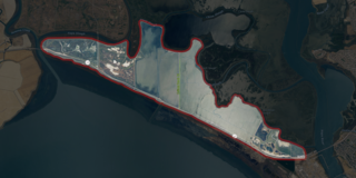
Russ Island is a mostly-submerged island in the Napa River, in Napa and Solano Counties, California. It was reclaimed in the late 19th century, and spent many years as productive farmland; in the 1950s, however, it was purchased by the Leslie Salt Company, and deliberately submerged to serve as an evaporation pond for salt production. The company allowed parts of it to be used for duck hunting. By the 1990s, it was acquired by the California Department of Fish and Game, who turned it into a wildlife preserve, and allowed it to return to marshland; it is now managed as part of the Napa-Sonoma Marshes Wildlife Area, and is open to hunting, fishing, birdwatching, photography and hiking activities.

Tubbs Island is an island in San Pablo Bay. It is in Sonoma County, California, and parts of it are managed as part of the Napa-Sonoma Marshes Wildlife Area. Its coordinates are 38°08′59″N122°25′27″W, and the United States Geological Survey measured its elevation as 0 ft (0 m) in 1981. It, long with Island No. 1, Island No. 2 and Green Island, are labeled on a 1902 USGS map of the area.