Related Research Articles

Corte Madera is an incorporated town in Marin County, California. Corte Madera is located 3.25 miles (5.2 km) south of San Rafael, at an elevation of 39 feet. The population was 10,222 at the 2020 census. The town was named after the Spanish imperative command "chop wood", as the area was famous for producing redwood tree lumber which was used in the construction of the city of San Francisco.

Mill Valley is a city in Marin County, California, United States, located about 14 miles (23 km) north of San Francisco via the Golden Gate Bridge and 52 miles (84 km) from Napa Valley. The population was 14,231 at the 2020 census.

Tiburon is an incorporated town in Marin County, California. It is located on the Tiburon Peninsula, which reaches south into the San Francisco Bay. It shares a ZIP code (94920) with the smaller incorporated city of Belvedere, which occupies the southwest part of the peninsula and is contiguous with Tiburon. Tiburon is bordered by Corte Madera to the north and Mill Valley to the west, but is otherwise mostly surrounded by the bay. Besides Belvedere and Tiburon, much of the peninsula is unincorporated, including portions of the north side and the communities of Strawberry and Paradise Cay.
Luis Antonio Argüello was the first Californio (native-born) governor of Alta California, and the first to take office under Mexican rule. He was the only governor to serve under the First Mexican Empire and also served as acting governor under the subsequent provisional government, which preceded the First Mexican Republic.
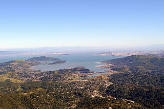
Richardson Bay is a shallow, ecologically rich arm of San Francisco Bay, managed under a Joint Powers Agency of four northern California cities. The 911-acre (369 ha) Richardson Bay Sanctuary was acquired in the early 1960s by the National Audubon Society. The bay was named for William A. Richardson, early 19th century sea captain and builder in San Francisco. It contains both Strawberry Spit and Aramburu Island.
José de la Cruz Sánchez was a Californio statesman and ranchero who served as the eleventh Alcalde of San Francisco.

Arroyo Corte Madera del Presidio is a 4.1-mile-long (6.6 km) year-round stream in southern Marin County, California, United States. This watercourse is also known as Corte Madera Creek, although the actual stream of that name flows into San Francisco Bay further north at Point San Quentin. This watercourse has a catchment basin of about 8 square miles (21 km2) and drains the south-eastern slopes of Mount Tamalpais and much of the area in and around the town of Mill Valley; this stream discharges to Richardson Bay.

Belvedere Island is a rocky island in the San Francisco Bay in Marin County, California which was formerly separated by a marsh from the mainland, though has since been linked by two spits. Part of the town of Belvedere, California is located on the island.

The Tiburon Peninsula is a landform of the San Francisco Bay Area's Marin County and is home to the incorporated municipalities of Tiburon, Belvedere, and a portion of Corte Madera, California. Much of the peninsula is unincorporated, including portions of the north side and the communities of Paradise Cay and Strawberry. Richardson Bay separates the peninsula from the Marin County mainland. Angel Island lies app. 1 mile south of the peninsula's southern tip. Much of the land area of the Tiburon Peninsula was part of a Spanish land grant originally given to the early Californian John Reed. A prominent feature of the Tiburon Peninsula is Ring Mountain, Marin County, which forms the backbone of the peninsula and is the highest elevation of the peninsula. The Tiburon Peninsula is the location of a number of rare and endangered flora species, and is also the site of ancient Native American rock carvings. The mineral lawsonite was first described from an occurrence on the Tiburon Peninsula.

The Lyford House is a Victorian house located in Tiburon, California. Built in 1876, the house is listed on the National Register of Historic Places.
The Ávila family was a prominent Californio family of Spanish origins from Southern California, founded by Cornelio Ávila in the 1780s. Numerous members of the family held important rancho grants and political positions, including two Alcaldes of Los Angeles.
Rancho Corte Madera del Presidio was a 7,845-acre (31.75 km2) Mexican land grant in present day Marin County, California given in 1834 by Governor José Figueroa to John (Juan) Reed. Corte Madera del Presidio means the "lumber mill of the Presidio". The grant encompassed what is now southern Corte Madera, Mill Valley, the Tiburon Peninsula, and Strawberry Point. It reached from Point Tiburon to Larkspur Creek, then known as Arroyo Holon.

Coyote Creek is a stream in the Richardson Bay watershed, draining Tamalpais-Homestead Valley, California eastward into Richardson Bay, Marin County, California, United States. The stream originates on Coyote Ridge and flows 2.5 miles (4.0 km) to the bay at the south end of Bothin Marsh.
Rancho Punta de Quentin was a 8,877-acre (35.92 km2) Mexican land grant in present-day Marin County, California given in 1840 by Governor Juan B. Alvarado to John B.R. Cooper. The grant comprised not only the San Quentin peninsula, but also present-day Ross, Kentfield and part of San Anselmo.
Rancho Corte Madera de Novato was a 8,879-acre (35.93 km2) Mexican land grant in present day Marin County, California given in 1839 by Governor Juan Alvarado to John Martin. The name means the "lumber mill of Novato". The grant extended along Hicks Valley north west of present day Novato.
Rancho Las Posas was a 26,623-acre (107.74 km2) Mexican land grant in present-day Ventura County, California. It was given in 1834 by Governor José Figueroa to José Antonio Carrillo.

Corte Madera Creek is a short stream which flows southeast for 4.5 miles (7.2 km) in Marin County, California. Corte Madera Creek is formed by the confluence of San Anselmo Creek and Ross Creek in Ross and entering a tidal marsh at Kentfield before connecting to San Francisco Bay near Corte Madera.

Larkspur Creek is a short stream which flows 3.5 miles east to meet Corte Madera Creek in Larkspur, California just before reaching Richardson's Bay. The creek was named for the town of Larkspur, which was named by Georgiana Wright, a Briton and spouse of the 1887 developer of the area. She named the town of Larkspur for lupine flowers on the hills that she mistook for larkspur.

Richardson Island is a former island in San Francisco Bay, in northern California. While it was once surrounded by water and marsh, development of surrounding areas caused it to become completely surrounded by land by the mid-20th century. It is located in Marin County, in the city of Corte Madera. The United States Geological Survey (USGS) gave its elevation as 16 ft (4.9 m) in 1981. It is near the end of Corte Madera Creek, where it flows into San Francisco Bay.

Old Mill Creek is a 2.3-mile-long (3.7 km) year-round stream in southern Marin County, California, United States. Old Mill Creek is a tributary to Arroyo Corte Madera del Presidio, which, in turn, flows to Richardson Bay at Mill Valley's municipal Bayfront Park and 106 acres (0.43 km2) Bothin Marsh.
References
- ↑ Corte Madera, 2003
- ↑ Hogle, Gene NAC Green Book of Pacific Coast Touring (1931) National Automobile Club p.41
- ↑ Map of Marin County Ranchos Archived 2016-05-03 at the Wayback Machine
- ↑ C. Michael Hogan (2008) Ring Mountain, The Megalithic Portal, ed. Andy Burnham
- ↑ Marin County State Historical Landmarks, 2008
- ↑ Corte Madera del Presidio (Corte de Madera del Presidio) Rancho
- ↑ A Brief History of Mill Valley by Doris Bassett Archived 2011-07-21 at the Wayback Machine
- ↑ History of early Mill Valley by Henri M. Boussy
- ↑ "San Francisco History Alcaldes & Mayors". Archived from the original on 2019-08-19. Retrieved 2009-08-22.
- ↑ San Francisco History. Seventy-five Years in San Francisco. Appendix H. The First San Francisco Directory. Mission Dolores Archived 2016-10-21 at the Wayback Machine
- ↑ Heirs To Rancho Corte Madera Del Presidio