Fosciandora

Last updated • 2 min readFrom Wikipedia, The Free Encyclopedia
Fosciandora
Comune di Fosciandora
Fosciandora - panorama delle frazioni.JPG
View of two of the frazioni in the municipality, La Villa and Ceserana
Fosciandora-Stemma.png
Location of Fosciandora
Fosciandora
Italy provincial location map 2016.svg
Red pog.svg
Fosciandora
Location of Fosciandora in Italy
Italy Tuscany location map.svg
Red pog.svg
Fosciandora
Fosciandora (Tuscany)
Coordinates: 44°7′N10°28′E / 44.117°N 10.467°E / 44.117; 10.467
Country Italy
Region Tuscany
Province Lucca (LU)
Frazioni Ponte di Ceserana, Ceserana, La Villa, Lupinaia, Fosciandora, Migliano, Treppignana, Riana
Government
  MayorMoreno Lunardi
Area
[1]
  Total19.8 km2 (7.6 sq mi)
Elevation
390 m (1,280 ft)
Population
 (31 May 2023) [2]
  Total554
  Density28/km2 (72/sq mi)
Demonym Fosciandorini
Time zone UTC+1 (CET)
  Summer (DST) UTC+2 (CEST)
Postal code
55020
Dialing code 0583
Website Official website

Fosciandora (Italian pronunciation: [foʃˈʃandora] ) is a comune (municipality) of 554 inhabitants [2] in the Province of Lucca in the Italian region Tuscany, located about 70 kilometres (43 mi) northwest of Florence and about 30 kilometres (19 mi) north of Lucca.

Contents

Fosciandora borders the municipalities of Barga, Castelnuovo di Garfagnana, Gallicano, Pieve Fosciana and Pievepelago.

History

The territory of Fosciandora was annexed by the Republic of Lucca in the 13th century. After the House of Este took control of the Garfagnana region, which took place starting from 1429, Fosciandora was divided between two states. The so-called "three lands", or the centres of Treppignana, Riana and Lupinaia, remained under the jurisdiction of Lucca, forming part of the diocese of Gallicano, while the rest of the current municipality – with Ceserana as its capital – was absorbed into the Republic of Florence and subsequently, in 1451, to Borso d'Este, becoming part of the Duchy of Ferrara. [3]

At the end of the 18th century, the Garfagnana region came under the government of the Cispadane Republic which, on 3 March 1799, ordered that each of the three territories of Ceserana, Villa and Fosciandora should form a comune in their own right. A new law of March 1804 brought together these three small municipalities into a single one, which was given the name of the Comunità di Fosciandora. [4]

In 1847, with the entry into force of the Treaty of Florence, the territory of Fosciandora expanded to its current borders [5] and became a province of the Duchy of Modena and Reggio. This continued until 1859, and subsequently with the proclamation of the Kingdom of Italy became part of the Kingdom of Italy.

In 1923 the entire district of Castelnuovo di Garfagnana (including Fosciandora) passed from the Province of Massa-Carrara to the Province of Lucca.

Monuments and places of interest

Religious architecture

Civil architecture

Transport

Garfagnana regional road 445 crosses the Fosciandora region, on which public bus services are operated by CTT Nord.

The comune is served by Fosciandora-Ceserana railway station on the Lucca–Aulla railway.

Related Research Articles

The Garfagnana is a historical and geographical region of central Italy, today part of the province of Lucca, in Tuscany. It is the upper valley or basin of the river Serchio, and thus lies between the main ridge of the Northern Apennines to the north-east and the Alpi Apuane to the west. The principal towns are Castelnuovo di Garfagnana and Barga.

<span class="mw-page-title-main">Province of Lucca</span> Province of Italy

The province of Lucca is a province in the Tuscany region of Italy. Its capital is the city of Lucca.

<span class="mw-page-title-main">Barga, Tuscany</span> Comune in Tuscany, Italy

Barga is a medieval town and comune of the province of Lucca in Tuscany, central Italy. It is home to around 10,000 people and is the chief town of the "Media Valle" of the Serchio River. It is a member of the I Borghi più belli d'Italia association.

<span class="mw-page-title-main">Serchio</span> River in Italy

The Serchio is the third longest river in the Italian region of Tuscany at 126 kilometres (78 mi), coming after the Arno at 242 kilometres (150 mi) and the Ombrone, 161 kilometres (100 mi). By mean rate of flow, it is the second largest, smaller than Arno but larger than Ombrone.

<span class="mw-page-title-main">Borgo a Mozzano</span> Comune in Tuscany, Italy

Borgo a Mozzano is a town and comune in the province of Lucca, in northern Tuscany (Italy), located on the Serchio River.

Castelnuovo or Castel Nuovo may refer to :

<span class="mw-page-title-main">Camporgiano</span> Comune in Tuscany, Italy

Camporgiano is a comune (municipality) in the Province of Lucca in the Italian region Tuscany, located about 90 kilometres (56 mi) northwest of Florence and about 40 kilometres (25 mi) northwest of Lucca.

<span class="mw-page-title-main">Coreglia Antelminelli</span> Comune in Tuscany, Italy

Coreglia Antelminelli is a comune (municipality) in the Province of Lucca in the Italian region Tuscany, located about 70 kilometres (43 mi) northwest of Florence and about 25 kilometres (16 mi) north of Lucca.

<span class="mw-page-title-main">Gallicano</span> Comune in Tuscany, Italy

Gallicano is a comune (municipality) in the Province of Lucca in the Italian region Tuscany, located about 70 kilometres (43 mi) northwest of Florence and about 25 kilometres (16 mi) northwest of Lucca.

<span class="mw-page-title-main">Molazzana</span> Comune in Tuscany, Italy

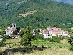
Molazzana is a comune (municipality) in the Province of Lucca in the Italian region Tuscany, located about 70 kilometres (43 mi) northwest of Florence and about 25 kilometres (16 mi) northwest of Lucca.

<span class="mw-page-title-main">Pescaglia</span> Comune in Tuscany, Italy

Pescaglia is a comune (municipality) in the Province of Lucca in the Italian region Tuscany, located about 70 kilometres (43 mi) northwest of Florence and about 15 kilometres (9 mi) northwest of Lucca.

<span class="mw-page-title-main">Pieve Fosciana</span> Comune in Tuscany, Italy

Pieve Fosciana is a comune (municipality) in the Province of Lucca in the Italian region Tuscany, located about 80 kilometres (50 mi) northwest of Florence and about 30 kilometres (19 mi) north of Lucca.

<span class="mw-page-title-main">Villa Collemandina</span> Comune in Tuscany, Italy

Villa Collemandina is a comune (municipality) in the Province of Lucca in the Italian region Tuscany, located about 80 kilometres (50 mi) northwest of Florence and about 35 kilometres (22 mi) north of Lucca.

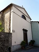
Santi Pietro e Paolo is the Baroque-style Roman Catholic cathedral in the center of the town of Castelnuovo di Garfagnana, region of Tuscany, Italy.

The following is a timeline of the history of the city of Pisa in the Tuscany region of Italy.

<span class="mw-page-title-main">Oratory of Maria Santissima Assunta in Cielo, Retignano</span>

The Chapel of Our Lady's Assumption into Heaven, sometimes spelled as Chapel of Our Lady and also known as Little Church, is a church located in Retignano, a village in the municipality of Stazzema, Italy.

<span class="mw-page-title-main">San Nicola di Silanis</span> Church building in Sedini, Italy

The Chiesa di San Nicola di Silanis is a church in a state of ruins in the comune of Sedini, northern Sardinia, Italy.

<span class="mw-page-title-main">San Pellegrinetto</span> Former Italian comune incorporated into Fabbriche di Vergemoli

San Pellegrinetto was an Italian comune in the Alps of Garfagnana, a historic region of Tuscany, province of Lucca. It was dependent for many years on the comune of Trassilico, time during which it adopted the name Alpe di Trassilico until the creation of its parish. When Trassilico was incorporated as a fraction of Gallicano, so was San Pellegrinetto. It was eventually incorporated into the comune of Fabbriche di Vergemoli.

References

  1. "Superficie di Comuni Province e Regioni italiane al 9 ottobre 2011". Italian National Institute of Statistics. Retrieved 16 March 2019.
  2. 1 2 Istat. "Bilancio demografico mensilee popolazione residente per sesso, anno 2023" (in Italian).
  3. Raffaelli, Raffaello (1879). Descrizione geografica storica economica della Garfagnana (in Italian). p. 178-182.
  4. Raffaelli, Raffaello (1879). Descrizione geografica storica economica della Garfagnana (in Italian). p. 187. Il 3 marzo 1799 una legge speciale del Direttorio di Milano ordinò che ciascuna delle tre Terre di Ceserana, di Villa e di Fosciandora dovesse formare un Comune a sè, e che tutte avessero il proprio Agente Municipale ed un Aggiunto. Una nuova legge peraltro del marzo 1804 riuniva questi tre piccoli Comuni in uno solo, a cui fu dato il nome di Comunità di Fosciandora, ed alla quale vennero pure aggregati i paesi del Sillico e di Bargecchia. [...] Il Sillico e Bargecchia ne furono poi staccati per decreto de' 29 ottobre 1808, quando da Felice I si riformò la circoscrizione amministrativa del Principato Lucchese.
  5. Raffaelli, Raffaello (1879). Descrizione geografica storica economica della Garfagnana (in Italian). p. 187. Il Comune di Fosciandora venne accresciuto nel 1846 coll'aggiunta delle frazioni limitrofe di Lupinaia, Riana e Treppignana, le quali per lo addietro avevano appartenuto quando a Pievefosciana, quando a Castiglione e quando a Gallicano.