
Telve is a comune (municipality) in Trentino in the northern Italian region Trentino-Alto Adige/Südtirol, located about 30 kilometres (19 mi) east of Trento. As of 31 December 2004, it had a population of 1,914 and an area of 64.8 square kilometres (25.0 sq mi).

Pieve di Teco is a comune (municipality) in the Province of Imperia in the Italian region Liguria, located about 90 kilometres (56 mi) southwest of Genoa and about 20 kilometres (12 mi) northwest of Imperia.
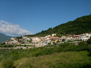
Pornassio is a comune (municipality) in the Province of Imperia in the Italian region Liguria, located about 90 kilometres (56 mi) southwest of Genoa and about 25 kilometres (16 mi) northwest of Imperia. As of 31 December 2004, it had a population of 642 and an area of 27.7 square kilometres (10.7 sq mi).

Pieve Emanuele is a comune (municipality) in the Italian region of Lombardy, located about 13 kilometres (8 mi) south of Milan, and about 20 kilometres (12 mi) north of Pavia.

Almenno San Salvatore is a comune (municipality) in the Province of Bergamo in the Italian region Lombardy, located about 45 kilometres (28 mi) northeast of Milan and about 9 kilometres (6 mi) northwest of Bergamo.
Dorno is a comune (municipality) in the Province of Pavia in the Italian region Lombardy, located about 40 kilometres (25 mi) southwest of Milan and about 15 kilometres (9 mi) west of Pavia. As of 31 December 2004, it had a population of 4,415 and an area of 30.6 square kilometres (11.8 sq mi).
Cicognolo is a comune (municipality) in the Province of Cremona in the Italian region Lombardy, located about 90 kilometres (56 mi) southeast of Milan and about 14 kilometres (9 mi) northeast of Cremona. As of 31 December 2012, it had a population of 961 and an area of 7.0 square kilometres (2.7 sq mi).
Ostiano is a comune (municipality) in the Province of Cremona in the Italian region Lombardy, located about 90 kilometres (56 mi) southeast of Milan and about 20 kilometres (12 mi) northeast of Cremona. As of 31 December 2004, it had a population of 3,054 and an area of 19.4 square kilometres (7.5 sq mi).
Curtarolo is a comune (municipality) in the Province of Padua in the Italian region Veneto, located about 40 kilometres (25 mi) west of Venice and about 11 kilometres (7 mi) north of Padua. As of 31 December 2004, it had a population of 6,775 and an area of 14.9 square kilometres (5.8 sq mi).

Terenzo is a comune (municipality) in the Province of Parma in the Italian region Emilia-Romagna, located about 100 kilometres (62 mi) west of Bologna and about 30 kilometres (19 mi) southwest of Parma. As of 31 December 2004, it had a population of 1,250 and an area of 72.4 square kilometres (28.0 sq mi).

Camporgiano is a comune (municipality) in the Province of Lucca in the Italian region Tuscany, located about 90 kilometres (56 mi) northwest of Florence and about 40 kilometres (25 mi) northwest of Lucca.

Fosciandora is a comune (municipality) of 670 inhabitants in the Province of Lucca in the Italian region Tuscany, located about 70 kilometres (43 mi) northwest of Florence and about 30 kilometres (19 mi) north of Lucca.

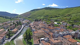
Gallicano is a comune (municipality) in the Province of Lucca in the Italian region Tuscany, located about 70 kilometres (43 mi) northwest of Florence and about 25 kilometres (16 mi) northwest of Lucca.

Molazzana is a comune (municipality) in the Province of Lucca in the Italian region Tuscany, located about 70 kilometres (43 mi) northwest of Florence and about 25 kilometres (16 mi) northwest of Lucca.
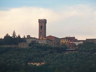
Montecarlo is a comune (municipality) in the Province of Lucca in the Italian region Tuscany, located about 50 kilometres (31 mi) west of Florence and about 12 kilometres (7 mi) east of Lucca.

Piazza al Serchio is a comune (municipality) in the Province of Lucca in the Italian region Tuscany, located about 90 kilometres (56 mi) northwest of Florence and about 40 kilometres (25 mi) northwest of Lucca.

San Romano in Garfagnana is a comune (municipality) in the Province of Lucca in the Italian region Tuscany, located about 80 kilometres (50 mi) northwest of Florence and about 40 kilometres (25 mi) northwest of Lucca.

Villa Collemandina is a comune (municipality) in the Province of Lucca in the Italian region Tuscany, located about 80 kilometres (50 mi) northwest of Florence and about 35 kilometres (22 mi) north of Lucca.

Calenzano is a comune (municipality) in the Metropolitan City of Florence in the Italian region Tuscany, located about 11 kilometres (7 mi) northwest of Florence. As of 31 December 2004, it had a population of 15,557 and an area of 76.9 square kilometres (29.7 sq mi).
Pieve Santo Stefano is a comune (municipality) in the Province of Arezzo in the Italian region Tuscany, located about 70 kilometres (43 mi) east of Florence and about 25 kilometres (16 mi) northeast of Arezzo.


