Palauli

Last updated
Palauli
District
Blowholes and people - Palauli - Samoa.jpg
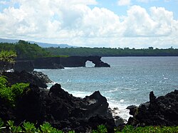
Taga blowholes on the coast.
Samoa-Palauli.png
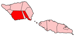
Map of Samoa showing Palauli district
Country Flag of Samoa.svg  Samoa
Population
 (2016)
  Total9,300
Time zone -11

Palauli is a district and village of Samoa, with a population (2016 Census) of 9,300. It consists of two sections on the southern side of Savai'i. The capital is Vailoa which is also referred to as Vailoa i Palauli (Vailoa in Palauli district).

Contents

Geological formations of lava tubes have created the Taga Blowholes on the coast of Taga village and attracts visitors and tourists.

In recent years, the inland village of Sili has refused the government of Samoa from building a hydro power plant on traditional land due to conservation and cultural concerns. [1]

The paramount title of this district is Lilomaiava,[ citation needed ] which is conferred in Vailoa. As part of the selection process for the title-holder, Vailoa must consult with Safotu village in the Gagaifomauga political district. Safotu is the northern base of the Lilomaiava title in Savai'i.

Archaeology

Extensive pre-historic settlements have been surveyed and studied in the Palauli district where the Pulemelei Mound is situated. [2]

Notable people

See also

Related Research Articles

Pulemelei Mound

The Pulemelei mound is the largest and most ancient structure in the Samoan Islands. It is situated in Letolo Plantation in the Palauli district, at the east end of Savai'i island in Samoa.

Satupaʻitea District in Samoa

Satupaʻitea is a large village district with four sub-villages on the south east coast of Savaiʻi Island in Samoa.

Neiafu, Samoa

Neiafu is a village on the island of Savai'i in Samoa. It is in the Alataua Sisifo electoral district and located at the south west corner of the island. The population of Neiafu Uta is 601 and Neiafu Tai is 307.

Taga, Samoa

Taga is a village on the island of Savai'i in Samoa. It is situated on the south coast of the island in the district of Palauli and the electoral district of Palauli 1. The population is 785.

Uale Mai Rugby player

Uale Mai Vala is a retired rugby union player who played for the country's national teams, Manu Samoa and Samoa Sevens. He is a former captain of the Samoa Sevens team which represent Samoa internationally in the IRB Sevens World Series. He was at the time of his retirement sevens rugby's most capped player, and Mai is considered one of the greats in the international sport. Mai has been one of the top points scorers in the IRB World Sevens Series.

Archaeology of Samoa

Archaeology of Samoa began with the first systematic survey of archaeological remains on Savai'i island by Jack Golson in 1957. Since then, surveys and studies in the rest of Samoa have uncovered major findings of settlements, stone and earth mounds including star mounds, Lapita pottery remains and pre-historic artifacts.

Gregory Jackmond is an American who carried out extensive archaeological field work in Samoa during the 1970s.

Vailoa is a village on the island of Savai'i in Samoa. Vailoa is the capital of Palauli district on the south east of the island. The population is 784.

Satufia is a village on the island of Savai'i in Samoa. It is situated on the south coast of the island in the district of Satupa'itea and the electoral district of Satupa'itea. The population is 573.

Vaega is a village on the island of Savai'i in Samoa. It is situated on the south coast of the island in the district of Satupa'itea and the electoral district of Satupa'itea. The population is 571.

Moasula is a village on the island of Savai'i in Samoa. It is situated on the south coast of the island in the district of Satupa'itea. The population is 685.

Pitonu'u is a village on the island of Savai'i in Samoa. It is situated on the south coast of the island in the district of Satupa'itea and the electoral district of Satupa'itea. The population is 283.

Samata-i-Uta is a village on the island of Savai'i in Samoa. It is situated on the south coast of the island in the district of Satupa'itea and the electoral district of Salega 1. The population is 646.

Samata-i-Tai is a village on the island of Savai'i in Samoa. It is situated on the south coast of the island in the district of Satupa'itea and the electoral district of Salega 1. The population is 416.

Fogasavai'i is a village on the island of Savai'i in Samoa. It is situated on the south coast of the island in the district of Satupa'itea and the electoral district of Salega 2. The population is 354.

Vaipua is a village on the island of Savai'i in Samoa. It is situated on the south coast of the island in the district of Satupa'itea and the electoral district of Salega 2. The population is 426.

Fai'a'ai is a village on the island of Savai'i in Samoa. It is situated on the south coast of the island in the district of Satupa'itea and the electoral district of Salega 1. The population is 397.

Fagafau is a village on the island of Savai'i in Samoa. It is situated on the south coast of the island in the district of Satupa'itea and the electoral district of Salega 1. The population is 240.

The Lata River is a river on the island of Savai'i in the Pacific island nation of Samoa. It is located in the south of the island, flowing through the Palauli district.

References

  1. "Samoa's Sili hydro plan scuttled, 12 March 2004 UTC". Radio New Zealand International. Retrieved 23 November 2009.
  2. Samoan Village Patterns: Four Examples by Jesse D. Jennings, Richard Holmer and Gregory Jackmond, University of Utah, Journal of the Polynesian Society, Vol. 91, No. 1, 1982. Retrieved 6 November 2009
  3. "Mai returns as squads declared for NZI Sevens". International Rugby Board, News. 4 February 2010. Archived from the original on 10 February 2010. Retrieved 2 April 2010.

Coordinates: 13°42′S172°28′W / 13.700°S 172.467°W / -13.700; -172.467