Blera

Last updated
Blera
Comune di Blera
Blera.jpg
Blera and the Fascist built bridge.
Blera-Stemma.png
Location of Blera
Blera
Italy provincial location map 2016.svg
Red pog.svg
Blera
Location of Blera in Italy
Italy Lazio location map.svg
Red pog.svg
Blera
Blera (Lazio)
Coordinates: 42°16′24″N12°01′57″E / 42.27333°N 12.03250°E / 42.27333; 12.03250
Country Italy
Region Lazio
Province Viterbo (VT)
Frazioni Civitella Cesi
Government
  MayorNicola Mazzarella
Area
[1]
  Total92.92 km2 (35.88 sq mi)
Elevation
270 m (890 ft)
Population
 (30 April 2017) [2]
  Total3,316
  Density36/km2 (92/sq mi)
Demonym Blerani
Time zone UTC+1 (CET)
  Summer (DST) UTC+2 (CEST)
Postal code
01010
Dialing code 0761
Patron saintSt. Viventius
Saint dayDecember 11
Website Official website

Blera is a small town and comune in the northern Lazio region of Italy. It was known during the Middle Ages as Bieda, an evolved form of its ancient name, which was restored in the twentieth century. It is the birthplace of Pope Sabinian; Pope Paschal II was also originally thought to be from here.

Contents

It is situated on a long, narrow tongue of rock at the junction of two deep glens. [3]

History

In ancient times, Blera was an Etruscan town on the Via Clodia. It was of little importance, and is known to be mentioned only by geographers and in inscriptions. [3]

In 772, it was destroyed by the Lombards of King Desiderius. In the thirteenth-fifteenth centuries, it belonged to the Di Vico family. In 1247 the army of Frederick II ravaged it. In the fifteenth century, Pope Boniface IX gave Blera to the Anguillara family, who owned it until 1572, apart from a short period from 1465 under direct Papal control. Later it followed the history of the Papal States.

Main sights

Some remains of the town walls still exist, and also two ancient bridges, both belonging to the Via Clodia, and many tombs hewn in the rock with small chambers imitating the architectural forms of houses, and beams and rafters represented in relief. [3]

Selvasecca di Blera

Eric Berggren and the Swedish Institute in Rome excavated a Republican period rural structure or villa at the site of Selvasecca di Blera between 1965 and 1967, with preliminary results published in 1969. [4] [5] The hill of Selvasecca lies about 6 km southwest of Blera itself. [6] The villa site is marked by a courtyard building that includes a remarkable vaulted cistern built using opus caementicium . There is also evidence that architectural terracottas were produced at the site. [7] The implications of the villa itself have been recently re-visited. [8]

Related Research Articles

<span class="mw-page-title-main">Anzio</span> Comune in Lazio, Italy

Anzio is a town and comune on the coast of the Lazio region of Italy, about 51 kilometres (32 mi) south of Rome.

<span class="mw-page-title-main">Palestrina</span> Comune in Lazio, Italy

Palestrina is a modern Italian city and comune (municipality) with a population of about 22,000, in Lazio, about 35 kilometres east of Rome. It is connected to the latter by the Via Prenestina. It is built upon the ruins of the ancient city of Praeneste.

<span class="mw-page-title-main">Antium</span> Former human settlement and archaeological site near Rome

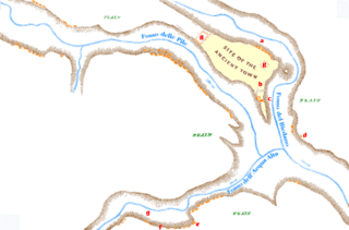
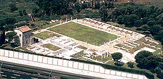
Antium was an ancient coastal town in Latium, south of Rome. An oppidum was founded by people of Latial culture, then it was the main stronghold of the Volsci people until it was conquered by the Romans.

<span class="mw-page-title-main">Civitavecchia</span> Comune in Lazio, Italy

Civitavecchia is a city and comune of the Metropolitan City of Rome in the central Italian region of Lazio. A sea port on the Tyrrhenian Sea, it is located 60 kilometres west-north-west of Rome. The harbour is formed by two piers and a breakwater, on which stands a lighthouse.

<span class="mw-page-title-main">Via Clodia</span>

The Via Clodia was an ancient high-road of Italy. Situated between the Via Cassia and the Via Aurelia, it is different from them notably in that the latter was designed primarily for military long-haul, irrespective of settlements they met, but the Via Clodia was of short-range, intended for commercial traffic with the colonies in Etruscan lands.

<span class="mw-page-title-main">Bolsena</span> Comune in Lazio, Italy

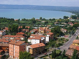
Bolsena is a town and comune of Italy, in the province of Viterbo in northern Lazio on the eastern shore of Lake Bolsena. It is 10 km (6 mi) north-north west of Montefiascone and 36 km (22 mi) north-west of Viterbo. The ancient Via Cassia, today's highway SR143, follows the lake shore for some distance, passing through Bolsena. Bolsena is named "the city of the Eucharistic miracle" from which the solemnity of Corpus Domini had been extended to the whole Roman Catholic Church.

<span class="mw-page-title-main">Formello</span> Comune in Lazio, Italy

Formello is a town and comune in the Metropolitan City of Rome. It is located southwest of the Monti Sabatini, within the Regional Park of Veii. The communal territory sits on large deposits of tuff, which is intensively mined in the area.

<span class="mw-page-title-main">Tuscania</span> Comune in Lazio, Italy

Tuscania is a town and comune in the province of Viterbo, Lazio Region, Italy. Until the late 19th century the town was known as Toscanella.

<span class="mw-page-title-main">Villanovan culture</span> Iron age culture in Italy

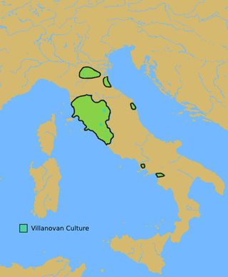
The Villanovan culture, regarded as the earliest phase of the Etruscan civilization, was the earliest Iron Age culture of Italy. It directly followed the Bronze Age Proto-Villanovan culture which branched off from the Urnfield culture of Central Europe. The name derives from the locality of Villanova, a fraction of the municipality of Castenaso in the Metropolitan City of Bologna where, between 1853 and 1855, Giovanni Gozzadini found the remains of a necropolis, bringing to light 193 tombs, of which there were 179 cremations and 14 inhumations.

<span class="mw-page-title-main">Saturnia</span> Frazione in Tuscany, Italy

Saturnia is a spa town in Tuscany in north-central Italy that has been inhabited since ancient times. It is a frazione of the comune of Manciano, in the province of Grosseto. Famous for the spa which gives it its name, its population is 280.

<span class="mw-page-title-main">Lucus Feroniae</span> Archaeological site in Capena, Italy

Lucus Feroniae was an ancient sanctuary or, literally sacred grove ("lucus"), dedicated to the Sabine goddess Feronia, protector of freedmen, ex-slaves. It was located near to the ancient town of Feronia in Etruria on the ancient Via Tiberina, in what is now the territory of the modern commune of Capena, Lazio.

<span class="mw-page-title-main">Ranuccio Bianchi Bandinelli</span> Italian archaeologist and historian

Ranuccio Bianchi Bandinelli was an Italian archaeologist and art historian.

Giovanni Becatti was an Italian Classical art historian and archaeologist.

<span class="mw-page-title-main">Orte</span> Comune in Lazio, Italy

Orte is a town, comune, former Catholic bishopric and Latin titular see in the province of Viterbo, in the central Italian region of Lazio, located about 60 kilometres (37 mi) north of Rome and about 24 kilometres (15 mi) east of Viterbo.

<span class="mw-page-title-main">Feronia (Etruria)</span> Ancient city in Etruria

Feronia or Lucus Feroniae was an ancient town near the present town of Fiano Romano. It is located in the plain along the Tiber river, at the foot of Mount Soracte, and was within the ancient territory of Capena. It began as a sanctuary called Lucus Feroniae in the time of Tullus Hostilius when it was located in Etruria.

<span class="mw-page-title-main">National Etruscan Museum</span> Archaeological museum in Rome

The National Etruscan Museum is a museum of the Etruscan civilization, housed in the Villa Giulia in Rome, Italy.

<span class="mw-page-title-main">Luni, Italy</span> Comune in Liguria, Italy

Luni is a comune (municipality) in the province of La Spezia, in the easternmost end of the Liguria region of northern Italy. It was founded by the Romans as Luna. It gives its name to Lunigiana, a region spanning eastern Liguria and northern Tuscany.

<span class="mw-page-title-main">San Giovenale</span>

San Giovenale is the modern name of the location of an ancient Etruscan settlement close to the modern village of Blera, Italy. It was excavated by the Swedish Institute at Rome in the 1950s and 1960s with King Gustaf VI Adolf as one of the participating archaeologists. The excavations at San Giovenale has been, together with the excavations of Acquarossa, the main source of information about how small and medium-size Etruscan settlements were organized. The finds from the excavations are now partly exhibited in the Etruscan Museum of the Rocca Albornoz in Viterbo.

<span class="mw-page-title-main">Norchia</span>

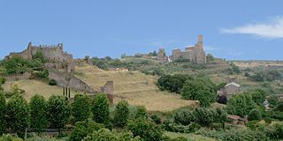
Norchia is an ancient Etruscan city with an adjacent necropolis, near Vetralla in Italy. The site is along the Via Clodia, and is not far from the more well known Etruscan town of Tarquinia.

<span class="mw-page-title-main">Villa dei Volusii</span>

The ancient Roman Villa dei Volusii or Villa dei Volusii-Saturnini is an archaeological site located in the municipality of Fiano Romano, next to the ancient Roman town and sanctuary of Lucus Feroniae, along the route of ancient Via Tiberina.

References

  1. "Superficie di Comuni Province e Regioni italiane al 9 ottobre 2011". Italian National Institute of Statistics. Retrieved 16 March 2019.
  2. "Popolazione Residente al 1° Gennaio 2018". Italian National Institute of Statistics. Retrieved 16 March 2019.
  3. 1 2 3 Wikisource-logo.svg One or more of the preceding sentences incorporates text from a publication now in the public domain :  Chisholm, Hugh, ed. (1911). "Blera". Encyclopædia Britannica . Vol. 4 (11th ed.). Cambridge University Press. p. 58. This cites Dennis, G. Cities and Cemeteries of Etruria.
  4. Jane DeRose Evans (29 March 2013). A Companion to the Archaeology of the Roman Republic. John Wiley & Sons. pp. 369–. ISBN   978-1-118-55716-7.
  5. E. Berggren and A. Andrén. 1969. "Blera (Località Selvasecca). Villa rustica etrusco-romana con manifattura di terrecotte architettoniche templari." Notizie degli Scavi 1969, pp. 59-71.
  6. Enciclopedia dell' Arte Antica (1973): SELVASECCA http://www.treccani.it/enciclopedia/selvasecca_%28Enciclopedia-dell%27-Arte-Antica%29/
  7. Martin Söderlind (2002). Late Etruscan Votive Heads from Tessennano: Production, Distribution, Sociohistorical Context. L'ERMA di BRETSCHNEIDER. pp. 317–. ISBN   978-88-8265-186-2.
  8. Opuscula Romana. C. W. K. Gleerup. 2006.