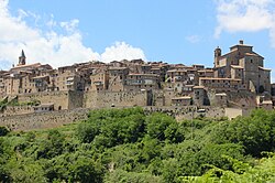
Arlena di Castro is a comune (municipality) in the Province of Viterbo in the Italian region of Latium, located about 80 kilometres (50 mi) northwest of Rome and about 15 kilometres (9 mi) west of Viterbo.
Canepina is a comune (municipality) in the Province of Viterbo in the Italian region of Latium, located about 60 kilometres (37 mi) northwest of Rome and about 11 kilometres (7 mi) southeast of Viterbo. The town derives its name from the once locally widespread cultivation of hemp, which was particularly renowned for its pure white color.
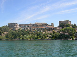
Capodimonte is a comune (municipality) in the Province of Viterbo in the Italian region Lazio, located about 90 kilometres (56 mi) northwest of Rome and about 20 kilometres (12 mi) northwest of Viterbo. It is on the southwestern shore of Lake Bolsena. In contrast to the other communities on the lake, Capodimonte has a headland with a sheltered harbor.
Carbognano is a comune (municipality) in the Province of Viterbo in the Italian region of Latium, located about 50 kilometres (31 mi) northwest of Rome and about 15 kilometres (9 mi) southeast of Viterbo. As of 31 December 2004, it had a population of 1,992 and an area of 17.2 square kilometres (6.6 sq mi).
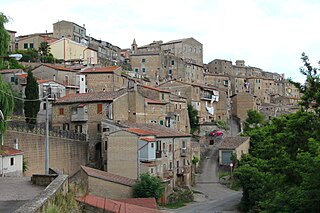
Celleno is a comune (municipality) of 1 297 inhabitants in the Province of Viterbo in the Italian region Lazio, located about 80 kilometres (50 mi) northwest of Rome and about 15 kilometres (9 mi) north of Viterbo. It was the site of the first battle by South African troops in Italy during the Second World War.
Cellere is a comune (municipality) in the Province of Viterbo in the Italian region of Latium, located about 90 kilometres (56 mi) northwest of Rome and about 30 kilometres (19 mi) northwest of Viterbo.

Civitella d'Agliano is a comune (municipality) in the Province of Viterbo in the Italian region of Latium, located about 80 kilometres (50 mi) northwest of Rome and about 20 kilometres (12 mi) northeast of Viterbo.

Fabrica di Roma is a comune (municipality) in the Province of Viterbo in the Italian region of Latium, located about 55 kilometres (34 mi) northwest of Rome and about 25 kilometres (16 mi) south-east of Viterbo.

Farnese is a comune (municipality) in the Province of Viterbo in the Italian region of Latium, located about 100 kilometres (62 mi) northwest of Rome and about 35 kilometres (22 mi) northwest of Viterbo.

Graffignano is a comune (municipality) in the Province of Viterbo in the Italian region of Latium, located about 80 kilometres (50 mi) northwest of Rome and about 20 kilometres (12 mi) northeast of Viterbo.
Ischia di Castro is a comune (municipality) in the Province of Viterbo in the Italian region of Latium, located about 90 kilometres (56 mi) northwest of Rome and about 30 kilometres (19 mi) northwest of Viterbo.

Lubriano is a comune (municipality) of about 900 inhabitants in the Province of Viterbo in the Italian region of Latium, located about 90 kilometres (56 mi) northwest of Rome and about 25 kilometres (16 mi) north of Viterbo.

Marta is a comune (municipality) in the Province of Viterbo in the Italian region of Latium, located about 80 kilometres (50 mi) northwest of Rome and about 20 kilometres (12 mi) northwest of Viterbo.
Onano is a comune (municipality) in the Province of Viterbo in the Italian region Lazio, located about 100 kilometres (62 mi) northwest of Rome and about 40 kilometres (25 mi) northwest of Viterbo.
Piansano is a comune (municipality) in the Province of Viterbo in the Italian region of Latium, located about 90 kilometres (56 mi) northwest of Rome and about 25 kilometres (16 mi) northwest of Viterbo. As of 31 December 2004, it had a population of 2,232 and an area of 26.5 square kilometres (10.2 sq mi).

Proceno is a comune (municipality) in the Province of Viterbo in the Italian region of Latium, located about 110 kilometres (68 mi) northwest of Rome and about 45 kilometres (28 mi) northwest of Viterbo.
Tessennano is a comune (municipality) in the Province of Viterbo in the Italian region of Latium, located about 90 kilometres (56 mi) northwest of Rome and about 25 kilometres (16 mi) west of Viterbo.

Vallerano is a comune (municipality) in the Province of Viterbo in the Italian region of Latium, located about 60 kilometres (37 mi) northwest of Rome and about 13 kilometres (8 mi) southeast of Viterbo.

Vignanello is a comune (municipality) in the Province of Viterbo in the Italian region of Latium, located about 60 kilometres (37 mi) northwest of Rome and about 14 kilometres (9 mi) southeast of Viterbo.

Vitorchiano is a comune (municipality) in the Province of Viterbo in the Italian region of Latium, located about 70 kilometres (43 mi) northwest of Rome and about 7 kilometres (4 mi) northeast of Viterbo. As of 31 December 2004, it had a population of 3,690 and an area of 29.8 square kilometres (11.5 sq mi).