Princeton Township, New Jersey

Last updated

Princeton Township, New Jersey
Mercer County New Jersey incorporated and unincorporated areas Princeton highlighted.svg
Location of Princeton Township and Borough in Mercer County highlighted in red (right). Inset map: Location of Mercer County in New Jersey highlighted in orange (left).
Census Bureau map of Princeton Township, New Jersey.png
Census Bureau map of Princeton Township, New Jersey
Coordinates: 40°21′26″N74°40′13″W / 40.357115°N 74.670165°W / 40.357115; -74.670165
Country Flag of the United States.svg  United States
State Flag of New Jersey.svg  New Jersey
County Mercer
Settled1683
Incorporated April 9, 1838
DisestablishedJanuary 1, 2013
Government
[1]
  Type Township
  BodyTownship Committee
   Mayor Chad Goerner (D, term ended December 31, 2012) [2] [3]
   Administrator Kathryn Monzo (acting) [4]
   Clerk Linda McDermott [5]
Area
[6]
  Total16.520 sq mi (42.786 km2)
  Land16.090 sq mi (41.672 km2)
  Water0.430 sq mi (1.114 km2)  2.60%
  Rank167th of 566 in state
6th of 13 in county [6]
Elevation
[7]
200 ft (61 m)
Population
  Total16,265
  Rank154th of 566 in state
8th of 13 in county
  Density1,010.9/sq mi (390.3/km2)
   Rank379th of 566 in state
11th of 13 in county
Time zone UTC−05:00 (Eastern (EST))
  Summer (DST) UTC−04:00 (Eastern (EDT))
ZIP Codes
08540-08544 [10]
Area code 609
FIPS code 3402160915 [6] [11] [12]
GNIS feature ID0882125 [6] [13]
Website www.princetontownship.org

Princeton Township was a township in Mercer County, in the U.S. state of New Jersey, that existed from 1838 until the end of 2012. On January 1, 2013, it merged with the Borough of Princeton to form Princeton, New Jersey; both Princeton Township and the Borough of Princeton were dissolved in the merger.

Contents

As of the 2010 United States Census, the township's population was 16,265, [8] [9] reflecting an increase of 238 (+1.5%) from the 16,027 counted in the 2000 census, which had in turn increased by 2,829 (+21.4%) from the 13,198 counted in the 1990 Census. [14]

Princeton was incorporated as a township by an act of the New Jersey Legislature on April 9, 1838, from portions of West Windsor Township in Mercer County and Montgomery Township in Somerset County. The Borough of Princeton created on February 11, 1813 within the area that later became Princeton Township became a fully independent municipality circa 1894. Portions of territory were ceded to the Borough of Princeton on January 4, 1928 and August 21, 1951. [15] On November 8, 2011, voters in Princeton Township voted to consolidate with Princeton Borough, a change that took effect on January 1, 2013. [16]

The Institute for Advanced Study, a private research institution that has been an academic home to Albert Einstein, Kurt Gödel, and many other famous and prize-winning scientists, is located in the former township. Princeton University is located mostly within the former borough, but parts of the campus extended into what was Princeton Township.

Drumthwacket, the official residence of the governor of New Jersey, is located at 344 Stockton Street in the area of the former township. [17]

The last day Princeton Township existed as an independent municipality was December 31, 2012.

Geography

According to the United States Census Bureau, the township had a total area of 16.520 square miles (42.786 km2), including 16.090 square miles (41.672 km2) of it is land and 0.430 square miles (1.114 km2) of water (2.60%) is water. [6] [18]

Princeton Borough was an independent municipality completely surrounded by the township.

Princeton North was an unincorporated community located within Princeton Township that had been a census-designated place until the 2010 Census. [19]

The Princeton Airport is within Princeton's postal district but is situated less than a mile across the Somerset County border, in Montgomery Township.

Demographics

Historical population
CensusPop.Note
1870 1,188
1880 1,139−4.1%
1890 809−29.0%
1900 95518.0%
1910 1,17823.4%
1920 1,42420.9%
1930 2,73892.3%
1940 3,25118.7%
1950 5,40766.3%
1960 10,41192.5%
1970 13,65131.1%
1980 13,6830.2%
1990 13,198−3.5%
2000 16,02721.4%
2010 16,2651.5%
2011 (est.)16,304 [20] 0.2%
Population sources:
1870 [21] 1880-1890 [22]
1890-1910 [23] 1910-1930 [24]
1930-1990 [25] 2000 [26] [27] 2010 [8] [9]

2010 census

The 2010 United States census counted 16,265 people, 6,360 households, and 4,325 families in the township. The population density was 1,010.9 per square mile (390.3/km2). There were 6,814 housing units at an average density of 423.5 per square mile (163.5/km2). The racial makeup was 75.52% (12,283) White, 4.98% (810) Black or African American, 0.14% (22) Native American, 14.17% (2,305) Asian, 0.02% (4) Pacific Islander, 2.26% (368) from other races, and 2.91% (473) from two or more races. Hispanic or Latino of any race were 6.91% (1,124) of the population. [8]

Of the 6,360 households, 31.4% had children under the age of 18; 59.1% were married couples living together; 7.0% had a female householder with no husband present and 32.0% were non-families. Of all households, 23.6% were made up of individuals and 8.8% had someone living alone who was 65 years of age or older. The average household size was 2.52 and the average family size was 3.02. [8]

23.1% of the population were under the age of 18, 6.5% from 18 to 24, 23.7% from 25 to 44, 29.7% from 45 to 64, and 17.0% who were 65 years of age or older. The median age was 42.6 years. For every 100 females, the population had 94.0 males. For every 100 females ages 18 and older there were 90.8 males. [8]

The Census Bureau's 2006-2010 American Community Survey showed that (in 2010 inflation-adjusted dollars) median household income was $107,071 (with a margin of error of +/- $12,828) and the median family income was $149,948 (+/- $16,625). Males had a median income of $112,282 (+/- $7,079) versus $66,150 (+/- $11,617) for females. The per capita income for the borough was $71,050 (+/- $6,509). About 6.2% of families and 7.7% of the population were below the poverty line, including 6.1% of those under age 18 and 6.2% of those age 65 or over. [28]

2000 census

As of the 2000 United States Census [11] there were 16,027 people, 6,044 households, and 4,357 families residing in the township. The population density was 978.2 inhabitants per square mile (377.7/km2). There were 6,224 housing units at an average density of 379.9 per square mile (146.7/km2). The racial makeup of the township was 79.91% White, 5.32% African American, 0.12% Native American, 9.98% Asian, 0.05% Pacific Islander, 2.11% from other races, and 2.51% from two or more races. Hispanic or Latino of any race were 5.28% of the population. [26] [27]

There were 6,044 households, out of which 34.1% had children under the age of 18 living with them, 63.3% were married couples living together, 7.2% had a female householder with no husband present, and 27.9% were non-families. 20.6% of all households were made up of individuals, and 8.2% had someone living alone who was 65 years of age or older. The average household size was 2.57 and the average family size was 2.98. [26] [27]

In the township the population was spread out, with 24.4% under the age of 18, 5.1% from 18 to 24, 27.4% from 25 to 44, 27.7% from 45 to 64, and 15.4% who were 65 years of age or older. The median age was 41 years. For every 100 females, there were 93.6 males. For every 100 females age 18 and over, there were 90.6 males. [26] [27]

The median income for a household in the township was $94,580, and the median income for a family was $123,098. Males had a median income of $77,845 versus $41,563 for females. The per capita income for the township was $56,360. About 4.2% of families and 5.7% of the population were below the poverty line, including 5.7% of those under age 18 and 3.0% of those age 65 or over. [26] [27]

As of the 2000 Census, Princeton Township was the 25th-wealthiest community in the state of New Jersey with a per capita money income of $56,360 as of 1999, an increase of 41.7% from the $39,767 recorded in 1989 when it was ranked 21st in the state. [29]

Climate

According to the Köppen climate classification system, Princeton Township has a Hot-summer Humid continental climate (Dfa).

Climate data for Princeton Twp (40.3575, -74.6673), Elevation 128 ft (39 m), 1991–2020 normals, extremes 1981–2022
MonthJanFebMarAprMayJunJulAugSepOctNovDecYear
Record high °F (°C)71.1
(21.7)
77.6
(25.3)
87.5
(30.8)
94.5
(34.7)
95.1
(35.1)
96.8
(36.0)
102.2
(39.0)
99.9
(37.7)
97.1
(36.2)
92.9
(33.8)
80.1
(26.7)
75.1
(23.9)
102.2
(39.0)
Mean daily maximum °F (°C)39.8
(4.3)
42.3
(5.7)
50.3
(10.2)
62.6
(17.0)
72.3
(22.4)
81.4
(27.4)
86.1
(30.1)
84.3
(29.1)
77.8
(25.4)
65.8
(18.8)
55.0
(12.8)
44.8
(7.1)
63.6
(17.6)
Mean daily minimum °F (°C)22.7
(−5.2)
24.1
(−4.4)
31.1
(−0.5)
41.0
(5.0)
50.7
(10.4)
59.9
(15.5)
65.1
(18.4)
63.4
(17.4)
56.2
(13.4)
44.6
(7.0)
34.9
(1.6)
27.9
(−2.3)
43.6
(6.4)
Record low °F (°C)−12.1
(−24.5)
−3.4
(−19.7)
2.7
(−16.3)
17.4
(−8.1)
31.5
(−0.3)
40.4
(4.7)
46.6
(8.1)
40.9
(4.9)
34.9
(1.6)
23.9
(−4.5)
9.4
(−12.6)
−0.3
(−17.9)
−12.1
(−24.5)
Average precipitation inches (mm)3.59
(91)
2.82
(72)
4.26
(108)
3.77
(96)
4.09
(104)
4.58
(116)
5.00
(127)
4.48
(114)
4.24
(108)
4.17
(106)
3.37
(86)
4.41
(112)
48.79
(1,239)
Average snowfall inches (cm)8.2
(21)
8.7
(22)
4.2
(11)
0.2
(0.51)
0.0
(0.0)
0.0
(0.0)
0.0
(0.0)
0.0
(0.0)
0.0
(0.0)
0.2
(0.51)
0.7
(1.8)
3.7
(9.4)
26.0
(66)
Average dew point °F (°C)21.2
(−6.0)
21.8
(−5.7)
27.2
(−2.7)
36.8
(2.7)
48.8
(9.3)
59.2
(15.1)
64.1
(17.8)
63.4
(17.4)
57.3
(14.1)
45.8
(7.7)
34.5
(1.4)
26.9
(−2.8)
42.4
(5.8)
Source 1: PRISM [30]
Source 2: NOHRSC (Snow, 2008/2009 - 2022/2023 normals) [31]

Ecology

According to the A. W. Kuchler U.S. potential natural vegetation types, Princetown Township would have a dominant vegetation type of Appalachian Oak (104) with a dominant vegetation form of Eastern Hardwood Forest (25). [32]

Government

Local government

Princeton Township was governed under the Township form of government with a five-member Township Committee. The Township Committee was elected directly by the voters in partisan elections to serve three-year terms of office on a staggered basis, with one seat coming up for election each year. [1] A Mayor and Deputy Member were elected by the Committee from among its members and serve a one-year term. The Mayor served as the Chairperson of the Committee and exercised executive powers vested in the Mayor's Office by law. All legislative powers were assigned to the Committee. 104 of the 565 municipalities in New Jersey operate with a five-member Committee form of local government. [33]

An Administrator was also empowered by ordinance to serve in an executive capacity and direct the Township's day-to-day operations. [4]

Members of the final Princeton Township Committee were Mayor Chad Goerner (D, term ends December 31, 2012), Deputy Mayor Liz Lempert (D, 2013), Lance Liverman (D, 2013), Bernard P. Miller (D, 2014) and Sue Nemeth (D, 2014). [2] [33]

Merger of Borough and Township

On November 8, 2011, the residents of both the Borough of Princeton and the Township of Princeton voted to merge the two municipalities into one. In Princeton Borough 1,385 voted for, 902 voted against while in Princeton Township 3,542 voted for and 604 voted against. Proponents of the consolidation measure asserted that when the merger is completed, the new municipality of Princeton will save $3.2 million as a result of some scaled-down services, including layoffs of 15 government workers, including 9 police officers (however, the measure itself does not create any line item cost reduction or layoffs). Opponents to the consolidation measure asserted that cost savings alleged by a widely circulated report were incorrect and/or unsubstantiated and that individual voter representation would be diluted by the merged municipal structure. [16] The consolidation is to take effect in 2013. [34]

Federal, state and county representation

Princeton Township was located in the 12th Congressional district [35] and was part of New Jersey's 16th state legislative district. [36] [37] Prior to the 2011 reapportionment following the 2010 census, Princeton Township had been in the 15th state legislative district. [35]

For the 118th United States Congress , New Jersey's 12th congressional district is represented by Bonnie Watson Coleman ( D , Ewing Township ). [38] [39] New Jersey is represented in the United States Senate by Democrats Cory Booker ( Newark , term ends 2027) [40] and Bob Menendez ( Englewood Cliffs , term ends 2025). [41] [42]

For the 2024-2025 session , the 16th legislative district of the New Jersey Legislature is represented in the New Jersey Senate by Andrew Zwicker ( D , South Brunswick ) and in the General Assembly by Mitchelle Drulis (D, East Amwell Township ) and Roy Freiman (D, Hillsborough Township ). [43]

Mercer County is governed by a County Executive who oversees the day-to-day operations of the county and by a seven-member Board of County Commissioners that acts in a legislative capacity, setting policy. All officials are chosen at-large in partisan elections, with the executive serving a four-year term of office while the commissioners serve three-year terms of office on a staggered basis, with either two or three seats up for election each year as part of the November general election. [44] As of 2024, the County Executive is Daniel R. Benson (D, Hamilton Township) whose term of office ends December 31, 2027. [45] Mercer County's Commissioners are:

Lucylle R. S. Walter (D, Ewing Township, 2026), [46] Chair John A. Cimino (D, Hamilton Township, 2026), [47] Samuel T. Frisby Sr. (D, Trenton, 2024), [48] Cathleen M. Lewis (D, Lawrence Township, 2025), [49] Vice Chair Kristin L. McLaughlin (D, Hopewell Township, 2024), [50] Nina D. Melker (D, Hamilton Township, 2025) [51] and Terrance Stokes (D, Ewing Township, 2024). [52] [53] [54]

Mercer County's constitutional officers are: Clerk Paula Sollami-Covello (D, Lawrence Township, 2025), [55] [56] Sheriff John A. Kemler (D, Hamilton Township, 2026) [57] [58] and Surrogate Diane Gerofsky (D, Lawrence Township, 2026). [59] [60] [61]

Politics

As of March 23, 2011, there were a total of 11,488 registered voters in Princeton Township, of which 5,691 (49.5%) were registered as Democrats, 1,520 (13.2%) were registered as Republicans and 4,263 (37.1%) were registered as Unaffiliated. There were 14 voters registered to other parties. [62]

In the 2008 presidential election, Democrat Barack Obama received 75.3% of the vote here (6,963 cast), ahead of Republican John McCain with 20.7% (1,914 votes) and other candidates with 1.1% (103 votes), among the 9,247 ballots cast by the township's 12,423 registered voters, for a turnout of 74.4%. [63] In the 2004 presidential election, Democrat John Kerry received 70.6% of the vote here (6,276 ballots cast), outpolling Republican George W. Bush with 25.8% (2,295 votes) and other candidates with 1.0% (111 votes), among the 8,894 ballots cast by the township's 11,190 registered voters, for a turnout percentage of 79.5. [64]

In the 2009 gubernatorial election, Democrat Jon Corzine received 66.1% of the vote here (3,867 ballots cast), ahead of Republican Chris Christie with 26.9% (1,576 votes), Independent Chris Daggett with 5.8% (342 votes) and other candidates with 0.5% (29 votes), among the 5,854 ballots cast by the township's 11,777 registered voters, yielding a 49.7% turnout. [65]

Education

Colleges and universities

Part of Princeton University, including most of the athletic facilities, was in the township. Most university buildings were in the borough. The rest of the university's land is across Carnegie Lake in West Windsor Township.

The Princeton Theological Seminary and the Institute for Advanced Study were in the township.

Westminster Choir College was located mainly in the borough; a small part was in the township.

Mercer County Community College served residents of the township.

Primary and secondary schools

Public schools

Princeton High School PrincetonHighSchool Front.jpg
Princeton High School

For grades K through 12, public school students attend the Princeton Regional Schools, a regional school district shared with Princeton Borough that also serves students from Cranbury Township, as part of a sending/receiving relationship. [66] Schools in the district (with 2010-11 enrollment data from the National Center for Education Statistics [67] ) are Community Park Elementary School (grades K-5, 321 students; located in Princeton Township), Johnson Park Elementary School (K-5, 372; Princeton Township), Littlebrook Elementary School (K-5, 335; Princeton Township), Riverside Elementary School (K-5, 276; Princeton Township), John Witherspoon Middle School (6-8, 664; Princeton Township) and Princeton High School (9-12, 1,420; Borough of Princeton). [68]

The Princeton Charter School, located in the township, opened in September 1997 and serves students from the borough and township who are selected by lottery from among applicants. [69] [70]

Private schools

Several private schools are located in the Township, including the American Boychoir School, Hun School of Princeton, Princeton Academy of the Sacred Heart, Princeton Day School, Princeton Friends School, and Stuart Country Day School.

Public libraries

The Princeton Public Library, located in the borough, serves the borough and the township. The library was entirely rebuilt in 2004 at its downtown location at the corner of Witherspoon Street and Wiggins Street and opened its doors in April of that year.

Points of interest

Sister cities

See also

Related Research Articles

<span class="mw-page-title-main">Mercer County, New Jersey</span> County in New Jersey, United States

Mercer County is a county located in the U.S. state of New Jersey. Its county seat is Trenton, also the state capital, prompting its nickname The Capital County. Mercer County alone constitutes the Trenton–Princeton metropolitan statistical area and is considered part of the New York combined statistical area by the U.S. Census Bureau, but also directly borders the Philadelphia metropolitan area and is included within the Federal Communications Commission's Philadelphia Designated Media Market Area. The county is part of the Central Jersey region of the state.

<span class="mw-page-title-main">Pemberton, New Jersey</span> Borough in Burlington County, New Jersey, US

Pemberton is a borough in Burlington County, in the U.S. state of New Jersey. As of the 2020 United States census, the borough's population was 1,371, a decrease of 38 (−2.7%) from the 2010 census count of 1,409, which in turn reflected an increase of 199 (+16.4%) from the 1,210 counted in the 2000 census. The township, and all of Burlington County, is a part of the Philadelphia–Reading–Camden combined statistical area and the Delaware Valley.

<span class="mw-page-title-main">Gibbsboro, New Jersey</span> Borough in Camden County, New Jersey, United States

Gibbsboro is a borough in Camden County, in the U.S. state of New Jersey. As of the 2020 United States census, the borough's population was 2,189, a decrease of 85 (−3.7%) from the 2010 census count of 2,274, which in turn reflected a decline of 161 (−6.6%) from the 2,435 counted in the 2000 census.

<span class="mw-page-title-main">Pine Hill, New Jersey</span> Borough in Camden County, New Jersey, US

Pine Hill is a borough in Camden County, in the U.S. state of New Jersey. As of the 2020 United States census, the borough's population was 10,743, an increase of 510 (+5.0%) from the 2010 census count of 10,233, which in turn reflected a decline of 647 (−5.9%) from the 10,880 counted in the 2000 census.

<span class="mw-page-title-main">Pine Valley, New Jersey</span> Former borough in Camden County, New Jersey, US

Pine Valley was a borough in Camden County, in the U.S. state of New Jersey. As of the 2020 United States census, the borough's population was 21, an increase of 9 (+75.0%) from the 2010 census count of 12, which in turn reflected a decline of 8 (-40.0%) from the 20 counted in the 2000 census. As of the 2020 Census, Pine Valley was the third-smallest municipality by population in New Jersey, with 12 more residents than the nine residing in Tavistock and 14 more than the seven in Walpack Township.

<span class="mw-page-title-main">National Park, New Jersey</span> Borough in Gloucester County, New Jersey, US

National Park is a borough in Gloucester County, in the U.S. state of New Jersey. As of the 2020 United States census, the borough's population was 3,026, a decrease of 10 (−0.3%) from the 2010 census count of 3,036, which in turn reflected a decline of 169 (−5.3%) from the 3,205 counted in the 2000 census. Despite its name, National Park is neither a national park nor associated with one.

<span class="mw-page-title-main">Lebanon, New Jersey</span> Borough in Hunterdon County, New Jersey, United States

Lebanon is a borough in Hunterdon County, in the U.S. state of New Jersey. As of the 2020 United States census, the borough's population was 1,665, the highest ever in any decennial census and an increase of 307 (+22.6%) from the 2010 census count of 1,358, which in turn reflected an increase of 293 (+27.5%) from the 1,065 counted in the 2000 census.

<span class="mw-page-title-main">East Windsor, New Jersey</span> Township in Mercer County, New Jersey, United States

East Windsor is a township in Mercer County, in the U.S. state of New Jersey. Located at the cross-roads between the Delaware Valley region to the southwest and the Raritan Valley region to the northeast, the township is an outer-ring suburb of New York City in the New York Metropolitan area, as defined by the United States Census Bureau, but directly borders the Philadelphia metropolitan area and is part of the Federal Communications Commission's Philadelphia Designated Market Area. Since East Windsor is situated at the confluence of several major highways that serve both the major cities of New York City and Philadelphia, and even the local commercial hubs of nearby Freehold, Princeton, and the state capital of Trenton, the community has been a longtime residential, commercial, and industrial hub in the heart of Central New Jersey.

<span class="mw-page-title-main">Hightstown, New Jersey</span> Borough in Mercer County, New Jersey, United States

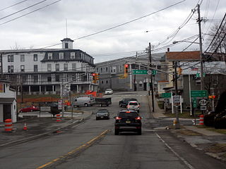
Hightstown is a borough in Mercer County, in the U.S. state of New Jersey. Nestled within the Raritan Valley region, Hightstown is an historic, commercial, and cultural hub of Central New Jersey, along with being a diverse outer-ring commuter suburb of New York City in the New York Metropolitan Area. As of the 2020 United States census, the borough's population was 5,900, its highest decennial count ever and an increase of 406 (+7.4%) from the 5,494 recorded at the 2010 census, which in turn reflected an increase of 278 (+5.3%) from the 5,216 counted in the 2000 census.

<span class="mw-page-title-main">Hopewell, New Jersey</span> Borough in Mercer County, New Jersey, US

Hopewell is a borough in Mercer County, in the U.S. state of New Jersey. Centrally located within the Raritan Valley region, this historical settlement is an exurban commuter suburb of New York City in the New York metropolitan area as defined by the United States Census Bureau. As of the 2020 United States census, the borough's population was 1,918, a decrease of 4 (−0.2%) from the 2010 census count of 1,922, which in turn had reflected a decline of 113 (−5.6%) from the 2,035 counted in the 2000 census.

<span class="mw-page-title-main">Hopewell Township, Mercer County, New Jersey</span> Township in Mercer County, New Jersey, US

Hopewell Township is a township in Mercer County, in the U.S. state of New Jersey. Located at the cross-roads between the Delaware Valley region to the southwest and the Raritan Valley region to the northeast, the township considered an exurb of New York City in the New York metropolitan area as defined by the United States Census Bureau, while also directly bordering the Philadelphia metropolitan area, being a part of the Federal Communications Commission's Philadelphia Designated Market Area. As of the 2020 United States census, the township's population was 17,491, its highest decennial count ever and an increase of 187 (+1.1%) from the 2010 census count of 17,304, which in turn reflected an increase of 1,199 (+7.4%) from the 16,105 counted in the 2000 census.

<span class="mw-page-title-main">Lawrence Township, Mercer County, New Jersey</span> Township in Mercer County, New Jersey, US

Lawrence Township is a township in Mercer County, in the U.S. state of New Jersey. Located at the cross-roads between the Delaware Valley region to the southwest and the Raritan Valley region to the northeast, the township is an outer-ring suburb of New York City in the New York Metropolitan area, as defined by the United States Census Bureau, while also directly bordering the Philadelphia metropolitan area and is part of the Federal Communications Commission's Philadelphia Designated Market Area.

<span class="mw-page-title-main">Pennington, New Jersey</span> Borough in Mercer County, New Jersey, US

Pennington is a borough in Mercer County, in the U.S. state of New Jersey. The borough is located at the cross-roads between the Delaware Valley region to the southwest and the Raritan Valley region to the northeast. As of the 2020 United States census, the borough's population was 2,802, its highest decennial count ever and an increase of 217 (+8.4%) from the 2010 census count of 2,585, which in turn had reflected a decline of 111 (−4.1%) from the 2,696 counted in the 2000 census.

<span class="mw-page-title-main">Robbinsville Township, New Jersey</span> Township in Mercer County, New Jersey, US

Robbinsville Township is a township in Mercer County, in the U.S. state of New Jersey. Located at the cross-roads between the Delaware Valley region to the southwest and the Raritan Valley region to the northeast, the township is considered part of the New York Metropolitan area as defined by the United States Census Bureau, but directly borders the Philadelphia metropolitan area and is part of the Federal Communications Commission's Philadelphia Designated Market Area. As of the 2020 United States census, the township's population was 15,476, its highest decennial count ever and an increase of 1,834 (+13.4%) from the 13,642 recorded at the 2010 census, which in turn reflected an increase of 3,367 (+32.8%) from the 10,275 counted in the 2000 census. The township is named for George R. Robbins, who served in the United States House of Representatives from 1855 to 1859 and lived in the area. Inspired by its central geographical location within New Jersey, Robbinsville's motto is Be at the Center of it All.

<span class="mw-page-title-main">West Windsor, New Jersey</span> Township in Mercer County, New Jersey, US

West Windsor is a township in Mercer County, in the U.S. state of New Jersey. Located at the cross-roads between the Delaware Valley region to the southwest and the Raritan Valley region to the northeast, the township is considered to be an outer-ring suburb of New York City in the New York metropolitan area, as defined by the United States Census Bureau. As of the 2020 United States census, the township's population was 29,518, its highest decennial count ever and an increase of 2,353 (+8.7%) from the 27,165 recorded at the 2010 census, which in turn reflected an increase of 5,258 (+24.0%) from the 21,907 counted in the 2000 census.

<span class="mw-page-title-main">Allentown, New Jersey</span> Borough in Monmouth County, New Jersey, US

Allentown is a borough located in western Monmouth County, in the U.S. state of New Jersey, bordering adjacent Mercer County. As of the 2020 United States census, the borough's population was 1,734, a decrease of 94 (−5.1%) from the 2010 census count of 1,828, which in turn reflected a decline of 54 (−2.9%) from the 1,882 counted in the 2000 census. The borough is nestled within central New Jersey, and is roughly equidistant between New York City and Philadelphia.

<span class="mw-page-title-main">Millstone, New Jersey</span> Borough in Somerset County, New Jersey, United States

Millstone is a borough in Somerset County, in the U.S. state of New Jersey. The borough was originally known as Somerset Courthouse and was the county seat. As of the 2020 United States census, the borough's population was 448, an increase of 30 (+7.2%) from the 2010 census count of 418, which in turn reflected an increase of 8 (+2.0%) from the 410 counted in the 2000 census.

<span class="mw-page-title-main">Rocky Hill, New Jersey</span> Borough in Somerset County, New Jersey, US

Rocky Hill is a borough in Somerset County, in the U.S. state of New Jersey. Named for the Rocky Hill Ridge, this historic village is nestled within the heart of the Raritan Valley region, located alongside the course of the Millstone River.

<span class="mw-page-title-main">Washington Township, Warren County, New Jersey</span> Township in Warren County, New Jersey, US

Washington Township is a township in Warren County, in the U.S. state of New Jersey. As of the 2020 United States census, the township's population was 6,492, a decrease of 159 (−2.4%) from the 2010 census count of 6,651, which in turn reflected an increase of 403 (+6.5%) from the 6,248 counted in the 2000 census.

<span class="mw-page-title-main">Borough of Princeton, New Jersey</span> Populated place in Mercer County, New Jersey, US

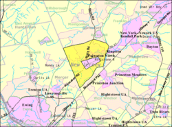
The Borough of Princeton was a borough of New Jersey that existed from 1813 until the end of 2012. On January 1, 2013, it merged with Princeton Township to form Princeton, New Jersey; both the Borough of Princeton and Princeton Township were dissolved in the merger.

References

  1. 1 2 2012 New Jersey Legislative District Data Book, Rutgers University Edward J. Bloustein School of Planning and Public Policy, March 2013, p. 103.
  2. 1 2 Elected Officials Archived 2013-05-11 at the Wayback Machine , p. 14. Mercer County, New Jersey, Revised January 26, 2012. Accessed November 20, 2012.
  3. 2012 New Jersey Mayors Directory, New Jersey Department of Community Affairs, August 9, 2012. Accessed November 20, 2012. As of the date accessed, a term-end year of 2011 is listed for Chad Goerner.
  4. 1 2 Administration [ permanent dead link ], Princeton Township. Accessed August 20, 2012.
  5. Office of the Township Clerk [ permanent dead link ], Princeton Township. Accessed August 20, 2012.
  6. 1 2 3 4 5 Gazetteer of New Jersey Places, United States Census Bureau. Accessed October 23, 2012.
  7. U.S. Geological Survey Geographic Names Information System: Township of Princeton, Geographic Names Information System. Accessed August 20, 2012.
  8. 1 2 3 4 5 6 DP-1 - Profile of General Population and Housing Characteristics: 2010 for Princeton township, Mercer County, New Jersey Archived 2020-02-12 at archive.today , United States Census Bureau. Accessed August 20, 2012.
  9. 1 2 3 Profile of General Demographic Characteristics: 2010 for Princeton township Archived 2013-07-23 at the Wayback Machine , New Jersey Department of Labor and Workforce Development. Accessed August 20, 2012.
  10. Look Up a ZIP Code for Princeton, NJ, United States Postal Service. Accessed August 20, 2012.
  11. 1 2 U.S. Census website, United States Census Bureau. Accessed September 4, 2014.
  12. Geographic codes for New Jersey, Missouri Census Data Center. Accessed August 20, 2012.
  13. US Board on Geographic Names, United States Geological Survey. Accessed September 4, 2014.
  14. Table 7. Population for the Counties and Municipalities in New Jersey: 1990, 2000 and 2010 Archived 2017-08-07 at the Wayback Machine , New Jersey Department of Labor and Workforce Development, February 2011. Accessed August 20, 2012.
  15. Snyder, John P. The Story of New Jersey's Civil Boundaries: 1606-1968, Bureau of Geology and Topography; Trenton, New Jersey; 1969. p. 164. Accessed August 24, 2012.
  16. 1 2 Clerkin, Bridget (November 8, 2011). "Princeton voters approve consolidation of borough, township into one municipality". The Times . Trenton, NJ. Retrieved November 9, 2011.
  17. Halbfinger, David M. "Governors Don’t Call This Home", The New York Times , November 19, 2009. Accessed August 20, 2012. "It is a 20-room Greek Revival mansion, with Italian gardens, a music room and a wood-paneled library. But no one seems to want to live in Drumthwacket, the governor’s residence in Princeton Township, N.J."
  18. US Gazetteer files: 2010, 2000, and 1990, United States Census Bureau. Accessed September 4, 2014.
  19. New Jersey: 2010 - Population and Housing Unit Counts - 2010 Census of Population and Housing (CPH-2-32), P. III-4. United States Census Bureau, August 2012. Accessed December 21, 2014. "Deleted CDPs: Ewing (was coextensive with Ewing township); Mercerville-Hamilton Square (split to form all of Mercerville and part of Hamilton Square CDPs); Princeton North; and Yardville-Groveville (split to form parts of Groveville and Yardville CDPs)."
  20. Census Estimates for New Jersey April 1, 2010 to July 1, 2011, United States Census Bureau. Accessed November 20, 2012.
  21. Staff. A compendium of the ninth census, 1870, p. 260. United States Census Bureau, 1872. Accessed November 20, 2012. Population of 3,986 was shown for township, including 2,798 in the borough, with the total shown calculated via subtraction.
  22. Porter, Robert Percival. Preliminary Results as Contained in the Eleventh Census Bulletins: Volume III - 51 to 75, p. 98. United States Census Bureau, 1890. Accessed November 20, 2012. Population of 4,348 in 1880 and 4,231 in 1890 shown for township, including 3,209 in 1880 and 3,422 in 1890 for the borough, with the totals shown calculated via subtraction.
  23. Thirteenth Census of the United States, 1910: Population by Counties and Minor Civil Divisions, 1910, 1900, 1890, United States Census Bureau, p. 337. Accessed November 20, 2012.
  24. Fifteenth Census of the United States : 1930 - Population Volume I, United States Census Bureau, p. 716. Accessed November 20, 2012.
  25. Table 6. New Jersey Resident Population by Municipality: 1930 - 1990 Archived 2015-05-10 at the Wayback Machine , New Jersey Department of Labor and Workforce Development. Accessed June 28, 2015.
  26. 1 2 3 4 5 Census 2000 Profiles of Demographic / Social / Economic / Housing Characteristics for Princeton township, New Jersey Archived 2004-01-14 at the Wayback Machine , United States Census Bureau. Accessed October 31, 2016.
  27. 1 2 3 4 5 DP-1: Profile of General Demographic Characteristics: 2000 - Census 2000 Summary File 1 (SF 1) 100-Percent Data for Princeton township, Mercer County, New Jersey Archived 2020-02-12 at archive.today , United States Census Bureau. Accessed August 20, 2012.
  28. DP03: Selected Economic Characteristics from the 2006-2010 American Community Survey 5-Year Estimates for Princeton township, Mercer County, New Jersey Archived 2020-02-12 at archive.today , United States Census Bureau. Accessed August 20, 2012.
  29. Money Income (1989 and 1999) and Poverty (1999) New Jersey, Counties and Municipalities, New Jersey State Data Center, April 2003. Accessed August 20, 2012.
  30. "PRISM" . Retrieved June 29, 2023.
  31. "NOHRSC" . Retrieved June 29, 2023.
  32. U.S. Potential Natural Vegetation, Original Kuchler Types, v2.0 (Spatially Adjusted to Correct Geometric Distortions), Data Basin, Accessed November 26, 2019.
  33. 1 2 Princeton Governing Body [ permanent dead link ], Princeton Township. Accessed August 20, 2012.
  34. "2 Princetons vote to merge into 1 town". Asbury Park Press . Asbury Park, NJ. Associated Press. November 8, 2011. Retrieved November 10, 2011.[ permanent dead link ]
  35. 1 2 2011 New Jersey Citizen’s Guide to Government Archived 2013-06-04 at the Wayback Machine , p. 63, New Jersey League of Women Voters. Accessed August 20, 2012.
  36. Municipalities Grouped by 2011-2020 Legislative Districts Archived 2019-06-04 at the Wayback Machine , New Jersey Department of State, p. 8. Accessed August 20, 2012.
  37. Districts by Number for 2011-2020 Archived 2019-07-14 at the Wayback Machine , New Jersey Legislature. Accessed August 20, 2012.
  38. Directory of Representatives: New Jersey, United States House of Representatives. Accessed January 3, 2019.
  39. Biography, Congresswoman Bonnie Watson Coleman. Accessed January 3, 2019. "Watson Coleman and her husband William reside in Ewing Township and are blessed to have three sons; William, Troy, and Jared and three grandchildren; William, Kamryn and Ashanee."
  40. U.S. Sen. Cory Booker cruises past Republican challenger Rik Mehta in New Jersey, PhillyVoice. Accessed April 30, 2021. "He now owns a home and lives in Newark's Central Ward community."
  41. Biography of Bob Menendez, United States Senate, January 26, 2015. "Menendez, who started his political career in Union City, moved in September from Paramus to one of Harrison's new apartment buildings near the town's PATH station.."
  42. Home, sweet home: Bob Menendez back in Hudson County. nj.com. Accessed April 30, 2021. "Booker, Cory A. - (D - NJ) Class II; Menendez, Robert - (D - NJ) Class I"
  43. Legislative Roster for District 16, New Jersey Legislature. Accessed January 18, 2024.
  44. Government, Mercer County. Accessed March 1, 2023. "Mercer County is governed by an elected County Executive and a seven-member Freeholder Board."
  45. Meet the County Executive, Mercer County. Accessed March 1, 2023. "Brian M. Hughes continues to build upon a family legacy of public service as the fourth person to serve as Mercer County Executive. The voters have reaffirmed their support for Brian's leadership by re-electing him three times since they first placed him in office in November 2003."
  46. Lucylle R. S. Walter, Mercer County. Accessed March 1, 2023.
  47. John A. Cimino, Mercer County. Accessed March 1, 2023.
  48. Samuel T. Frisby Sr., Mercer County. Accessed March 1, 2023.
  49. Cathleen M. Lewis, Mercer County. Accessed March 1, 2023.
  50. Kristin L. McLaughlin, Mercer County. Accessed March 1, 2023.
  51. Nina D. Melker, Mercer County. Accessed March 1, 2023.
  52. Terrance Stokes, Mercer County. Accessed March 1, 2023.
  53. Meet the Commissioners, Mercer County. Accessed March 1, 2023.
  54. 2022 County Data Sheet, Mercer County. Accessed March 1, 2023.
  55. Meet the Clerk, Mercer County. Accessed March 1, 2023.
  56. Members List: Clerks, Constitutional Officers Association of New Jersey. Accessed March 1, 2023.
  57. Meet the Sheriff, Mercer County. Accessed March 1, 2023.
  58. Members List: Sheriffs, Constitutional Officers Association of New Jersey. Accessed March 1, 2023.
  59. Meet the Surrogate, Mercer County. Accessed March 1, 2023.
  60. Members List: Surrogates, Constitutional Officers Association of New Jersey. Accessed March 1, 2023.
  61. Elected Officials for Mercer County, Mercer County. Accessed March 1, 2023.
  62. Voter Registration Summary - Mercer, New Jersey Department of State Division of Elections, March 23, 2011. Accessed November 21, 2012.
  63. 2008 Presidential General Election Results: Mercer County, New Jersey Department of State Division of Elections, December 23, 2008. Accessed November 21, 2012.
  64. 2004 Presidential Election: Mercer County, New Jersey Department of State Division of Elections, December 13, 2004. Accessed November 21, 2012.
  65. 2009 Governor: Mercer County Archived 2012-08-22 at the Wayback Machine , New Jersey Department of State Division of Elections, December 31, 2009. Accessed November 21, 2012.
  66. Princeton Regional Schools 2011 Report Card Narrative, New Jersey Department of Education. Accessed November 20, 2012. "As we strive each hour to serve approximately 3500 pupils from Princeton Township, Princeton Borough and Cranbury Township well, we do so knowing that the work in our classrooms, on our courts, fields and stages and in our offices matters deeply in the individual lives of each child."
  67. Data for the Princeton Regional Schools, National Center for Education Statistics. Accessed November 20, 2012.
  68. New Jersey School Directory Listings for the Princeton Regional Schools, New Jersey Department of Education. Accessed February 1, 2024.
  69. History and Mission, Princeton Charter School. Accessed November 20, 2012.
  70. Admissions, Princeton Charter School. Accessed November 20, 2012.
  71. Princeton Township - Mercer Oak [ permanent dead link ]
  72. Princeton-Pettoranello Sister City Foundation. Accessed November 24, 2011.