Limbang Division

Last updated

Limbang
Flag of Sarawak.svg
Sarawaklimbang.PNG
Division Office locationLimbang
Local area government(s) Majlis Daerah Limbang (MDLimbang)
Majlis Daerah Lawas (MDLawas)
Area
  Total7,788.5 km2 (3,007.2 sq mi)
Population
 (2000)
  Total81,152
  Density10/km2 (27/sq mi)
ResidentHaji Sebi Bin Haji Abang
EthnicityDayak Ulu (38.2%), Malay (28.5%), Iban (16.3%), Chinese (11.0%), Others (5.5%)

Limbang Division is one of the twelve administrative divisions of Sarawak, Malaysia. It has a total area of 7,788.50 square kilometres, and is the fourth largest division after Kapit Division, Miri Division and Bintulu Division. Limbang Division consists of two districts which are Limbang District and Lawas District, which in turn are divided as sub-districts in Limbang (Nanga Medamit Sub-District) and two sub-districts in Lawas (Sundar Sub-District and Trusan Sub-District). Long Semadoh and Ba’kelalan are rural settlements in the southern part of Lawas district. Two major towns in Limbang are Limbang and Lawas. There are also few smaller towns such as Sundar, Trusan, Merapok and Tedungan.

Contents

Geography

Limbang Division splits Brunei Darussalam into two; West Brunei to the west and Temburong District in the middle of Limbang and Lawas districts. Limbang is located between West Brunei and Temburong, while Lawas is located between Temburong and the Malaysian state of Sabah. This geographical situation, as well as the autonomy of Sabah and Sarawak in immigration affairs means that immigration checks are required when travelling into or out of Limbang Division by road.

Demography

As of 2002, the population of Limbang Division was 81,152. This makes Limbang one of the most sparsely populated divisions in Sarawak with only 10.5 people per square kilometre. Most of the Limbang Division population is concentrated in the coastal areas of Limbang and Lawas.

Ethnics

Limbang is traditionally a home to Bisaya,Malay, Lun Bawang, Kedayan, Kelabit, Iban, Murut/Lun Bawang, Chinese and Orang Ulu people. Other Sarawakian ethnic groups do exist, especially Bidayuh and Melanau, who migrate from various parts of Sarawak. It has one of the highest concentration of Orang Ulu and Kedayan people. Due to being so close to Brunei, the Malay dialect in Limbang Division is somehow distinct to other parts of Sarawak. It has more Kedayan, Brunei Malay and Sabah regional dialect influences to it.

Population of Limbang by Ethnics [1] [2]
Administrative DistrictTotal
Population
Malay1IbanBidayuhMelanauOther
Bumiputera2
ChineseOther
Non-Bumiputera
Non-Citizen
Limbang47,000
(54.3%)
11,700
(24.9%)
13,000
(27.7%)
300
(0.6%)
300
(0.6%)
14,000
(29.8%)
6,400
(13.6%)
200
(0.1%)
1,100
(2.3%)
Lawas39,600
(45.7%)
13,000
(32.8%)
1,100
(2.8%)
200
(0.5%)
200
(0.5%)
19,100
(48.2%)
3,100
(7.8%)
600
(1.5%)
2,600
(6.6%)
Total Limbang Division86,600
(100%)
24,700
(28.5%)
14,100
(16.3%)
500
(0.6%)
500
(0.6%)
33,100
(38.2%)
9,500
(11.0%)
800
(0.9%)
3,700
(4.3%)

Note:
1 Excluding Kedayan.
2 Including Kedayan and Orang Ulu ethnics such as Lun Bawang, Murut, Kelabit and Penan.

Members of Parliament

ParliamentMember of ParliamentParty
P221 Limbang YB Datuk Hasbi Habibollah GPS (PBB)
P222 Lawas YB Dato Henry Sum Agong GPS (PBB)

Economy

Limbang mostly relies on its agriculture, timber industry and tourism sector to keep growing. Commercial sector is thriving in Limbang because of its location is within Brunei vicinity. Limbang has one of the highest number of tourist in Sarawak whereby Bruneian and Sabahan as the main contributor.

Main commercial areas in Limbang are:

Transportation

Road

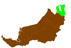
Owing to its geographical location, Limbang is completely cut off from the rest of Sarawak's road network. It is however has good road links to both parts of Brunei located to the east and west of the district. There is also a good local network of roads in the district.

There are two road border crossing checkpoints in Limbang district, both into Brunei.

Lawas, however, by virtue of its geographical location, is also cut off from the rest of Sarawak's road network. It is however linked by main road to Sabah and Brunei's Temburong district. There is a good local road network around Lawas district which is relatively free of traffic jams.

Two road border crossings are located in Lawas district.

Here are images of passport stamps from the ICQS checkpoints located in Limbang Division.

Although Limbang is well connected to other parts of Sarawak with good networks of road through Brunei, river transports still play the vital role in Limbang. People of Limbang Division can opt for rural shuttle bus service to Ng. Medamit and Tedungan from Limbang town, and also Sundar and Trusan from Lawas town.

There are some rural areas which are accessible by timber tracks and palm estate roads such as Long Tengom, Long Sukang, Merarap, Long Semado, Rutoh and Ba'Kelalan. Availability of transports to these areas are limited through bookings at Limbang and Lawas town, using private vans or four-wheel drive vehicles.

Air

There are existing small airports that served the division through MASwings namely Limbang Airport in Limbang to Kota Kinabalu, Kuching, Lawas and Miri.

Infrastructure

Education

Limbang Division has a moderate number of public schools. There are numbers of secondary school for both districts of Limbang and Lawas. As for primary schools, most of them are scattered throughout Limbang. Some of them are located deep in the Limbang Division's interior to cater for rural students. There is one Islamic secondary school which is SMKA Limbang.

There is no public or private higher institution in Limbang Division.

Healthcare

Limbang Division has two government hospital which are Limbang Hospital (located 500m from the Limbang town) and Lawas Hospital. As for Ng. Medamit, Sundar and Trusan sub-district, all has their own health clinic. Smaller government health clinics do exist at various communal areas such as Ba'Kelalan.

Security

Limbang Division has two police district offices, namely at Limbang and Lawas. There are also police stations and police bits located at strategic locations, as well as rural areas. Despite being the fourth largest division, Limbang Division so far has no district military bases. Only small military camps do exist just to make presence.

Government services

Other government offices have set up their branches in both Limbang and Lawas districts (some at Ng. Medamit, Sundar and Trusan sub-districts and other smaller communal areas) such as Royal Customs, Fire and Rescue Department, Education Department, etc.

See also

Related Research Articles

<span class="mw-page-title-main">Limbang</span> Town and district capital in Sarawak, Malaysia

Limbang is a border town and the capital of Limbang District in the Limbang Division of northern Sarawak, East Malaysia, on the island of Borneo. This district area is 3,978.10 square kilometres, and population was 56,900. It is located on the banks of the Limbang River, between the two halves of Brunei.

<span class="mw-page-title-main">Lawas</span> Town and district capital in Sarawak, Malaysia

Lawas is a small town and the capital of Lawas District, Limbang Division, Sarawak, Malaysia. This district area is 3,811.90 square kilometres, and population was 46,200. It is 1,200 km from the state capital, Kuching and 200 km from the capital city of Sabah, Kota Kinabalu.

<span class="mw-page-title-main">Sipitang</span> Town and district capital in Sabah, Malaysia

Sipitang is the capital of the Sipitang District in the Interior Division of Sabah, Malaysia. Its population was estimated to be around 4,298 in 2010. It is the closest town in Sabah to the Sarawak border, and is 44 kilometres south of Beaufort and 144 kilometres south of Kota Kinabalu, the state capital and also is 123 kilometres north of Long Pasia, one of the famous attraction in Sabah.

<span class="mw-page-title-main">Kedayan</span> Ethnic group in Borneo

The Kedayan are an ethnic group residing in Brunei, Federal Territory of Labuan, southwest of Sabah, and north of Sarawak on the island of Borneo. According to the Language and Literature Bureau of Brunei, the Kedayan language is spoken by about 30,000 people in Brunei, and it has been claimed that there are a further 46,500 speakers in Sabah and 37,000 in Sarawak. In Sabah, the Kedayan mainly live in the southern districts of Sipitang and Beaufort, where they are counted as a part of the local Malay populace. Whilst in Sarawak, the Kedayans mostly reside in the towns of Lawas, Limbang and Miri.

<span class="mw-page-title-main">Bintulu Division</span> Division of Sarawak

Bintulu Division is one of the twelve administrative divisions of Sarawak, Malaysia. It has a total area of 12,166.2 square kilometres, and is the third largest division after Kapit Division and Miri Division. Bintulu Division consists of two districts which is Bintulu and Tatau, together with a sub-district under Bintulu, which is Sebauh. Three major towns in Bintulu are Bintulu, Tatau and Sebauh.

<span class="mw-page-title-main">Malaysian Federal Roads System</span> Main national road network in Malaysia

Malaysian Federal Roads System, is the main national road network in Malaysia. All Federal Roads in Malaysia are under the purview of the Ministry of Works (MOW). According to the Ministerial Functions Act 1969, the MOW is responsible to plan, build and maintain all Federal Roads gazetted under the Federal Roads Act 1959. However, most of the Federal roads' projects were built and maintained by the Malaysian Public Works Department (JKR), which is also one of the implementing agencies under the MOW.

<span class="mw-page-title-main">Ba'kelalan</span> Town in Sarawak, Malaysia

Ba'kelalan is a group of nine villages at Maligan Highlands of Limbang Division, Sarawak, Malaysia about 3,000 feet (910 m) above sea level and 4 km from the border with Indonesian Kalimantan and 150 km from the nearest town of Lawas. There are nine villages in Ba'kelalan. The villagers here belong to the Lun Bawang tribe.

<span class="mw-page-title-main">Sindumin</span> Place in Sabah, Malaysia

Sindumin is a town located in the district of Sipitang in Sabah, Malaysia. The town was previously known as "Mengalong" in the 1960s. It is situated on the Sabah-Sarawak border in the Interior Division of Sabah along the Mengalong river. It is also one of the towns within the Brunei Bay. There are Kedayan, Murut, and Lundayeh /Lun Bawang.

<span class="mw-page-title-main">Sungai Tujoh</span> Border checkpoint between Brunei and Malaysia

Sungai Tujoh, is the westernmost point of Brunei. It is located in the Belait district.

<span class="mw-page-title-main">Lun Bawang</span>

The Lun Bawang is an ethnic group found in Central Northern Borneo. They are indigenous to the southwest of Sabah and the northern region of Sarawak, highlands of North Kalimantan and Brunei.

<span class="mw-page-title-main">Mukim Bangar</span> Mukim of Brunei

Mukim Bangar is a mukim in Temburong District, Brunei. It has a total area of 113 square kilometres (44 sq mi); the population was 2,112 in 2021. The mukim encompasses Bangar, the district's sole town and administrative centre.

<span class="mw-page-title-main">Mukim Labu</span> Mukim of Brunei

Mukim Labu is a mukim in Temburong District, Brunei. It has an area of 292 square kilometres (113 sq mi); the population was 508 in 2021.

<span class="mw-page-title-main">Brunei–Malaysia border</span> International border

The Brunei–Malaysia border divides the territory of Brunei and Malaysia on the island of Borneo. It consists of a 266 km (165 mi) land border and substantial lengths of maritime borders stretching from the coastline of the two countries to the edge of the continental shelf in the South China Sea.

<span class="mw-page-title-main">Pandaruan River</span> River in Brunei and Malaysia

The Pandaruan River is a river that forms an international border on the island of Borneo, between Temburong, Brunei and Limbang, Malaysia. It is located at the river mouth of the Brunei Bay.

<span class="mw-page-title-main">Limbang District</span> District in Sarawak, Malaysia

The Limbang District is one of the two districts of Limbang Division, Malaysia. It has a total area of 3,978.10 square kilometres. The major town is Limbang. It has one sub-district, which is Nanga Medamit Sub-District. It borders Brunei Darussalam to the west and east, Lawas District to the southeast and Miri District at the south and southwest. Due to being squeezed in between Brunei at its north and coastal areas, Limbang is accessible by road only by going through immigration posts.

<span class="mw-page-title-main">Kampong Kuala Lurah</span> Village in Brunei-Muara, Brunei

Kampong Kuala Lurah is a village in the south-west of Brunei-Muara District, Brunei, immediately adjacent to the Brunei-Malaysia border. The population was 798 in 2016. It serves as the vehicular entry point to mainland part of the country from Limbang District in the Malaysian state of Sarawak. It is one of the villages within Mukim Pengkalan Batu. The postcode is BH1923.

The Sarawak section of the Federal Route 1, Asian Highway Route AH 150, also known as Pan Borneo Highway Sarawak or Sarawak First Trunk Road, is a 1077-km federal highway in Sarawak, Malaysia, making the highway as the longest component of the Malaysian portion of the larger Pan Borneo Highway network. Construction of the highway began in 1965 after Sarawak became a member of the federation of Malaysia in 1963.

<span class="mw-page-title-main">Ulu Temburong National Park</span> National park in Brunei

Ulu Temburong National Park is the first national park to be established in Brunei, protected since 1991. The park is in Temburong District in eastern Brunei, and covers about 40% of the district in the south at 550 square kilometres (210 sq mi). It is within the Batu Apoi Forest Reserve. The park contains unspoiled jungle and is known as the "Green Jewel of Brunei", described as "the finest example of the sultanate's successful forest protection policy". The principal rivers are the Temburong and Belalong Rivers. It is an important ecotourism centre in Brunei and hosts the Ulu Ulu Resort. The Peradayan Forest Reserve is also located in the district.

<span class="mw-page-title-main">Lawas District</span> Place in Malaysia

The Lawas District is one of the two districts of Limbang Division, Malaysia. The major town is Lawas.

<span class="mw-page-title-main">Sipitang District</span> District in Sabah, Malaysia

The Sipitang District is an administrative district in the Malaysian state of Sabah, part of the Interior Division which also includes the districts of Beaufort, Keningau, Kuala Penyu, Nabawan, Tambunan and Tenom. The capital of the district is in Sipitang Town. The ecotourism village of Long Mio and Long Pasia is located in this district, while the small town of Sindumin serves as a gateway to the state of Sarawak.

References

  1. Sarawak Ethnic Statistic from Sarawak Journal.
  2. Sarawak Ethnic Statistic from Sarawak Journal.