
The Rajang River is a river in Sarawak, Malaysia. The river is located in northwest of Borneo. The river originates in the Iran Mountains, flows through Kapit, and then towards the South China Sea. At approximately 565 km long (351 mi) of total length, it is the 4th longest river in Borneo, and the longest river in Malaysia.

Punan Bah or Punan is an ethnic group found in Sarawak, Malaysia and in Kalimantan, Indonesia. The Punan Bah people are distinct and unrelated to the semi-nomadic Penan people. Their name stems from two rivers along the banks of which they have been living since time immemorial. They do have other names: Mikuang Bungulan or Mikuang and Aveang Buan. But those terms are only used ritually these days.

Bintulu Division is one of the twelve administrative divisions of Sarawak, Malaysia. It has a total area of 12,166.2 square kilometres, and is the third largest division after Kapit Division and Miri Division. Bintulu Division consists of two districts which is Bintulu and Tatau, together with a sub-district under Bintulu, which is Sebauh. Three major towns in Bintulu are Bintulu, Tatau and Sebauh.
Tatau is a town, and the capital of the Tatau District in Bintulu Division, Sarawak, Malaysia. The district's reported total population for Tatau was 30,383. Tatau became a district in 1987. Before that it was a Sub District under Bintulu District. The main spoken languages are Iban, Kenyah, Beketan and Punan.

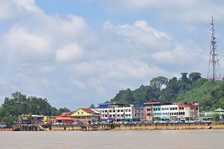
Song is a town, and the capital of the Song District in Kapit Division, Sarawak, Malaysia. The district population was 20,046 according to the 2010 census. Song is situated by the banks of the Katibas River, a tributary of the Rajang River. It is an important stopover for river traffic going up the Rajang River.
Kanowit is a town and the capital of a district of the same name, located within the Sibu Division, Sarawak, Malaysia, comprising 2,253.5 square kilometres. As of 2010, Kanowit's population is 28,985. It is built on the mouth of Kanowit River at the bank of Rajang River, approximately 174 kilometers from the coast of South China Sea. It takes 45 minutes to reach the town by land transport and an hour by boat from Sibu. The main ethnic groups are Iban, Chinese, Malay, and Melanau.

Betong Division, formed on 26 March 2002, is one of the twelve administrative divisions in Sarawak, Malaysia. Formerly part of Sri Aman Division, Betong is in the Saribas area. It has a total area of 4,180.8 square kilometres, and is the smallest of the administrative divisions of Sarawak.

Mukah Division is one of the twelve administrative divisions in Sarawak, Malaysia. It was established on 1 March 2002 and it has a total area of 6,997.61 square kilometres.

Melanau or A-Likou is an ethnic group indigenous to Sarawak, Malaysia. They are among the earliest settlers of Sarawak. They speak in the Melanau language, which is a part of the North Bornean branch of Malayo-Polynesian languages.

Limbang Division is one of the twelve administrative divisions of Sarawak, Malaysia. It has a total area of 7,788.50 square kilometres, and is the fourth largest division after Kapit Division, Miri Division and Bintulu Division. Limbang Division consists of two districts which are Limbang District and Lawas District, which in turn are divided as sub-districts in Limbang and two sub-districts in Lawas. Long Semadoh and Ba’kelalan are rural settlements in the southern part of Lawas district. Two major towns in Limbang are Limbang and Lawas. There are also few smaller towns such as Sundar, Trusan, Merapok and Tedungan.

Bintulu is a coastal town on the island of Borneo in the central region of Sarawak, Malaysia. Bintulu is located 610 kilometres (380 mi) northeast of Kuching, 216 kilometres (134 mi) northeast of Sibu, and 200 kilometres (120 mi) southwest of Miri. With a population of 114,058 as of 2010, Bintulu is the capital of the Bintulu District of the Bintulu Division of Sarawak, Malaysia.

Tatau District is one of the two districts of Bintulu Division in Sarawak, Malaysia. It has a total area of 4,945.80 square kilometres. The largest town in the district is Tatau.

The Bintulu District is one of two districts of Bintulu Division in Sarawak, Malaysia. It has a total area of 7,220.40 square kilometres. Bintulu District has a sub-district, which is Sebauh. There are two towns in Bintulu District, namely Bintulu, which is the capital of both Bintulu District and Bintulu Division, and Sebauh.

The Limbang District is one of the two districts of Limbang Division, Malaysia. It has a total area of 3,976.00 square kilometres. The major town is Limbang. It has one sub-district, which is Nanga Medamit Sub-District. It borders Brunei Darussalam to the west and east, Lawas District to the southeast and Miri District at the south and southwest. Due to being squeezed in between Brunei at its north and coastal areas, Limbang is accessible by road only by going through immigration posts.

Balingian also known as Kuala Balingian is a town in Sarawak, Malaysia. It lies approximately 286.1 kilometres (178 mi) east-north-east of the state capital Kuching.

Selangau, Sarawak, is a small town located by the Pan Borneo Highway. It is also located by Batang Mukah, a river which flows to the South China Sea. It is located approximately 74 km (46 mi) from Sibu city, 84 km (52 mi) from Mukah town and 134 km (83 mi) from Bintulu town. Selangau town is the administrative centre for the Selangau District.
Sarawak's population is very diverse, comprising many races and ethnic groups. Sarawak has more than 40 sub-ethnic groups, each with its own distinct language, culture and lifestyle. This makes Sarawak demography very distinct and unique compared to its Peninsular counterpart.
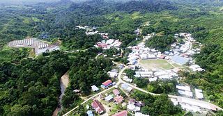
Data Kakus is a remote Kenyah Badeng village settlement in the hilly interior of the Ulu Kakus Tatau division of Sarawak, Malaysia elevates to 650 metres, not far from Tubau and Belaga district. To be exact, Data Kakus is located at the upstream of Sungai Burok and Sungai Nyabet. The highest peak in Ulu Kakus is called Gunung Lumut about 828m located on the peak of Lumut Range not too far from Sungai Bekuyat and Sungai Kakus.
Mukah (muːkəh), formerly known as Muka is a coastal town which serves as the capital and the administrative center of the Mukah Division since 1 March 2002.
Kampung Senap is a remote Kenyah Badeng village settlement in the hilly interior of the Hulu Selangor District, Tinggang, Tubau, Sebauh, Bintulu division of Sarawak, Malaysia, elevates to 620 metres, not far from Tubau and Sebauh Sub-district. Kampung Senep is located at the upstream of Sungai Tinggang and Sungai Senep. The highest peak in Ulu Senep is called Gunung Lumut about 828 m located on the peak of Lumut Range not too far from Sungai Bekuyat and Sungai Kakus.


