Kabong | |
|---|---|
 | |
| Country | |
| State | |
| Area | |
• Total | 799 km2 (308 sq mi) |
| Population (2020) | |
• Total | 11,700 |
| • Density | 15/km2 (38/sq mi) |

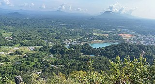
Kabong is a district, in Betong Division, Sarawak, Malaysia. [1] [2]
Kabong | |
|---|---|
| | |
| Country | |
| State | |
| Area | |
• Total | 799 km2 (308 sq mi) |
| Population (2020) | |
• Total | 11,700 |
| • Density | 15/km2 (38/sq mi) |
Kabong is a district, in Betong Division, Sarawak, Malaysia. [1] [2]
Total population of every areas in Kabong, Sarawak. These population are exactly based on their ethnics in Sarawak.
Kabong is the only district that predominantly Sarawak Malay community, especially in Kabong Town and Gerigat. Only Roban area is mostly are community from Iban ethnic.
TOTAL : 6,854
TOTAL : 4,082
TOTAL : 764
| Route No. | Operating Route | Operator | Remark |
|---|---|---|---|
| 24 | Sarikei-Kabong | Borneo Bus | |
The United Bumiputera Heritage Party is a political party in Malaysia. It is currently the largest multiracial political party in Sarawak. Parti Pesaka Bumiputera Bersatu was formed from the combination of three parties in Sarawak; Parti Negara Sarawak, Barisan Rakyat Jati Sarawak and Parti Pesaka Anak Sarawak. The formation of the party was for the purpose of the improvement of the livelihood and protect the rights of the Bumiputera in many sectors such as politics, social, sports, education, infrastructures, financial & monetary autonomy, science, and technology. Formerly as a part of Semenanjung-based coalition Barisan Nasional (BN), following the defeat of BN in the 2018 general election and in the aftermath of a meeting between all Sarawak-based BN coalition parties on 12 June 2018, PBB left the coalition to form a new Sarawak-based coalition, Sarawak Parties Alliance.

Kapit Division, formed on 2 April 1973, is one of the twelve administrative divisions in Sarawak, Malaysia. It has a total area of 38,934 km2 (15,033 sq mi), and is the largest of the administrative divisions of Sarawak.

Bintulu Division is one of the twelve administrative divisions of Sarawak, Malaysia. It has a total area of 12,166.2 km2 (4,697.4 sq mi), and is the third largest division after Kapit Division and Miri Division. Bintulu Division consists of two districts which is Bintulu and Tatau, together with a sub-district under Bintulu, which is Sebauh. Three major towns in Bintulu are Bintulu, Tatau and Sebauh.

Betong Division, formed on 26 March 2002, is one of the twelve administrative divisions in Sarawak, Malaysia. Formerly part of Sri Aman Division, Betong is in the Saribas area. It has a total area of 4,180.8 square kilometres, and is the smallest of the administrative divisions of Sarawak.

Betong is a town in Betong Division in Sarawak, Malaysia, lying in the Saribas area. It was formerly under the Sri Aman district. Betong is located between three main rivers, Batang Lupar, Batang Saribas and Batang Kelaka, and covers an area of 4,180 km2.

Samarahan Division is one of the twelve administrative divisions in Sarawak, Malaysia. Formerly part of the First Division, which included Kuching, it became a separate Division on 24 July 1986, with a total area of 4,967.4 square kilometres.

Kuching Division is one of the twelve administrative divisions in Sarawak, Malaysia. Formerly part of what was called the "First Division", it is the center and the starting point of modern Sarawak. Kuching Division has a total area of 4,559.5 km2 (1,760.4 sq mi).

Petra Jaya is a suburb of Kuching, Sarawak, Malaysia. This suburb was named after the sixth Yang di-Pertuan Agong, Tuanku Yahya Petra of Kelantan (1975-1979).

Limbang Division is one of the twelve administrative divisions of Sarawak, Malaysia. It has a total area of 7,788.50 square kilometres, and is the fourth largest division after Kapit Division, Miri Division and Bintulu Division. Limbang Division consists of two districts which are Limbang District and Lawas District, which in turn are divided as sub-districts in Limbang and two sub-districts in Lawas. Long Semadoh and Ba’kelalan are rural settlements in the southern part of Lawas district. Two major towns in Limbang are Limbang and Lawas. There are also few smaller towns such as Sundar, Trusan, Merapok and Tedungan.

Padawan is a sub-district of Kuching District, Sarawak, Malaysia. The name is also used to refer to the local government in Sarawak, the Padawan Municipal Council, and to Bidayuh Village, which is also known as Kampung Padawan. The Jalan Padawan is the name of a road near mile 23 of Kuching-Serian Highway.

The Sri Aman District is one of two districts in the Sri Aman Division of Sarawak, Malaysia. It is named after its capital Simanggang. It has a land area of 2,323.7 square kilometres.

Tatau District is one of the two districts of Bintulu Division in Sarawak, Malaysia. It has a total area of 4,945.80 square kilometres. The largest town in the district is Tatau.

Sebauh is a district of Bintulu Division, Sarawak, Malaysia. It shares a boundary with Miri, Baram, Kapit Division, Belaga and Tatau. It has a total area of roughly 5,262.90 square kilometres. Sebauh town is a main administrative and economy centre of Sebauh district.

The Bintulu District is one of two districts of Bintulu Division in Sarawak, Malaysia. It has a total area of 7,220.40 square kilometres. Bintulu District has a sub-district, which is Sebauh. There are two towns in Bintulu District, namely Bintulu, which is the capital of both Bintulu District and Bintulu Division, and Sebauh.

The sixth Sarawak state election was held between Friday, 27 September and Saturday, 28 September 1991. This election elected 56 state representatives into the Sarawak State Assembly. This election saw 72.8% of the eligible voters to cast their votes.
Sarawak's population is very diverse, comprising many races and ethnic groups. Sarawak has more than 40 sub-ethnic groups, each with its own distinct language, culture and lifestyle. This makes Sarawak demography very distinct and unique compared to its Peninsular counterpart. However, it largely mirrors to other territories in Borneo – Sabah, Brunei and Kalimantan.

Sarawakian cuisine is a regional cuisine of Malaysia. Similar to the rest of Malaysian cuisine, Sarawak food is based on staples such as rice. There is also a great variety of other ingredients and food preparations due to the influence of the state's varied geography and indigenous cultures quite distinct from the regional cuisines of the Peninsular Malaysia. Sarawak is famous for its multi-ethnic population. As the homeland of many unique communities, Sarawak has a variety of cuisines rarely found elsewhere in Malaysia. The uniqueness of Sarawak well depends on its ethnic groups. Every native group in Sarawak has their own lifestyle, traditions, cultures and also foods. Sarawak cuisine is less spicy and has a subtle in taste. It uses fresh seafood and natural herbs like turmeric, lemongrass, ginger, lime and tapioca leaves. These ingredients are not only easily available, but also add a hint of aroma, texture and freshness to the delicacies. Food is one of the most cultural identities for native groups in Sarawak with each ethnic group having their own delicacies. Among the Iban, popular foods include tubu (stems), tuak and pansuh. The Malay have bubur pedas (porridge) and kek lapis Sarawak ; the Bidayuh have asam siok and sup ponas Bidayuh. The Melanau make tebaloi, sagu and umai and the Orang Ulu are known for garam barrio, kikid (broth), tengayen, and urum giruq (pudding).

Tebedu District is a district in the state of Sarawak, Malaysia. It is a part of Serian Division that consists of Serian, Siburan, and Tebedu districts. Before this, Tebedu District was a sub-district under Serian District which was then fully upgraded to a district in its own right. The majority of the population of this district is from the Bidayuh ethnic group.
Bau is a district, in Kuching Division, Sarawak, Malaysia. Its seat is the town of Bau.

Betong is a district, in Betong Division, Sarawak, Malaysia. The city of Betong, which is the administrative centre of the larger Betong Division, is located in this district.
Capital: Kuching | |
| History | |
| Topics | |
| Society |
|
| Administrative divisions | |
1°49′42.0″N111°08′01.2″E / 1.828333°N 111.133667°E
| | This Sarawak location article is a stub. You can help Wikipedia by expanding it. |