Kanowit is a town and the capital of Kanowit District, Sibu Division, Sarawak, Malaysia, comprising 2,253.5 square kilometres. As of 2010, Kanowit's population is 28,985. It is built on the mouth of Kanowit River at the bank of Rajang River, approximately 174 kilometers from the coast of South China Sea. It takes 45 minutes to reach the town by land transport and an hour by boat from Sibu. The main ethnic groups are Iban, Chinese, Malay, and Melanau.

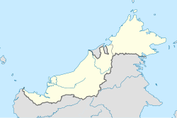
Mukah Division is one of the twelve administrative divisions in Sarawak, Malaysia. It was established on 1 March 2002 and it has a total area of 6,997.61 square kilometres.

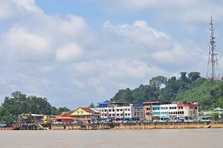
Dalat is the administrative town of the Dalat district in Mukah Division, Sarawak, Malaysia. It is situated by the Oya River.

Melanau or A-Likou is an ethnic group indigenous to Sarawak, Malaysia. They are among the earliest settlers of Sarawak. They speak the Melanau language, which is a part of the North Bornean branch of Malayo-Polynesian languages.

Setapak is a town and mukim straddling both norteastern Kuala Lumpur and Gombak District of Selangor, Malaysia.
Bruit Island is an island in Daro District, Mukah Division, Sarawak, Malaysia. It is located in the Rejang Delta, 150 km northwest of Kuching. With a population of around 9,342 and an area of 417 square kilometres, it is the second largest island in Malaysia after Banggi Island. The mudflats at the northern end of the island have been designated an Important Bird Area by BirdLife International.
Maludam, Saribas is a very small town and sub district in Betong Division, Sarawak, Malaysia. It is made up of a small town including some modern longhouses with a few Malay fishing villages nearby. The majority of people are Malays, with some Ibans and Chinese. Maludam was made a district in 1985.
Oya is a town and the administrative centre of the subdistrict of the same name in Mukah Division, in the Malaysian state of Sarawak. It is located near the mouth of Oya River with the South China Sea. Oya is about 26 kilometres to the west of Mukah, the division's administrative town.

The Roman Catholic Diocese of Sibu is the ecclesiastical territory of the Latin Church or the diocese of the Catholic Church in the state of Sarawak, Malaysia. It is headquartered in Sibu and covered the divisions of Sibu, Mukah, Sarikei, and Kapit.
Tebakang is a village in the Serian division of Sarawak, Malaysia, between Serian and Tebedu. It is about 15 minutes drive from Serian Town. Tebakang lies approximately 56.9 kilometres (35 mi) south-south-east of the state capital Kuching.

Balingian also known as Kuala Balingian is a town in Sarawak, Malaysia. It lies approximately 286.1 kilometres (178 mi) east-north-east of the state capital Kuching.
The Dalat District is located in Mukah Division, Sarawak, Malaysia. It is situated by the Oya river. The district covers areas from Kg. Penat to Oya, and from Muara Sg. Kut to Ulu Baoh. The district has an area of 905.29 km2, while the Oya sub-district has an area of 147.47 km2.
A kampong is the term for a village in Brunei, Indonesia, Malaysia and Singapore and a "dock" in Cambodia. The term applies to traditional villages, especially of the indigenous people, and has also been used to refer to urban slum areas and enclosed developments and neighborhoods within towns and cities in Brunei, Indonesia, Malaysia, Singapore, Cambodia, Sri Lanka, and Christmas Island. The design and architecture of traditional kampong villages have been targeted for reform by urbanists and modernists and have also been adapted by contemporary architects for various projects.
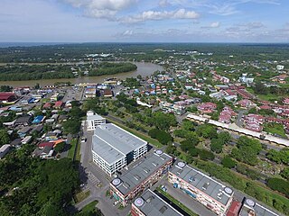
Mukah (muːkəh), historically known as Muka is a coastal town which has served as the capital and the administrative center of the Mukah Division since 1 March 2002.

Igan is a federal constituency in Mukah Division, Sarikei Division and Sibu Division, Sarawak, Malaysia, that has been represented in the Dewan Rakyat since 2008.

Kampong Bukit Udal or simply known as Bukit Udal, is a village in Tutong District, Brunei, about 11 kilometres (6.8 mi) from the district town Pekan Tutong. It has an area of 13 square kilometres ; the population was 1,306 in 2016. It is one of the villages within Mukim Tanjong Maya, a mukim in the district.
Kampong Birau is a village in the north-east of Tutong District, Brunei, about 19 kilometres (12 mi) from the district town Pekan Tutong. It has an area of 13.5 square miles (35 km2); the population was 989 in 2016. It is one of the villages within Mukim Kiudang, a mukim in the district.

Tebedu District is a district in the state of Sarawak, Malaysia. It is a part of Serian Division that consists of Serian, Siburan, and Tebedu districts. Before this, Tebedu District was a sub-district under Serian District which was then fully upgraded to a district in its own right. The majority of the population of this district is from the Bidayuh ethnic group.
Kampung Medong is a village located within Dalat District in Mukah Division, Sarawak. The village is located about 6.1 kilometres to the south of Dalat town.