Tanjung Manis District

Last updated
Tanjung Manis
CountryMalaysia
State Sarawak

Tanjung Manis is a district in Mukah Division, Sarawak, Malaysia. The capital of the district is Tanjung Manis town. [1]

Contents

History

Tanjung Manis market. Tanjung Manis market.jpg
Tanjung Manis market.

The Tanjung Manis District was originally named "Belawai sub-district" on 7 April 1973 and was placed under the administration of Sarikei Division. [2] On 1 March 2002, Belawai sub-district was placed under the administration of Mukah Division. [2] On 11 February 2008, Sarawak Corridor of Renewable Energy (SCORE) was launched. [3] The town of Tanjung Manis is designated as halal food hub [4] and Tanjung Manis Integrated Port was built here. [5] On 1 August 2015, the Belawai sub-district was concurrently upgraded into a district and renamed to Tanjung Manis District. [2]

Administration

Tanjung Manis District covers an area of 730.53 km2. [2]

Town and villages

Tanjung Manis

The town is located 82 km away from Sibu, 19.5 km from Tanjung Manis airport, and 28 km from Sarikei. [6] The government of Sarawak started to develop this area in the 1990s because of its strategic location as a protected harbour for timber processing industry. In 1994, the construction of timber processing zone (TPZ) was completed. About 1,000 houses were built in 1995. Central oil distribution terminal was completed in 2002. There were 40 shophouses as of January 2022. [7] In November 2022, 16-storey Tanjung Manis administrative centre was built. The administrative centre commence operation in 2023. [1]

Belawai

Belawai was the former administrative centre for Tanjung Manis district. [8] Based on a census in 2018, Belawai village occupies 3,730 hectares with 2,823 inhabitants. The village is also notable for its beaches and fishery industry. [9] In 2023, Tanjung Manis district office was moved from Belawai to the town of Tanjung Manis. [10] [1]

Jerijeh

Jerijeh village is located 20 km from the town of Tanjung Manis. Tanjung Manis airport is located here. [11]

Rajang

Rajang village developed its own songket weaving industry since 1991. [12]

Population

The majority of the population in the district are Melanau. [2]

Economy

Tanjung Manis District has been designated as a growth area under Sarawak Corridor of Renewable Energy (SCORE) since 2008 as aquaculture, timber-based, and marine engineering industry. As a result of this plan, Integrated Deep Sea Fishing Port, Tanjung Manis Integrated Port and Oil Gas Chemical terminal, and a wood-based industrial area were set up. [13]

Tanjung Manis anchorage existed from the 1950s to the 60s for ocean-going vessels to load and unload goods. In the 1990s, Japan International Corporation Agency recommended the Sarawak government build port facilities at the Tanjung Manis anchorage site. The project was completed in November 1997 and was put under the administration of Rajang Port Authority (RPA) in Sibu. [14] However, the port failed to attract shippers due to the absence of road access to the town of Sibu and also the 1997 Asian financial crisis. [14] In 2009, Tanjung Manis Integrated Port Sdn. Bhd (a subsidiary of Sarawak Timber Development Corporation (STIDC)), started to oversee the port operations. The port started to receive more traffic since then. [14] Since April 2012, the port administration was transferred from RPA to newly established Tanjung Manis Port Authority (TMPA). [15] Evergreen Marine Corporation, MTT Shipping and Pacific Selatan Agency are the carriers that used Tanjung Manis port as one of their shipping stops. [6] Revenue of Tanjung Manis Integrated Port stood at RM1 million in 2016. [16] Total export value of Tanjung Manis Port from January to September 2022 stood at RM1.2 billion. [17] Main export commodities in 2016 were: coal, agricultural products, woodchip, plywood, sawn timber, and logs. Main import commodities were: building materials, veneer, animal feeds, foodstuffs, hardware, and textile. [18]

The district is famous for its fishery industry, especially the catches of giant tiger prawn (known as Udang harimau locally). [2] There is also s small-scale prawn processing industry. The prawns' shells are removed and put into cold storage or made into smoked prawns to be sold later to nearby towns and cities, especially Sibu. [19]

Transportation

Water

There is a Tanjung Manis Port.

Air

There is an airport in the district named Tanjung Manis Airport. [20]

Road

Although 70% of Tanjung Manis district can be accessed by roads, 30% of the areas still requires water transport such as Paloh, Stalun, Sebayang, Sungai Berangan and Telok Gelam. The district is connected to Sibu through a network of trunk road and ferry services. [2]

Bus Route No.Operating RouteOperatorRemark
23Sibu-Tanjung Manis-BelawaiLanang Bus

Culture and leisure

Attraction and recreational spots

The Belawai beach Belawai beach near Iftitah restaurant.jpg
The Belawai beach

With the construction of Sibu-Tanjung Manis road, the Belawai beach is more accessible to the public. [21]

Related Research Articles

<span class="mw-page-title-main">Sibu</span> City and district capital in Sarawak, Malaysia

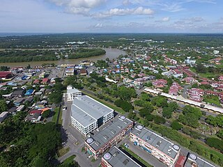
Sibu is a landlocked city located in the central region of Sarawak, Malaysia. It serves as the capital of Sibu District within Sibu Division and is situated on the island of Borneo. Covering an area of 129.5 square kilometres (50.0 sq mi), the city is positioned at the confluence of the Rajang and Igan Rivers, approximately 60 kilometres from the South China Sea and 191.5 kilometres (119 mi) north-east of the state capital, Kuching.

<span class="mw-page-title-main">Sarikei</span> Town and district capital in Sarawak, Malaysia

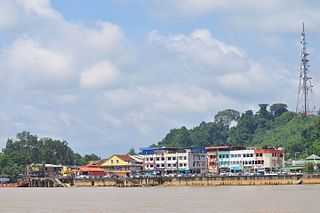
Sarikei is a town, and the capital of Sarikei District in Sarikei Division, Sarawak, Malaysia. It is located on the Rajang River, near where the river empties into the South China Sea. The district population was 56,798.

<span class="mw-page-title-main">Rajang River</span> River in Sarawak, Malaysia

The Rajang River is a river in Sarawak, northwest Borneo, Malaysia. The river originates in the Iran Mountains, flows through Kapit, and then towards the South China Sea. At approximately 565 km long (351 mi), the river is the seventh-longest in Borneo and the longest in Malaysia.

<span class="mw-page-title-main">Tatau</span> Town and district capital in Sarawak, Malaysia

Tatau is a town, and the capital of the Tatau District in Bintulu Division, Sarawak, Malaysia. The district's reported total population for Tatau was 30,383. Tatau became a district in 1987. Before that it was a Sub District under Bintulu District. The main spoken languages are Iban, Kenyah, Beketan and Punan.

<span class="mw-page-title-main">Kanowit</span> Town and district capital in Sarawak, Malaysia

Kanowit is a town and the capital of Kanowit District, Sibu Division, Sarawak, Malaysia, comprising 2,253.5 square kilometres. As of 2010, Kanowit's population is 28,985. It is built on the mouth of Kanowit River at the bank of Rajang River, approximately 174 kilometers from the coast of South China Sea. It takes 45 minutes to reach the town by land transport and an hour by boat from Sibu. The main ethnic groups are Iban, Chinese, Malay, and Melanau.

<span class="mw-page-title-main">Mukah Division</span> Place

Mukah Division is one of the twelve administrative divisions in Sarawak, Malaysia. It was established on 1 March 2002 and it has a total area of 6,997.61 square kilometres.

<span class="mw-page-title-main">Dalat, Sarawak</span> Town and district capital in Sarawak, Malaysia

Dalat is the administrative town of the Dalat district in Mukah Division, Sarawak, Malaysia. It is situated by the Oya river.

Melanau or A-Likou is an ethnic group indigenous to Sarawak, Malaysia. They are among the earliest settlers of Sarawak. They speak in the Melanau language, which is a part of the North Bornean branch of Malayo-Polynesian languages.

<span class="mw-page-title-main">Bintulu</span> Town and district capital in Sarawak, Malaysia

Bintulu is a coastal town on the island of Borneo in the central region of Sarawak, Malaysia. Bintulu is located 610 kilometres northeast of Kuching, 216 kilometres northeast of Sibu, and 200 kilometres southwest of Miri. With a population of 114,058 as of 2010, Bintulu is the capital of the Bintulu District of the Bintulu Division of Sarawak, Malaysia.

Hornbill Skyways Sdn Bhd is a regional aircraft charter service operating in towns and rural areas in Sarawak. The company slogan is "Wings to your Destination".

MASwings Sdn Bhd is a regional airline operating the Rural Air Services (RAS) in Borneo Malaysia. MASwings is the successors of FlyAsianXpress which operates RAS flight from 2006-2007 and FlyAsianXpress is the successors of RAS flights by Malaysia Airlines from 1965-2006, prior to that Borneo Airways which was the first airlines who operate RAS route from 1953-1965 during British Borneo colonization period.

<span class="mw-page-title-main">Sarawak Corridor of Renewable Energy</span>

The Sarawak Corridor of Renewable Energy ("SCORE") is an economic region and development corridor covering central Sarawak, a Malaysian State on the island of Borneo. SCORE was launched in 2008. It is one of the five regional development corridors launched throughout Malaysia during the Abdullah Badawi administration. SCORE is managed by the Regional Corridors Development Authority ("RECODA"), a state government agency created through an Ordinance of the State Legislative Assembly.

<span class="mw-page-title-main">Selangau</span> Town and district capital in Sarawak, Malaysia

Selangau, Sarawak, is a small town located by the Pan Borneo Highway. It is also located by Batang Mukah, a river which flows to the South China Sea. It is located approximately 74 km (46 mi) from Sibu city, 84 km (52 mi) from Mukah town and 134 km (83 mi) from Bintulu town. Selangau town is the administrative centre for the Selangau District.

<span class="mw-page-title-main">Lanang Bridge</span> Bridge in Jalan Lanang Barat / Jalan Teluk Assan

The Lanang Bridge, Sarawak State Route Q326, is a 1.2-km toll bridge in Sibu, Sarawak, Malaysia. It was constructed in 2003 by a local concessionaire, Woodville Development Sdn. Bhd., a subsidiary of Shin Yang Group, to replace the former river ferry service crossing the Batang Rajang. The bridge, together with a series of states highways linking Sibu to Sarikei, forms an alternative route for the Sarikei-Sibu section of the Pan Borneo Highway. Built at the total cost of RM 180 million, the bridge was opened to motorists on 11 April 2006.

<span class="mw-page-title-main">Durin Bridge</span> Bridge in Jalan Sibu-Durin

Durin Bridge or Sibu-Durin Bridge is a bridge connecting Sibu and Durin in Sarawak, Malaysia. The bridge is part of the Jalan Sibu-Durin of the Pan Borneo Highway.

<span class="mw-page-title-main">Sibu District</span> Administrative district in Sarawak, Malaysia


Sibu District is an administrative district in Sibu Division, Sarawak, Malaysia covering a total area of 2229.8 km2. It can be divided into Sibu Town area (129.5 km2) and the rural areas (2,100.3 km2). The satellite township of Sibu Jaya is included in the rural areas. Sibu District is under the purview of Sibu District Office located at Sibu Islamic Complex, Sibu City. There are currently two local authorities namely Sibu Municipal Council (SMC) and Sibu Rural District Council (SRDC) that administers Sibu City and Sibu rural areas respectively.

<span class="mw-page-title-main">Mukah</span> Town and district capital in Sarawak, Malaysia

Mukah (muːkəh), historically known as Muka is a coastal town which serves as the capital and the administrative center of the Mukah Division since 1 March 2002.

<span class="mw-page-title-main">Sarikei District</span> Place

Sarikei District is an administrative district in Sarikei Division, Sarawak, Malaysia, covering an area of 985 square kilometres (380 sq mi). The town of Sarikei is the capital of the Sarikei district.

Kampung Medong is a village located within Dalat District in Mukah Division, Sarawak. The village is located about 6.1 kilometres to the south of Dalat town.

References

  1. 1 2 3 "Tanjung Manis gets RM83m administrative centre". New Sarawak Tribune. 16 November 2022. Archived from the original on 18 February 2023. Retrieved 18 February 2023.
  2. 1 2 3 4 5 6 7 "Sejarah Pentadbiran Daerah Tanjung Manis (History of Tanjung Manis District administration)". Mukah Divisional administration official portal. Archived from the original on 4 August 2019. Retrieved 4 August 2019. Alt URL
  3. "Majlis Pelancaran Koridor Sarawak - Sarawak Corridor of Renewable Energy (SCORE)". Koleksi Arkib Ucapan Ketua Eksekutif. 11 February 2008. Retrieved 31 July 2019.
  4. "Launch of Tanjung Manis Halal Hub". Archived from the original on 4 August 2019. Retrieved 4 August 2019.
  5. "Tanjung Manis". RECODA. Archived from the original on 12 October 2018. Retrieved 4 August 2019.
  6. 1 2 "Tanjung Manis Integrated Port Sdn Bhd Corporate Summary" (PDF). Tanjung Manis Integrated Port. Archived from the original (PDF) on 1 December 2021. Retrieved 25 March 2023.
  7. "Tanjung Manis hari ini: Dari paya bakau bertukar pusat komersial (Tanjung Manis today: from mangroove swap to commercial centre)". Suara Sarawak. 15 January 2022. Archived from the original on 18 February 2023. Retrieved 18 February 2023.
  8. "Addresses". Archived from the original on 4 August 2019. Retrieved 4 August 2019. Alt URL
  9. "Sesar Unjur" (PDF). Pustaka Negeri Sarawak (Sarawak state library). Archived from the original (PDF) on 18 February 2023. Retrieved 18 February 2023.
  10. Anthony, Aga (14 March 2018). "Tanjung Manis set to become administrative hub". The Borneo Post. Archived from the original on 2 August 2018. Retrieved 4 August 2019.
  11. "Lapangan terbang Tanjung Manis: Hubungkan dengan dunia luar (Tanjung Manis airport: communication with the outside world)". Berita Harian. 15 January 2022. Archived from the original on 17 January 2022. Retrieved 18 February 2023.
  12. "Rajang rahsia songket Sarawak (Rajang village holds the secrets of Sarawak songkets)". Berita Harian. 6 March 2019. Archived from the original on 18 February 2023. Retrieved 18 February 2023.
  13. "Tanjung Manis Economic Growth Area (T-Mega)". RECODA. Archived from the original on 12 February 2023. Retrieved 12 February 2023.
  14. 1 2 3 "History of Tanjung Manis Port". Tanjung Manis Integrated Port Sdn Bhd. Archived from the original on 3 December 2020. Retrieved 12 February 2023.
  15. "About Us - Tanjung Manis Port Authority". Tanjung Manis Port Authority. Archived from the original on 14 April 2023. Retrieved 18 April 2023.
  16. Manis, Jane (11 March 2017). "More vessels now docking at Tg Manis Integrated Port". The Borneo Post. Archived from the original on 13 February 2019. Retrieved 15 April 2023.
  17. "Tanjung Manis Port exports RM 1.2 billion from Jan to Sep 2022, expects over RM 4 billion in 2023". Dayak Daily. 14 March 2023. Archived from the original on 21 March 2023. Retrieved 9 April 2023.
  18. "Statistics (2010-2016)". Tanjung Manis Port Authority. Archived from the original on 5 April 2022. Retrieved 10 April 2023.
  19. "An insight into Belawai fishery industry". The Borneo Post. 4 March 2019. Archived from the original on 11 June 2021. Retrieved 12 February 2023.
  20. Sibon, Peter (6 July 2019). "Sarawak moots plan to extend Tanjung Manis Airport". Dayak Daily. Archived from the original on 21 September 2021. Retrieved 12 February 2023.
  21. Andy, Chua. "Better access to beautiful Belawai beach". The Star (Malaysia). Archived from the original on 19 September 2017. Retrieved 4 August 2019.