Tatau District

Last updated

Tatau
Districts of Sarawak
Flag of Sarawak.svg
Sarawakbintulutatau.png
Coordinates: 2°40′00″N113°00′00″E / 2.6667°N 113°E / 2.6667; 113 Coordinates: 2°40′00″N113°00′00″E / 2.6667°N 113°E / 2.6667; 113
District Office locationBintulu
Local area government (s) Lembaga Kemajuan Bintulu (BDA)
Government
  District OfficerJabang Anak Juntan
Area
  Total4,945.80 km2 (1,909.58 sq mi)
Population
 (2010)
  Total30,322
  Density6.1/km2 (16/sq mi)
Ethnicity
   Iban 63.0%
   Chinese 5.2%
   Melanau 9.7%
  Others22.1%
Map of Tatau District Map of Tatau District, Sarawak.svg
Map of Tatau District

Tatau District is one of the two districts of Bintulu Division in Sarawak, Malaysia. It has a total area of 4,945.80 square kilometres. The largest town in the district is Tatau.

Contents

History

Tatau River was once under the control of the Bruneian Empire until 1861 when it was ceded to James Brooke and became part of the Raj of Sarawak. [1]

Demography

The population of Tatau district (year 2010 National Census) was 30,322. [2]

Ethnic groups

Tatau is traditionally a home to Iban, Melanau, Chinese, Malay and Orang Ulu people. There is one ethnic group named "Tatau" which is unique to Tatau district.

Most Ibans are scattered throughout rural areas of Tatau. Whilst, Melanau people (or Melanau Bintulu/Vaie people) and Malay people are concentrated at Tatau and Kuala Tatau. Many Malay people are not originally from Tatau, however, intermarriage with locals especially Melanau people has made Malay as one of the major ethnics in Tatau. Chinese people are more concentrated at Tatau, while some reside at Sangan and Kuala Tatau. The Orang Ulu people, such as Kenyah, Kayan, Tatau, Penan and Punan are more scattered throughout Tatau district compared to the Iban people. Most of them still live deep in the rural areas like Ng. Tau, Kuala Baggiau and Sungai Anap.

There is a large influx of foreign worker population due to the timber industry. It was estimated more than 10% of Tatau population are foreign workers, most of whom come from Indonesia.

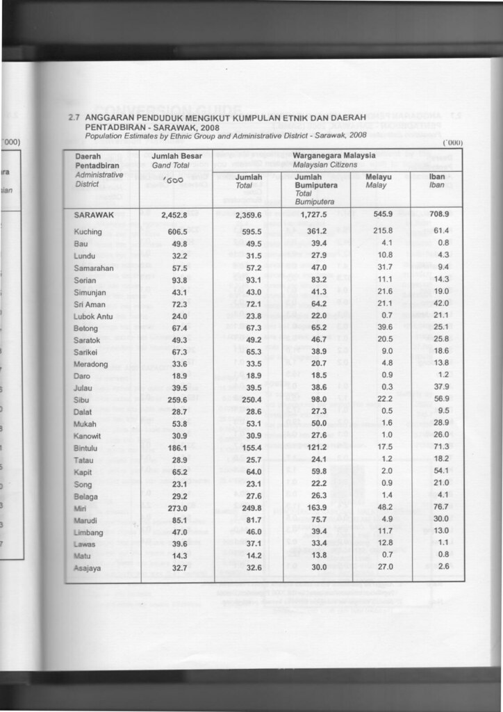
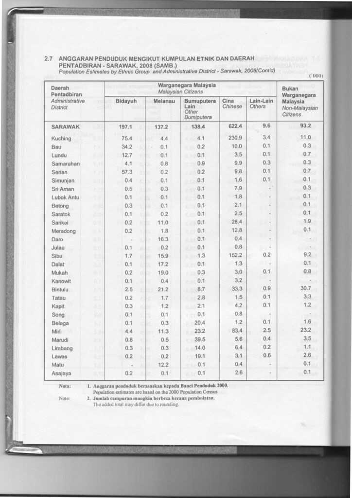
Population of Tatau by Ethnicity [3] [4]
Administrative DistrictTotal
Population
MalayIbanBidayuhMelanauOther
Bumiputera
ChineseOther
Non-Bumiputera
Non-Citizen
Tatau28,900
(100%)
1,200
(4.2%)
18,200
(63.0%)
200
(0.7%)
1,700
(5.9%)
2,800
(9.7%)
1,500
(5.2%)
100
(0.3%)
3,300
(11.4%)

Economy

The economy is largely based on the timber and agricultural industries. Timber industry remains a strong component of the district's economy. Agriculture is relatively minor although growing steadily, with oil palm, rattan and pepper the main products.

Transportation

Although Tatau is well connected to other parts of Sarawak with good networks of road, river transports still play the vital role in Bintulu. People of Tatau District can opt for regular shuttle bus service to Bintulu town, where then connected to other parts of Bintulu Division. The only shuttle bus operating for both town and rural services is Jepak Holding.

As for people who wish to travel to upriver areas which are inaccessible by road such as Kuala Serupai, Kuala Baggiau and Sungai Anap, they have to use available ferry and boat services. River transport charges remain high in Tatau District due to the long distance of the upriver areas.

There are some rural areas which are accessible by timber tracks and palm estate roads such as Kakus. Availability of transports to these areas are limited through bookings at Bintulu town or rarely at Tatau town, using private vans or four-wheel drive vehicles.

Infrastructure

Pan-Borneo Highway is a trunk road linking Tatau District to the rest of Sarawak.

Education

Tatau District has a moderate number of public schools. There is only one public secondary school for Tatau District. As for primary schools, most of them are scattered throughout Tatau. Most of them are located deep in the Tatau District's interior to cater for rural students. Most of the schools are partially boarding school due to the scattered population of Tatau District.

Healthcare

Tatau has its own health clinic with a qualified doctor. However, as for surgeries and more critical cases, they are normally referred to Bintulu Hospital, or to greater extent, Sarawak General Hospital in Kuching.

Security

Tatau District has a police district office. There are also police stations and posts located at strategic locations, as well as rural areas. Despite being the third largest division, Bintulu Division, as well as Tatau District, has no major military presence. There are only small military camps scattered throughout the division.

Government services

Other government offices have set up their branches in both Bintulu and Tatau district (some at Sebauh sub-district and other smaller communal areas) such as Royal Customs, Fire and Rescue Department, Education Department, etc.

See also

Related Research Articles

<span class="mw-page-title-main">Rajang River</span> River in Sarawak, Malaysia

The Rajang River is a river in Sarawak, northwest Borneo, Malaysia. The river originates in the Iran Mountains, flows through Kapit, and then towards the South China Sea. At approximately 565 km long (351 mi), the river is the seventh-longest in Borneo and the longest in Malaysia.

<span class="mw-page-title-main">Kapit</span> Town in Sarawak, Malaysia

Kapit is a town and the capital of Kapit District in Kapit Division, Sarawak, Malaysia on the south bank of the Rajang River. The district comprises 15,595.6 square kilometres and as of 2020, it has a population of 65,800.

<span class="mw-page-title-main">Bintulu Division</span> Division of Sarawak

Bintulu Division is one of the twelve administrative divisions of Sarawak, Malaysia. It has a total area of 12,166.2 square kilometres, and is the third largest division after Kapit Division and Miri Division. Bintulu Division consists of two districts which is Bintulu and Tatau, together with a sub-district under Bintulu, which is Sebauh. Three major towns in Bintulu are Bintulu, Tatau and Sebauh.

Tatau is a town, and the capital of the Tatau District in Bintulu Division, Sarawak, Malaysia. The district's reported total population for Tatau was 30,383. Tatau became a district in 1987. Before that it was a Sub District under Bintulu District. The main spoken languages are Iban, Kenyah, Beketan and Punan.

<span class="mw-page-title-main">Kanowit</span> Place in Sarawak, Malaysia

Kanowit is a town and the capital of a district of the same name, located within the Sibu Division, Sarawak, Malaysia, comprising 2,253.5 square kilometres. As of 2010, Kanowit's population is 28,985. It is built on the mouth of Kanowit River at the bank of Rajang River, approximately 174 kilometers from the coast of South China Sea. It takes 45 minutes to reach the town by land transport and an hour by boat from Sibu. The main ethnic groups are Iban, Chinese, Malay, and Melanau.

<span class="mw-page-title-main">Betong Division</span> Administrative division of Sarawak, Malaysia

Betong Division, formed on 26 March 2002, is one of the twelve administrative divisions in Sarawak, Malaysia. Formerly part of Sri Aman Division, Betong is in the Saribas area. It has a total area of 4,180.8 square kilometres, and is the smallest of the administrative divisions of Sarawak.

<span class="mw-page-title-main">Mukah Division</span> Place

Mukah Division is one of the twelve administrative divisions in Sarawak, Malaysia. It was established on 1 March 2002 and it has a total area of 6,997.61 square kilometres.

<span class="mw-page-title-main">Kuching Division</span> Place

Kuching Division is one of the twelve administrative divisions in Sarawak, Malaysia. Formerly part of what was called the "First Division", it is the center and the starting point of modern Sarawak. Kuching Division has a total area of 4,559.5 square kilometres.

<span class="mw-page-title-main">Melanau people</span> Ethnic

Melanau or A-Likou is an ethnic group indigenous to Sarawak, Malaysia. They are among the earliest settlers of Sarawak. They speak in the Melanau language, which is a part of the North Bornean branch of Malayo-Polynesian languages.

<span class="mw-page-title-main">Limbang Division</span> Division of Sarawak, Malaysia

Limbang Division is one of the twelve administrative divisions of Sarawak, Malaysia. It has a total area of 7,788.50 square kilometres, and is the fourth largest division after Kapit Division, Miri Division and Bintulu Division. Limbang Division consists of two districts which are Limbang District and Lawas District, which in turn are divided as sub-districts in Limbang and two sub-districts in Lawas. Long Semadoh and Ba’kelalan are rural settlements in the southern part of Lawas district. Two major towns in Limbang are Limbang and Lawas. There are also few smaller towns such as Sundar, Trusan, Merapok and Tedungan.

<span class="mw-page-title-main">Bintulu</span> Town in Sarawak, Malaysia

Bintulu is a coastal town on the island of Borneo in the central region of Sarawak, Malaysia. Bintulu is located 610 kilometres (380 mi) northeast of Kuching, 216 kilometres (134 mi) northeast of Sibu, and 200 kilometres (120 mi) southwest of Miri. With a population of 114,058 as of 2010, Bintulu is the capital of the Bintulu District of the Bintulu Division of Sarawak, Malaysia.

<span class="mw-page-title-main">Pakan, Sarawak</span> Town in Sarawak, Malaysia

Pakan is a small town in Pakan District, Sarikei Division, Sarawak, Malaysia. The district population estimates was 17,600.

<span class="mw-page-title-main">Sebauh District</span> District of Bintulu

Sebauh is a district of Bintulu Division, Sarawak, Malaysia. It shares a boundary with Miri, Baram, Kapit Division, Belaga and Tatau. It has a total area of roughly 5,262.90 square kilometres. Sebauh town is a main administrative and economy centre of Sebauh district.

<span class="mw-page-title-main">Bintulu District</span> District of Sarawak

The Bintulu District is one of two districts of Bintulu Division in Sarawak, Malaysia. It has a total area of 7,220.40 square kilometres. Bintulu District has a sub-district, which is Sebauh. There are two towns in Bintulu District, namely Bintulu, which is the capital of both Bintulu District and Bintulu Division, and Sebauh.

<span class="mw-page-title-main">Limbang District</span> District in Sarawak, Malaysia

The Limbang District is one of the two districts of Limbang Division, Malaysia. It has a total area of 3,978.10 square kilometres. The major town is Limbang. It has one sub-district, which is Nanga Medamit Sub-District. It borders Brunei Darussalam to the west and east, Lawas District to the southeast and Miri District at the south and southwest. Due to being squeezed in between Brunei at its north and coastal areas, Limbang is accessible by road only by going through immigration posts.

<span class="mw-page-title-main">Selangau</span> Place

Selangau, Sarawak, is a small town located by the Pan Borneo Highway. It is also located by Batang Mukah, a river which flows to the South China Sea. It is located approximately 74 km (46 mi) from Sibu city, 84 km (52 mi) from Mukah town and 134 km (83 mi) from Bintulu town. Selangau town is the administrative centre for the Selangau District.

<span class="mw-page-title-main">Fort Sylvia</span> Historic fortification in Malaysia

The Fort Sylvia is a historical fort in Kapit, Sarawak, Malaysia. Built in 1880, it was renamed after Rani Sylvia Brooke, wife of Rajah Charles Vyner Brooke, in 1925. During the 1960s, the fort housed the District Office and the District Court House, and later the Resident's Office when Kapit Division was formed in 1973.

Sarawak's population is very diverse, comprising many races and ethnic groups. Sarawak has more than 40 sub-ethnic groups, each with its own distinct language, culture and lifestyle. This makes Sarawak demography very distinct and unique compared to its Peninsular counterpart.

<span class="mw-page-title-main">Data Kakus</span> Place in Sarawak, Malaysia

Data Kakus is a remote Kenyah Badeng village settlement in the hilly interior of the Ulu Kakus Tatau division of Sarawak, Malaysia elevates to 650 metres, not far from Tubau and Belaga district. To be exact, Data Kakus is located at the upstream of Sungai Burok and Sungai Nyabet. The highest peak in Ulu Kakus is called Gunung Lumut about 828m located on the peak of Lumut Range not too far from Sungai Bekuyat and Sungai Kakus.

<span class="mw-page-title-main">Tebedu District</span> District in Sarawak, Malaysia

Tebedu District is a district in the state of Sarawak, Malaysia. It is a part of Serian Division that consists of Serian, Siburan, and Tebedu districts. Before this, Tebedu District was a sub-district under Serian District which was then fully upgraded to a district in its own right. The majority of the population of this district is from the Bidayuh ethnic group.

References

  1. Hughes-Hallet, H. R. (1940). "A Sketch of the History of Brunei". Journal of the Malayan Branch of the Royal Asiatic Society . 18 (2): 38. JSTOR   41559952.
  2. "Laporan Kiraan Permulaan 2010". Jabatan Perangkaan Malaysia. p. 35. Archived from the original on 27 December 2010. Retrieved 24 January 2011.
  3. Sarawak Ethnic Statistic from Sarawak Journal.
  4. Sarawak Ethnic Statistic from Sarawak Journal.