The Jelebu District is the second largest district in Negeri Sembilan, Malaysia after Jempol, with a population over 40,000. Jelebu borders on the Seremban District to its west and Kuala Pilah District to its south, Jempol District to its southeast, Bentong and Bera Districts, Pahang to its east and Hulu Langat District, Selangor to the north. Jelebu is a suburban district with blossoming semi-agricultural industry. Jelebu is also a parliamentary constituency of the Dewan Rakyat in the Malaysian Parliament. Kuala Klawang is the principal town of the district.

Jasin District is one of the three administrative district in Malacca, Malaysia. It borders Tangkak District of Johor to the east, Tampin District of Negeri Sembilan to the north and Alor Gajah District and Melaka Tengah District to the west. The district capital is Jasin Town.

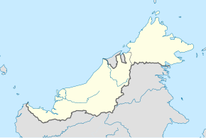
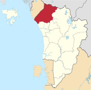
Mukah Division is one of the twelve administrative divisions in Sarawak, Malaysia. It was established on 1 March 2002 and it has a total area of 6,997.61 square kilometres.

The Jempol District is the largest district in the Malaysian state of Negeri Sembilan. The district borders Jelebu District to the northwest, Kuala Pilah District to the west, Tampin District to the south, Bera District, Pahang to the northeast and Segamat District, Johor to the east. Bandar Seri Jempol and Bahau are the principal towns in Jempol.

Dalat is the administrative town of the Dalat district in Mukah Division, Sarawak, Malaysia. It is situated by the Oya river.

The Rompin District is a district located in the southeastern corner of Pahang, Malaysia. Rompin is currently under the Rompin District Council.
The Kubang Pasu District is a district in northern Kedah, Malaysia. It contains the border town of Bukit Kayu Hitam as well as the educational hub of Changlun, while Jitra is the largest town and administrative centre of the district. The district council had been upgraded into municipal council on 22 October 2018, become the fifth city or municipal in the state.
Pakan is a small town in Pakan District, Sarikei Division, Sarawak, Malaysia. The district population estimates was 17,600.

The Seremban District is one of 7 districts in Negeri Sembilan, Malaysia. This is where the capital of Negeri Sembilan, Seremban is located.

The Limbang District is one of the two districts of Limbang Division, Malaysia. It has a total area of 3,978.10 square kilometres. The major town is Limbang. It has one sub-district, which is Nanga Medamit Sub-District. It borders Brunei Darussalam to the west and east, Lawas District to the southeast and Miri District at the south and southwest. Due to being squeezed in between Brunei at its north and coastal areas, Limbang is accessible by road only by going through immigration posts.

Selangau, Sarawak, is a small town located by the Pan Borneo Highway. It is also located by Batang Mukah, a river which flows to the South China Sea. It is located approximately 74 km (46 mi) from Sibu city, 84 km (52 mi) from Mukah town and 134 km (83 mi) from Bintulu town. Selangau town is the administrative centre for the Selangau District.
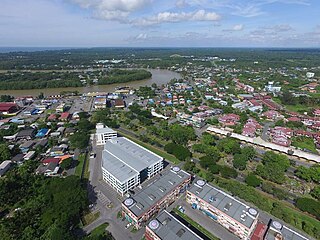
Mukah (muːkəh), historically known as Muka is a coastal town which serves as the capital and the administrative center of the Mukah Division since 1 March 2002.
Tellian is a state constituency in Sarawak, Malaysia, that has been represented in the Sarawak State Legislative Assembly since 2016.
Dalat is a state constituency in Sarawak, Malaysia, that has been represented in the Sarawak State Legislative Assembly since 1991.

The Kota Bharu District is a district in northern Kelantan, Malaysia. As of 2020, the district's population is estimated to be 608,600. It contains the state capital, Kota Bharu, as well as Pengkalan Chepa and Ketereh.
Temerloh District is a district in Pahang, Malaysia. The district consists of two areas, the 1,442-square-kilometre (557 sq mi) Municipal Council Area (64.08%) and the 808-square-kilometre (312 sq mi) outer Municipal Council Area (35.92%). Temerloh district is bordered by Maran District on the east, Bentong District on the west, Jerantut District on the north, and Bera District on the south.
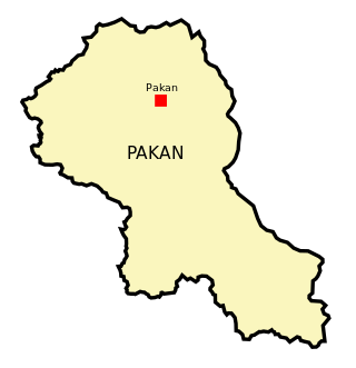
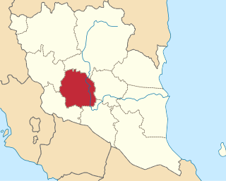
Pakan District is an administrative district in Sarikei Division, Sarawak, Malaysia, covering an area of 924.6 square kilometres (357.0 sq mi). The town of Pakan is the capital of the Pakan district, located 45 km from the town of Sarikei.
Sungai Kut Muara is a village in Dalat District, Mukah Division in the Malaysian state of Sarawak. It is situated in the area where a tributary Kut River meets the larger Igan River. Sungai Kut Muara is about 13 kilometres to the west of Dalat, the district's administrative town.
Kampung Medong is a village located within Dalat District in Mukah Division, Sarawak. The village is located about 6.1 kilometres to the south of Dalat town.