Kanowit | |
|---|---|
 Seal | |
 | |
| Country | |
| State | |
| Division | Sibu |
| Seat | Kanowit |
Kanowit is a district, in Sibu Division, Sarawak, Malaysia. The seat of this district is the town of Kanowit. [1] [2]
Kanowit | |
|---|---|
| Seal | |
| | |
| Country | |
| State | |
| Division | Sibu |
| Seat | Kanowit |
Kanowit is a district, in Sibu Division, Sarawak, Malaysia. The seat of this district is the town of Kanowit. [1] [2]

The Rajang River is a river in Sarawak, northwest Borneo, Malaysia. The river originates in the Iran Mountains, flows through Kapit, and then towards the South China Sea. At approximately 565 km long (351 mi), the river is the fourth-longest in Borneo and the longest in Malaysia.

Kudat Division is an administrative division in the state of Sabah, Malaysia. It occupies the northern tip of Sabah. Its total area of 4,623 square kilometres makes it the smallest of the five divisions of Sabah. The division covers the districts of Kudat, Pitas and Kota Marudu, as well as the islands of Balak, Balambangan, Banggi, Bankawan, Guhuan Utara, Kalampunian and Malawali.

Sandakan Division is an administrative division of Sabah, Malaysia. It stretches diagonally from the northeastern coast of Sabah to the state's central region. With an area of 28,205 square kilometres, it occupies 38.3% of Sabah's territory, and is thus the largest of the five administrative divisions of Sabah. It also has approximately 19.4% of Sabah's total population, with the major inhabitants comprising the Chinese, Orang Sungai, Kadazan-Dusun, Suluk and Bajau Simunul.

West Coast Division is an administrative division of Sabah, Malaysia. It occupies the northwest portion of Sabah. With an area of 7,588 square kilometres, it occupies 10.3% of Sabah's territory. It also has approximately 30% of Sabah's total population, with the main indigenous inhabitants comprising the Bajau, Bisaya, Bruneian Malay, Dusun, Illanun, Kadazan and Kedayan, as well with a significant numbers of Chinese. The division is divided into the districts of Ranau, Kota Belud, Tuaran, Penampang, Papar, and the state capital Kota Kinabalu. The main towns are as in the names of the districts, plus other towns including Putatan, Inanam, Telipok, Tamparuli, Tenghilan and Kinarut.

The Interior Division is an administrative division of the state of Sabah, Malaysia. It occupies the southwest portion of Sabah, bordered by the neighbouring state of Sarawak on its west. With an area of 18,298 square kilometres, it covers 24.9% of Sabah's territory and is home to approximately 14.7% of Sabah's total population. The largest town in the Interior Division is Keningau. Other main towns in this division include Beaufort, Kuala Penyu, Sipitang, Tambunan and Tenom.

Kapit Division, formed on 2 April 1973, is one of the twelve administrative divisions in Sarawak, Malaysia. It has a total area of 38,934 square kilometres, and is the largest of the administrative divisions of Sarawak.

Sibu Division is one of the twelve administrative divisions of Sarawak, Malaysia. It has a total area of 8,278.3 square kilometres, and is the third largest division after Kapit Division and Miri Division.
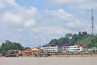
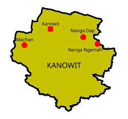
Kanowit is a town and the capital of a district of the same name, located within the Sibu Division, Sarawak, Malaysia, comprising 2,253.5 square kilometres. As of 2010, Kanowit's population is 28,985. It is built on the mouth of Kanowit River at the bank of Rajang River, approximately 174 kilometers from the coast of South China Sea. It takes 45 minutes to reach the town by land transport and an hour by boat from Sibu. The main ethnic groups are Iban, Chinese, Malay, and Melanau.

Julau is a town, and the capital of the Julau District in Sarikei Division, Sarawak, Malaysia. The district population is 15, 333. The population is dominated by Iban as well as Chinese especially the Fuzhou.

Rawalpindi Division is an administrative division of Punjab Province, Pakistan. Rawalpindi city is the capital of the division. According to the 2017 Census of Pakistan, the total population of division was 10 million. Divisions are the third tier of government below the federal and provincial levels.
Wilkins Strait is a natural waterway through the central Canadian Arctic Archipelago. It is mostly in the Northwest Territories, although its eastern extremity is in Nunavut. It separates Borden Island from Brock Island and Mackenzie King Island.
Datuk Aaron Ago anak Dagang is a Malaysian politician who has served as Deputy Minister of Health II for the second term in the Barisan Nasional (BN) administration under Prime Minister Ismail Sabri Yaakob and Minister Khairy Jamaluddin since August 2021. He served his first term in the Perikatan Nasional (PN) administration under former Prime Minister Muhyiddin Yassin and former Minister Adham Baba from March 2020 to August 2021 and the Member of Parliament (MP) for Kanowit since March 2004. He is a member of the Parti Rakyat Sarawak (PRS), a component party of the Gabungan Parti Sarawak (GPS) coalition which is aligned with PN coalition and a former component party of the Barisan Nasional (BN) coalition.

The Fort Sylvia is a historical fort in Kapit, Sarawak, Malaysia. Built in 1880, it was renamed after Rani Sylvia Brooke, wife of Rajah Charles Vyner Brooke, in 1925. During the 1960s, the fort housed the District Office and the District Court House, and later the Resident’s Office when Kapit Division was formed in 1973.
The Kanowit language, also called Serau Tet Kanowit, is an Austronesian language spoken in Sarawak, Malaysia on the island of Borneo. It is mutually intelligible with the Tanjong language, which is spoken even farther upriver near the town of Kapit. Tanjong may be a separate language from Kanowit; however, both languages currently share the denomination kxn in ISO 639-3. Kanowit is primarily spoken in Kampung Bedil, a village located approximately one mile up the Rajang River from Kanowit Town.

The Crown Colony of Sarawak was a British Crown colony on the island of Borneo, established in 1946, shortly after the dissolution of the British Military Administration. It was succeeded as the state of Sarawak through the formation of the Federation of Malaysia on 16 September 1963.

Sibu District is an administrative district in Sibu Division, Sarawak, Malaysia covering a total area of 2229.8 km2. It can be divided into Sibu Town area (129.5 km2) and the rural areas (2,100.3 km2). The satellite township of Sibu Jaya is included in the rural areas. Sibu District is under the purview of Sibu District Office located at Sibu Islamic Complex, Sibu City. There are currently two local authorities namely Sibu Municipal Council (SMC) and Sibu Rural District Council (SRDC) that administers Sibu City and Sibu rural areas respectively.

Kanowit is a federal constituency in Sibu Division, Sarawak, Malaysia, that has been represented in the Dewan Rakyat since 1971.
Kanowit may refer to:
Federal Route 3101 is a federal road in Sibu Division, Sarawak, Malaysia. It is a main route to Kanowit.
Tan Sri Datuk Amar (Dr.) Leo Moggie anak Irok is a Malaysian former politician and former President of Sarawak Native People's Party (PBDS); a splinter party of the Sarawak National Party (SNAP) following the 1983 leadership crisis. He is a former chairman of Tenaga Nasional Berhad (TNB) from 2004 to 2020.
Capital: Kuching | |
| History | |
| Topics | |
| Society |
|
| Administrative divisions | |
Coordinates: 2°00′N112°10′E / 2.000°N 112.167°E
| | This Sarawak location article is a stub. You can help Wikipedia by expanding it. |