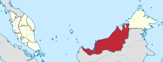
Sarawak is a state of Malaysia. The largest among the 13 states, with an area almost equal to that of Peninsular Malaysia, Sarawak is located in East Malaysia in northwest Borneo, and is bordered by the Malaysian state of Sabah to the northeast, Kalimantan to the south, and Brunei in the north. The state capital, Kuching, is the largest city in Sarawak, the economic centre of the state, and the seat of the Sarawak state government. Other cities and towns in Sarawak include Miri, Sibu, and Bintulu. As of the 2020 Malaysia census, the population of Sarawak was 2.453 million. Sarawak has an equatorial climate with tropical rainforests and abundant animal and plant species. It has several prominent cave systems at Gunung Mulu National Park. Rajang River is the longest river in Malaysia; Bakun Dam, one of the largest dams in Southeast Asia, is located on one of its tributaries, the Balui River. Mount Murud is the highest point in the state. Sarawak is the only state of Malaysia with a Christian majority.

The Bakun Dam is an embankment dam located in Belaga District, Kapit Division, Sarawak, Malaysia, on the Balui River, a tributary or source of the Rajang River and some sixty kilometres east of Belaga. As part of the project, the second-tallest concrete-faced rockfill dam in the world would be built. It would generate 2,400 megawatts (MW) of electricity once completed.

The Rajang River is a river in Sarawak, northwestern Borneo, Malaysia. The river originates in the Iran Mountains, flows through Kapit, and then towards the South China Sea. At approximately 565 km long (351 mi), the river is the seventh-longest in Borneo and the longest in Malaysia.
Punan Bah or Punan is an ethnic group found in Sarawak, Malaysia and Kalimantan, Indonesia. The Punan Bah people are distinct and unrelated to the semi-nomadic Penan people. Their name stems from two rivers along the banks of which they have been living since time immemorial. They have other names including Mikuang Bungulan or Mikuang and Aveang Buan but those are used only ritually nowadays.

Kapit Division, formed on 2 April 1973, is one of the twelve administrative divisions in Sarawak, Malaysia. It has a total area of 38,934 km2 (15,033 sq mi), and is the largest of the administrative divisions of Sarawak.

Kapit is a town and the capital of Kapit District in Kapit Division, Sarawak, Malaysia on the south bank of the Rajang River. The district comprises 15,595.6 square kilometres and as of 2020, it has a population of 65,800.

Bintulu Division is one of the twelve administrative divisions of Sarawak, Malaysia. It has a total area of 12,166.2 km2 (4,697.4 sq mi), and is the third largest division after Kapit Division and Miri Division. Bintulu Division consists of two districts which is Bintulu and Tatau, together with a sub-district under Bintulu, which is Sebauh. Three major towns in Bintulu are Bintulu, Tatau and Sebauh.

Song is a town, and the capital of the Song District in Kapit Division, Sarawak, Malaysia. The district's population was 20,046 according to the 2010 census. Song is situated by the banks of the Katibas River, a tributary of the Rajang River. It is an important stopover for river traffic going up the Rajang River.
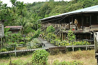
Punan Sama is a small village (longhouse) situated along the Rajang River in Sarawak, Malaysia. The longhouse's previous name was "Lovuk Tepeleang". The majority of those inhabiting the longhouse are Punan, with a few Sekapan, Kejaman and Lahanan, as a result of inter marriage.
Balui River is a river in Sarawak, Malaysia. It is a tributary of the Rajang River. On the river is located the 2,400-megawatt Bakun hydroelectric dam, some sixty kilometres east of Belaga.
Divisions are the primary subdivisions of Sabah and Sarawak, the states in East Malaysia. Each division is subdivided into districts — this is different in Peninsular Malaysia whereby districts are generally the primary subdivisions of a state. Each division is headed by a resident.

The Sarawak Corridor of Renewable Energy is an economic region and development corridor covering central Sarawak, a Malaysian State on the island of Borneo. SCORE was launched in 2008. It is one of the five regional development corridors launched throughout Malaysia during the Abdullah Badawi administration. SCORE is managed by the Regional Corridors Development Authority ("RECODA"), a state government agency created through an Ordinance of the State Legislative Assembly.

The Murum Dam is a gravity dam on the Murum River in Sarawak, Malaysia. Construction began in 2008, the dam's reservoir began to fill in July 2013 and the first generator was commissioned in December 2014. The fourth and final turbine became operational on 8 June 2015. Concerns have been raised about the displacement of the Dayak people and the removal of rainforest due to the construction of the dam.

Tatau District is one of the two districts of Bintulu Division in Sarawak, Malaysia. It has a total area of 4,945.80 square kilometres. The largest town in the district is Tatau.

Sebauh is a district of Bintulu Division, Sarawak, Malaysia. It shares a boundary with Miri, Baram, Kapit Division, Belaga and Tatau. It has a total area of roughly 5,262.90 square kilometres. Sebauh town is a main administrative and economy centre of Sebauh district.

The Bintulu District is one of two districts of Bintulu Division in Sarawak, Malaysia. It has a total area of 7,220.40 square kilometres. Bintulu District has a sub-district, which is Sebauh. There are two towns in Bintulu District, namely Bintulu, which is the capital of both Bintulu District and Bintulu Division, and Sebauh.
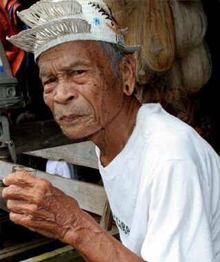
Sarawak's population is very diverse, comprising many races and ethnic groups. Sarawak has more than 40 sub-ethnic groups, each with its own distinct language, culture and lifestyle. This makes Sarawak demography very distinct and unique compared to its Peninsular counterpart. However, it largely mirrors to other territories in Borneo – Sabah, Brunei and Kalimantan.
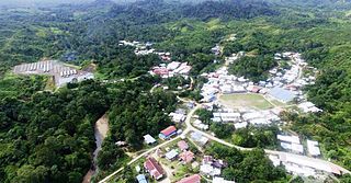
Data Kakus is a remote Kenyah Badeng village settlement in the hilly interior of the Ulu Kakus Tatau division of Sarawak, Malaysia elevates to 650 metres, not far from Tubau and Belaga district. To be exact, Data Kakus is located at the upstream of Sungai Burok and Sungai Nyabet. The highest peak in Ulu Kakus is called Gunung Lumut about 828m located on the peak of Lumut Range not too far from Sungai Bekuyat and Sungai Kakus.
Usun Apau Plieran is a remote abandoned Kenyah Jamuk, Badeng and Lepu Aga' village settled in 1860, Belaga district. To be exact, Usun Apau Plieran is located at the upstream of Sungai Plieran and Sungai Tiyut. The highest peak that close to this area are Bukit Busing 1300m and Mudung Batu Bora about 1450m. There are a few old longhouse sites in this area such as Long Metalon, Long Ampan Aing, Long Bora, Long Taa, Ka Laeh, Lidung Jelo and Lolau Mabo.

Hulu Rajang is a federal constituency in Kapit and Bintulu divisions, Sarawak, Malaysia, that has been represented in the Dewan Rakyat since 1971.

