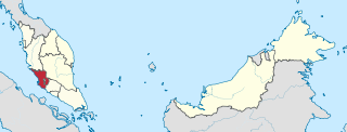
Shah Alam is a city and the state capital of Selangor, Malaysia and situated within the Petaling District and a small portion of the neighbouring Klang District. Shah Alam replaced Kuala Lumpur as the capital city of the state of Selangor in 1978 due to Kuala Lumpur's incorporation into a Federal Territory in 1974. Shah Alam was the first planned city in Malaysia after independence from Britain in 1957.

Selangor, also known by its Arabic honorific Darul Ehsan, or "Abode of Sincerity", is one of the 13 states of Malaysia. It is on the west coast of Peninsular Malaysia and is bordered by Perak to the north, Pahang to the east, Negeri Sembilan to the south, and the Strait of Malacca to the west. Selangor surrounds the federal territories of Kuala Lumpur and Putrajaya, both of which were previously part of it. Selangor has diverse tropical rainforests and an equatorial climate. The state's mountain ranges belong to the Titiwangsa Mountains, which is part of the Tenasserim Hills that covers southern Myanmar, southern Thailand and Peninsular Malaysia, with Mount Semangkok as the highest point in the state.

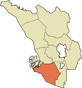
The Sepang District is a district located in the southern part of the state of Selangor in Malaysia. Sepang District covers an area of around 600 square kilometres, and had a population of 190,889 in the 2010 Census.

The Petaling District is a district located in the heart of Selangor in Malaysia. Petaling is not to be confused with the city of Petaling Jaya located in it, nor the mukim of Petaling under Petaling Jaya City. The district office is located in Subang.

Jugra is a mukim, historical town and former royal town in Kuala Langat District, Selangor, Malaysia. It is separated from Pulau Carey by the Langat River. The town is administered by the Zone 16 of the Kuala Langat Municipal Council.

Hulu Langat District is a district located in the southeastern corner of Selangor, between Kuala Lumpur and Negeri Sembilan. It is bordered by the state of Pahang to the east and north, Gombak district to the north-west, Federal Territory of Kuala Lumpur and Petaling district to the west, Sepang district to the south-west, and state of Negeri Sembilan to the south.

The Gombak District is an administrative district located in the state of Selangor, Malaysia. The district was created on February 1, 1974, the same day when Kuala Lumpur was declared a Federal Territory. Until 1997, Rawang was the district capital; the capital has been moved to Bandar Baru Selayang. Gombak borders Kuala Lumpur to the southeast and the Genting Highlands to the east. Both Gombak and Kuala Lumpur, along with some other districts in Selangor, are situated within the Klang Valley. Other localities that are situated in Gombak district include Batu Arang, Kuang, Rawang, Kundang, Gombak Town, Selayang, Batu Caves and Hulu Kelang.

The Sabak Bernam District is a district and a parliamentary constituency in north-western Selangor, Malaysia. It covers an area of 997 square kilometres, and had a population of 103,153 at the 2010 Census. It is situated at the northwestern corner of Selangor. It is bordered by the state of Perak to the north, the district of Hulu Selangor to the east, the district of Kuala Selangor to the south, and the Straits of Malacca to the west. Bernam River forms its border with Perak. Towns in Sabak Bernam include Sabak, Sungai Besar and Sekinchan. This area is also famous for its residents of Javanese descent.

The Kuala Langat District is a district of Selangor, Malaysia. It is situated in the southwestern part of Selangor. It covers an area of 858 square kilometres, and had a population of 307,787 at the 2020 Census. It is bordered by the districts of Klang and Petaling to the north and Sepang to the east. The Strait of Malacca forms its western border.

Sungai Buloh, or Sungei Buloh, is a town, a mukim (commune) and a parliamentary constituency in the northern part of Petaling District, Selangor, Malaysia. The name itself means bamboo river in the Malay language. It is located 16 km NW of downtown Kuala Lumpur and 8 km north of the Subang Airport, along the Kuala Selangor highway.

Puchong is a major town and a parliamentary constituency in Petaling District, Selangor, Malaysia.

Bukit Raja can be referred a mukim in Petaling District, Selangor, Malaysia, that contains several areas in northern Shah Alam which are western part of Section 7 of Shah Alam, Setia Alam (U13), Denai Alam, Bukit Subang, Alam Budiman, Puncak Perdana, Bukit Bandaraya (U11) and National Botanic Gardens Shah Alam. However, definition of Bukit Raja nowadays has shifted south away, which commonly refer to several areas in Klang, that consists of some former oil palm plantation owned by Sime Derby Plantations. The first development of Bukit Raja estate was an industrial area around Bandar Baru Klang and Federal Highway, subsequently Bukit Raja has expanded to the border of Setia Alam with new establishment of “Bandar Bukit Raja” housing project.
Bukit, the Indonesian or Malay word for hill, may refer to:
Damansara is a suburb in Petaling Jaya, a mukim in Petaling District, as well as a parliamentary constituency in Selangor, Malaysia. It is named after the Damansara River which flows nearby. It is one of the most densely populated areas in Malaysia. According to the 2000 Census of Malaysia, it was the second-largest district subdivision in Malaysia in terms of population with 453,420 residents.

Greater Kuala Lumpur is the geographical term that determines the boundaries of metropolitan Kuala Lumpur in Malaysia. Though similar to the term "Klang Valley", there remains a variation between the two. It is similar to Greater London and Greater Toronto. The metropolitan area covers 5,194.72 square km of land.

Negeri FM is a Malay language-radio station broadcasting from Seremban, Negeri Sembilan, Malaysia which is operated by the Radio Televisyen Malaysia (RTM). Negeri FM has been in operation since 1990. It provides the latest news, plays Western music, other entertainment, religious programmes etc. It covers the areas of Negeri Sembilan, Klang Valley, Malacca, northern Johor and parts of Pahang in Malaysia. Negeri FM is transmitted in both standard and Negeri Sembilan Malay. Negeri FM provides hourly news broadcasts. Negeri FM broadcasts in Negeri Sembilan on 92.6 MHz.

The Kuala Selangor District is a district in Selangor, Malaysia. It has a total landmass of 1,194.52 square kilometres separated by Selangor River into two division, Tanjung Karang and Kuala Selangor. The district boundary is shared with Sabak Bernam at the north, Hulu Selangor and Gombak at the west, Petaling at the southwest and Klang at the south.
The following is an alphabetical list of articles related to Selangor.


