Penampang District

Last updated

Penampang District
Daerah Penampang
Other transcription(s)
   Jawi داءيره ڤنمڤڠ
   Chinese 兵南邦县
Bīngnánbāng xiàn(Hanyu Pinyin)
   Tamil பெனாம்பாங் மாவட்டம்
Peṉāmpāṅ māvaṭṭam(Transliteration)
   Kadazandusun Uvang/Watas Penampang
Penampang Sabah MajlisDaerahPenampang-.jpg
Penampang Municipal Council office.
MPP-removebg-preview.png
Etymology: pampang, a Kadazan language word which means 'big rock'
SabahDistricts-Penampang-pp.png
Location of Penampang District in Sabah
Penampang District
Malaysia location map with districts.svg
Red pog.svg
Penampang District
Location of Penampang District in Malaysia
Coordinates: 5°55′00″N116°07′00″E / 5.91667°N 116.11667°E / 5.91667; 116.11667
Country Flag of Malaysia 23px.svg  Malaysia
State Flag of Sabah.svg  Sabah
Division West Coast
Granted
Municipal Status
1 April 2024
Seat Donggongon
Local area government(s)Penampang Municipal Council
Government
  District officerFrancis Chong
Area
  Total
467 km2 (180 sq mi)
Population
 (2020 [1] )
  Total
162,174
  Density350/km2 (900/sq mi)
Time zone UTC+8 (MST)
  Summer (DST) UTC+8 (Not observed)
Postcode
88XXX
Calling code +60-88
Vehicle registration plates SA (1980-2018)
SY (2018-2023)
SJ (2023-)
Website mppenampang.sbh.gov.my
pdpenampang.sbh.gov.my
Map of Penampang District Map of Penampang District, Sabah.svg
Map of Penampang District

The Penampang District (Malay : Daerah Penampang) is an administrative district in the Malaysian state of Sabah, part of the West Coast Division which includes the districts of Kota Belud, Kota Kinabalu, Papar, Penampang, Putatan, Ranau and Tuaran. The capital of the district is in Penampang Town.

Contents

History

Prior to the formation of Penampang District Council (PDC) in 1978, it was formerly known as Jesselton Rural District Council (JRDC). This auxiliary administrative body covered the whole of Penampang sub-district (including Putatan and Lok Kawi), Telipok town including areas up to Kampung Likas, Taman Foh Sang and Taman Stephen. The first head of JRDC was the District Officer of Jesselton, Mr. Blow D.S.O while the Chief Executive was the Assistant District Officer. The councillors comprising the district Chiefs namely: OKK Laiman Diki bin Siram, Majimbun Majangkim, Tan Pin Hing, Ewan Empok and Ahsai Ghani; Chinese Kapitan: Foo Ah Kau (Penampang), Wong Nam Fatt (Telipok), Chin Nyuk (Menggatal), Chin Tsun Yin (Inanam) and Ng Swee Hock (Putatan); Property Owners: Mr. W. C. Collard (Lok Kawi Estate) and Julius Makajil (Penampang). In 1966, the Local Government Ordinance 1961 was amended whereby Councilors are to be appointed by the Minister of Local Government Sabah. When the name Jesselton was changed to Kota Kinabalu, Jesselton Rural District Council (JRDC) was also changed to Kota Kinabalu Rural District Council (KKRDC). In 1978, Kota Kinabalu Town Board was upgraded to Kota Kinabalu Municipal Council hence Kota Kinabalu Rural District Council (KKRDC) became Penampang District Council (PDC). [2]

Demographics

Historical population
YearPop.±%
199186,941    
2000131,072+50.8%
2010121,934−7.0%
2020162,174+33.0%
Source: [1]

According to the last census in 2020, the population of the district is estimated to be around 162,174 inhabitants, [3] with the majority of the population belong to the Kadazan-Dusun ethnic groups and the Chinese. These followed by a minority of Bajau and Bruneian Malay. The Kadazan-Dusuns mainly practice Christianity, the majority of which are Roman Catholic. The Chinese (including of Sino-Native backgrounds) mainly practice Buddhism or Christianity. Malays (mostly of Bruneian descent) and Bajaus are Muslims (they domiciled in the sub-district of Putatan and its surrounding town of Petagas). Penampang was one of the important sites for Roman Catholic early mission in North Borneo. St. Joseph's Foreign Mission Society of Mill Hill, a Roman Catholic mission organisation, began its early missionary works in Papar, Penampang and Sandakan in early 1880s. In 1927, Penampang became the centre of missionary activities in North Borneo and Labuan when Mgr. A. Wachter was appointed the Prefect Apostolic and subsequently made the Penampang mission as his headquarter. [4] The mission work was undoubtedly an important catalyst not only in religion dissemination among the native population of Penampang but also in providing education. The population is divided among the larger communities and the total area of the district as follows:

Penampang (federal constituency) 178,499 inhabitants
N.25 Kapayan 118,966
N.26 Moyog 59,533

Economy

Kodundungan plain. Donggongon Sabah Rice-paddy-02.jpg
Kodundungan plain.

Historically, the main economic activity in Penampang has been the cultivation of wet rice and other agricultural-based economies. In recent years, due to rapid economic boom and its close proximity to Kota Kinabalu, Penampang observes a rapid growth in the secondary and tertiary sectors of economy resulting in a major decline in the traditional agricultural activities. Lands traditionally used for cultivation of wet rice are increasingly sold for commercial and industrial purposes despite prohibition by the local authorities. [5]

Education

S.M. St. Michael is situated in Penampang. It is one of the daily public schools in Sabah. In addition to the school above, Penampang district also hosts to other secondary and primary schools such as SMK Datuk Peter Mojuntin, SMK Bahang, SMK Tansau, SMK Putatan, SMK Limbanak, SJK (C) Yue Min, SK St. Theresa Inobong, SJK (C) Hwa Shiong Putatan, SK Kibabaig, SK St. Joseph, SK Kem Lok Kawi Putatan, SK Penampang, SK St. Anthony Dontozidon, SK Bahang, SK St. Aloysius Limbanak, SK St. Paul Kolopis, SK Putaton Inobong, SK Buit Hill, SK Puuntunoh, SK Tansau, SK Petagas, SK Tombovo, SK Pekan Putatan and SK Sugud to name a few. Tunku Abdul Rahman University College has a branch campus in Donggongon town, while SIDMA College in Bundusan area within the township of Penampang Baru (Bandar Baru Penampang, Koidupan) and INTI College Kota Kinabalu Campus is located in Putatan town.

Tourism

House of skulls in Monsopiad Cultural village, Penampang. KgKuaiKandazon Sabah Monsopiad-House-of-Skulls-01.jpg
House of skulls in Monsopiad Cultural village, Penampang.

Penampang is generally considered as a stronghold of the Kadazan-Dusun community and serves as a main centre for their political and cultural development. The Kadazandusun Cultural Association (KDCA) community hall hosts many of Kadazan-Dusun's traditional festivities, chief among them is the annual Kaamatan or 'harvest festival', their most important cultural event. The Monsopiad Cultural Village is in Penampang. Monsopiad was the name of a past warrior who was known for decapitating the heads of his enemy and hanging the skulls at the entrance of his home, to warn his enemies of his powers. The Pogunon Community Museum, a part of Sabah museum institution is situated in Kg. Pogunon, Penampang. In 2000, during a construction of a local kindergarten, three jars and pieces from four jars were discovered including an intact jar from 16th century with human remains inside. [6] Sabah Art Gallery is situated in Penampang. It houses over 3000 paintings, carvings, and sculptures. The building has a unique basket-shaped architecture with decorative cultural motif panels of the indigenous people of Sabah. It is also the first green building in Sabah and Borneo. St. Michael's Church is a Roman Catholic church built from early 1930s until late 1940s. it is the second oldest stone church in Sabah.

Friendship district

Notable Persons

See also

Related Research Articles

<span class="mw-page-title-main">Kota Kinabalu</span> State capital city and district capital in Sabah, Malaysia

Kota Kinabalu, colloquially referred to as KK, is the state capital of Sabah, Malaysia. It is also the capital of the Kota Kinabalu District as well as the West Coast Division of Sabah. The city is located on the northwest coast of Borneo facing the South China Sea. The Tunku Abdul Rahman National Park lies to its west and Mount Kinabalu, which gave the city its name, is located to its east. Kota Kinabalu has a population of 452,058 according to the 2010 census; when the adjacent Penampang and Tuaran districts are included, the metro area has a combined population of 628,725. The 2020 Census revealed an increase in the municipal population to 500,421, while the wider area including the Penampang and Putatan districts had a population of 731,406.

<span class="mw-page-title-main">Ranau District</span> District in Sabah, Malaysia

The Ranau District is an administrative district in the Malaysian state of Sabah, part of the West Coast Division which includes the districts of Kota Belud, Kota Kinabalu, Papar, Penampang, Putatan, Ranau and Tuaran. The capital of the district is in Ranau Town. The landlocked district bordering the Sandakan Division to the east until it meets the Interior Division border. Ranau sits 108 km (67 mi) east of Kota Kinabalu and 227 km (141 mi) west of Sandakan. As of the 2010 Census, the population of the district was 94,092, an almost entirely Dusun ethnic community.

<span class="mw-page-title-main">West Coast Division</span> Administrative division in Sabah, Malaysia

West Coast Division is an administrative division of Sabah, Malaysia. It occupies the northwest portion of Sabah. With an area of 7,588 square kilometres, it occupies 10.3% of Sabah's territory. It also has approximately 30% of Sabah's total population, with the main indigenous inhabitants comprising the Bajau, Bisaya, Bruneian Malay, Dusun, Illanun, Kadazan and Kedayan, as well with a significant numbers of Chinese. The division is divided into the districts of Ranau, Kota Belud, Tuaran, Penampang, Papar, and the state capital Kota Kinabalu. The main towns are as in the names of the districts, plus other towns including Putatan, Inanam, Telipok, Tamparuli, Tenghilan and Kinarut.
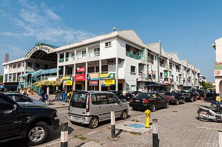
<span class="mw-page-title-main">Penampang</span> Big Town and district capital in Sabah, Malaysia

Penampang is the capital of the Penampang District in the West Coast Division of Sabah, Malaysia. Its population was estimated to be around 93,616 in 2010, with ethnic Kadazan as the majority. It contains, or is synonymous with, Donggongon, which as of 2007, it has a population of 78,086.

<span class="mw-page-title-main">Kadazan-Dusun</span> Ethnic-group from Sabah, Malaysia

Kadazandusun are the largest ethnic group in Sabah, Malaysia, an amalgamation of the closely related indigenous Kadazan and Dusun peoples. "Kadazandusun" is an umbrella term that encompasses both the Kadazan and Dusun peoples. They are also known as Mamasok Sabah, meaning "indigenous people of Sabah". Kadazandusun tradition holds that they are the descendants of Nunuk Ragang. Kadazandusun is recognised as an indigenous nation of Borneo with documented heritage by the United Nations Educational, Scientific and Cultural Organization (UNESCO) since 2004. Kadazandusuns are part of the bumiputera in Malaysia having been endowed with rights concerning land, rivers, education and maintaining their own customary laws.

<span class="mw-page-title-main">Inanam</span> Place in Sabah, Malaysia

Inanam is a suburb and sub-district of Kota Kinabalu in Sabah, Malaysia. It is 10 kilometres from the city centre.
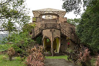
<span class="mw-page-title-main">Nunuk Ragang</span> Location of the original home of the ancestors of the Kadazan-Dusun

Nunuk Ragang is a site traditionally considered as the location of the original home of the ancestors of the Kadazan-Dusun natives who inhabit most of northern Borneo. The site, nearby a village named Tampias, is located at the intersection of the left and right branches of the Liwagu River to the east of Ranau and Tambunan in Sabah. The two river branches joined up to flow into the Labuk river and drain out into the Sulu Sea. At the site, and under a giant banyan tree, a settlement referred to as Nunuk Ragang was founded. The giant banyan tree was said to be able to give shade to a longhouse sheltering 10 families in it. The legend about Nunuk Ragang had been passed down via oral traditions to the younger generations. No archaeological dig has been carried out to establish the veracity of the legend.

<span class="mw-page-title-main">Manggatal</span> Place in Sabah, Malaysia

Menggatal or Manggatal is a Malaysian town and suburb of Kota Kinabalu District on the west coast of Sabah. It is an suburb of the state capital, Kota Kinabalu, and is under the jurisdiction of Kota Kinabalu City Hall. It is located along Jalan Tuaran Lama, which is the main road leading north from Kota Kinabalu city centre all the way to neighbouring Tuaran District.

<span class="mw-page-title-main">Fuad Stephens</span> Former Governor and Chief Minister of Sabah

Muhammad Fuad Stephens, was a Malaysian politician who served as the 1st and 5th Chief Minister of Sabah from September 1963 to December 1964 and again briefly from April 1976 to his death in June 1976, 3rd Yang di-Pertua Negara of Sabah from September 1973 to July 1975, 6th High Commissioner of Malaysia to Australia from 1968 to 1973. In addition, he also served as the 1st Huguan Siou or Paramount Leader of the Kadazandusun community. He played a role in bringing Sabah into the Federation of Malaysia in 1963. While he was initially against the idea of Sabah joining in the Federation, given British concerns about the stability of the region and their move to relinquish all their colonies in the post WWII era, he was gradually convinced to work towards it. He held the chief minister's post from 16 September 1963 until 31 December 1964 when he was forced to resign; and again in 1976 for 54 days from 15 April.

<span class="mw-page-title-main">Datu Mustapha Datu Harun</span> Malaysian politician

Datu Mustapha bin Datu Harun, or Tun Mustapha for short, was a Malaysian politician who served as the 3rd Chief Minister of Sabah from May 1967 to November 1975 and the 1st Yang Di-Pertua Negara from September 1963 to September 1965 and President of the United Sabah National Organisation (USNO). He was an important figure in the negotiations leading to the formation of Malaysia on 16 September 1963.

<span class="mw-page-title-main">Basel Christian Church of Malaysia</span>

The Basel Christian Church of Malaysia or BCCM, formerly known as Borneo Basel Self Established Church, is one of the four Lutheran bodies in Malaysia. In 2009 BCCM had 112 congregations nationwide and 63,000 baptised members. In 2023, BCCM had 64,500 members.

<span class="mw-page-title-main">SMK Datuk Peter Mojuntin</span> National secondary school in penampang, Sabah, Malaysia

Sekolah Menengah Kebangsaan Datuk Peter Mojuntin is one of the secondary schools in Sabah which is located at Penampang, Kota Kinabalu, Malaysia. It is close to Sabah's capital city, Kota Kinabalu.

<span class="mw-page-title-main">Greater Kota Kinabalu</span> Metropolitan area in Sabah, Malaysia

Greater Kota Kinabalu refers to the dense clusters of regional populated areas surrounding the city of Kota Kinabalu in Malaysia. It comprises the districts of Kota Kinabalu, Penampang, Tuaran and Papar. These districts are also part of the West Coast Division. It was forecasted that in 2019, the combined population of these districts was 1.1 million people, in a combined area of 3,277 km2.

<span class="mw-page-title-main">Peter Joinud Mojuntin</span> Malaysian politician

Datuk Peter Joinod Mojuntin, PGDK MLA was a politician in the Malaysian state of Sabah and former State Minister of Local Government and Housing in the government of Tun Fuad Stephens. He died along with other politicians in the Double Six Plane Crash in Kota Kinabalu.

<span class="mw-page-title-main">United Pasokmomogun Kadazan Organisation</span> Political party in Malaysia

The United Pasokmomogun Kadazan Organisation was a Kadazan-Dusun-Murut (KDM) based political party in North Borneo and later Sabah at the time it became a state of Malaysia in the 1960s.

<span class="mw-page-title-main">Kota Belud District</span> District in Sabah, Malaysia

The Kota Belud District is an administrative district in the Malaysian state of Sabah, part of the West Coast Division which includes the districts of Kota Belud, Kota Kinabalu, Papar, Penampang, Putatan, Ranau and Tuaran. The capital of the district is in Kota Belud Town.

<span class="mw-page-title-main">Kota Kinabalu District</span> District in Sabah, Malaysia

The Kota Kinabalu District is an administrative district in the Malaysian state of Sabah, part of the West Coast Division which includes the districts of Kota Belud, Kota Kinabalu, Papar, Penampang, Ranau and Tuaran. The capital of the district is in Kota Kinabalu City.

<span class="mw-page-title-main">Papar District</span> District in Sabah, Malaysia

The Papar District is an administrative district in the Malaysian state of Sabah, part of the West Coast Division which includes the districts of Kota Belud, Kota Kinabalu, Papar, Penampang, Putatan, Ranau and Tuaran. The capital of the district is in Papar Town.

<span class="mw-page-title-main">Putatan District</span> District of Malaysia in Sabah

The Putatan district is an administrative district in the Malaysian state of Sabah, part of the West Coast Division which includes the districts of Kota Belud, Kota Kinabalu, Papar, Penampang, Ranau and Tuaran. The capital of the district is in Putatan Town.

References

  1. 1 2 "Key Findings of Population and Housing Census of Malaysia 2020 Local Authority Area" (pdf) (in Malay and English). Department of Statistics, Malaysia. ISBN   978-967-253-697-0. Archived (PDF) from the original on 24 July 2023. Retrieved 24 July 2023.
  2. "Brief History of Penampang District Council". Penampang District Council. Archived from the original on 9 November 2017. Retrieved 9 November 2017.
  3. "Key Findings of Population and Housing Census of Malaysia 2020" (pdf) (in Malay and English). Department of Statistics, Malaysia. ISBN   978-967-2000-85-3.
  4. Poilis, Fr. William. "A Popular History of the Catholic Church in Sabah".{{cite journal}}: Cite journal requires |journal= (help)
  5. "Preserve the remaining padi fields: NGO". Daily Express. 15 December 2015. Retrieved 23 January 2016.
  6. "Pogunon Community Museum". Sabah Museum. Retrieved 26 October 2014.
  7. "Penampang Council establishes ties with China's Meili Town". The Borneo Post. 19 August 2016. Retrieved 21 August 2016.

Further reading

Commons-logo.svg Media related to Penampang District at Wikimedia Commons