
Sebatik Island is an island off the eastern coast of Borneo, partly within Indonesia and partly within Malaysia. It is one of the 92 officially listed outlying islands of Indonesia.
Lahad Datu is the capital of the Lahad Datu District in the Dent Peninsula on Tawau Division of Sabah, Malaysia. Its population was estimated to be around 27,887 in 2010. The town is surrounded by stretches of cocoa and palm oil plantations. It is also an important timber exporting port. The town has an airport for domestic flights.

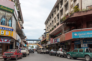
Tawau formerly known as Tawao, is the capital of the Tawau District in Sabah, Malaysia. It is the third-largest town in Sabah, after Kota Kinabalu and Sandakan. It is located on the Semporna Peninsula in the southeast coast of the state in the administrative centre of Tawau Division, which is bordered by the Sulu Sea to the east, the Celebes Sea to the south at Cowie Bay and shares a border with North Kalimantan, Indonesia. The town had an estimated population as of 2010, of 113,809, while the whole municipality area had a population of 397,673.
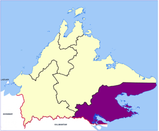
Tawau Division is one of the five administrative sub-divisions of Sabah, Malaysia. It occupies a total of 14,905 square kilometres or 20% of Sabah's territory. The main towns include the capital of Tawau, Lahad Datu, Kunak and Semporna. Tawau division has 26% of Sabah's total population, with the main indigenous groups consisting of the Bajau, Suluk, Ida'an, Tidong, Cocos, Murut, Lun Bawang/Lun Dayeh as well as a minority of mixed ethnic groups. Large numbers of both legal and illegal immigrants from Indonesia such as the Buginese and Torajans, from East Timor the Timorese, from the Philippines the Tausūg and Visayans as well South and West Asian immigrants such as Pakistanis, Indians and Arabs can be found in this area. As with the rest of Sabah, the division also has large numbers of ethnic Chinese.

Tawau Airport is an airport located 15 nautical miles north east of Tawau, Sabah, Malaysia. It is one of two airports in Sabah with immigration counters for international flights, the other being Kota Kinabalu International Airport. Tawau Airport serves the districts of Tawau, Kunak and Semporna and is the nearest airport to the diving islands of Sipadan, Mabul and Kapalai, all of which are located in the latter district.
The states of Malaysia that lie on Borneo are subdivided into divisions. These divisions are further divided into districts.
Kalabakan is a District and also a parliamentary constituency in Sabah, Malaysia. It is located in the Tawau Division, and is about 55 kilometres from Tawau town. Its original name is Kalabakan.
Federal Route 500 is a 163-kilometre (101 mi) federal highway in Sabah, Malaysia, connecting Kota Kinabalu to Tenom. It serves as the main highway from Kota Kinabalu to towns and villages in the Interior Division of Sabah. Federal Route 500 is one of the five highways in Sabah crossing the Crocker Range; the Tamparuli-Ranau Highway, Kimanis-Keningau Highway and Jalan Tenom-Sipitang are the other three and the new highway, Interior North–South Highway.

Sook is a small town and district located in the Interior Division, Sabah, Malaysia. It serves as a timber and agricultural town as well as a transit town for motorists travelling from Keningau to Tawau via the Keningau-Sook-Sapulut-Kalabakan-Tawau road.

Tawau Municipal Council is the municipal council which administrates the town and municipalities area of Tawau in the state of Sabah, Malaysia.

The Al-Kauthar Mosque is a mosque in Tawau, Sabah, Malaysia.

The Batu Tinagat Lighthouse is a lighthouse on Batu Tinagat of Tawau Division in Sabah, Malaysia. It is located approximately 10 kilometres from the Tawau town centre.

The Tawau Bell Tower is the oldest standing structure in Tawau, constructed by the Japanese to commemorate the signing of armistice agreement following World War I when Japan was an ally of Great Britain.
The Kunak District is an administrative district in the Malaysian state of Sabah, part of the Tawau Division which includes the districts of Kunak, Lahad Datu, Semporna and Tawau. The capital of the district is in Kunak Town. Kunak district were part of Lahad Datu before 1990.

The Semporna District is an administrative district in the Malaysian state of Sabah, part of the Tawau Division which includes the districts of Kunak, Lahad Datu, Semporna and Tawau. The capital of the district is in Semporna Town.

The Tawau District is an administrative district in the Malaysian state of Sabah, part of the Tawau Division which includes the districts of Kunak, Lahad Datu, Semporna and Tawau. The capital of the district is in Tawau Town.
Mount Lucia is a volcanic cone mountain located at the Tawau Division of Sabah, Malaysia. It reaches a height of approximately 1,201 metres (3,940 ft).
Borneo Airways Limited also known as Borneo Airways, was the flag carrier and the principal domestic airline in British Borneo based in Labuan between 1957 until 1 April 1965 when it merged with Malaysian Airways.


