Tuaran District | |
|---|---|
| Daerah Tuaran | |
| Other transcription(s) | |
| • Jawi | داءيره توارن |
| • Chinese | 斗亚兰县(Simplified) 鬥亞蘭縣(Traditional) Dòuyàlán xiàn(Hanyu Pinyin) dêu3 a3 lan2 yan4(Hakka) |
| • Tamil | துவாரான் மாவட்டம் Tuvārāṉ māvaṭṭam(Transliteration) |
| • Kadazandusun | Watas Tuaran |
 Tuaran District Office | |
Seal | |
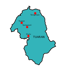
 Map of Tuaran District | |
 Tuaran District | |
| Coordinates: 6°11′00″N116°14′00″E / 6.18333°N 116.23333°E | |
| Country | |
| State | |
| Division | West Coast |
| Administration | Tuaran District Council |
| Government | |
| • District Officer | Herman Tunggiging |
| • Executive Officer | Jamlin Bin Ladin |
| • MP | Wilfred Madius Tangau (UPKO) |
| • MLA | |
| Area | |
• Total | 1,170 km2 (450 sq mi) |
| Population (2020) | |
• Total | 135,665 |
| • Density | 120/km2 (300/sq mi) |
| Time zone | UTC+8 (MST) |
| Postal code | 89XXX |
| Area code | 088 |
| Website | mdtuaran.sbh.gov.my pdtuaran.sbh.gov.my |
The Tuaran District (Malay : Daerah Tuaran) is an administrative district in the Malaysian state of Sabah, part of the West Coast Division which includes the districts of Kota Belud, Kota Kinabalu, Papar, Penampang, Putatan, Ranau and Tuaran. The capital of the district is in Tuaran Town and the administrative area includes the entire boundary of Tuaran District, covering an area of 116,500 hectares (287,875 acres). [1] Tuaran also one of the districts in Sabah located near Kota Kinabalu, and it is considered part of the Greater Kota Kinabalu area. [2]
Contents
- Etymology
- Administration
- Tuaran District Council
- Administrative division
- Members of Sabah State Legislative Assembly
- Towns
- Sub-District
- Geography
- Demographics
- Tourism
- Other Attraction
- Gallery
- See also
- References
- Further reading
- External links
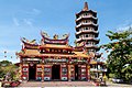
St. Andrews Anglican church was consecrated on 12 November 1967 by Roland Koh. [3]