Petaling District

Last updated
Petaling District
Daerah Petaling
Other transcription(s)
   Jawi ڤتاليڠ
   Chinese 八打灵县
   Tamil பெட்டாலிங்
Daerah Petaling Highlighted in the State of Selangor, Malaysia.svg
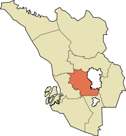
Location of Petaling District in Selangor
Petaling District
Malaysia location map with districts.svg
Red pog.svg
Petaling District
Location of Petaling District in Malaysia
Coordinates: 3°05′N101°35′E / 3.083°N 101.583°E / 3.083; 101.583
Country Flag of Malaysia 23px.svg  Malaysia
State Flag of Selangor.svg  Selangor
Seat Subang, Damansara, Shah Alam, Puchong, Kelana Jaya and Petaling Jaya
Local area government(s) Petaling Jaya City Council
(East)
Shah Alam City Council
(West)
Subang Jaya City Council
(South)
Government
  District officerMisri Idris [1]
   Sultan's RepresentativeEmran Kadir [2]
Area
[3]
  Total484.32 km2 (187.00 sq mi)
Population
 (2020) [4]
  Total2,298,123
  Density4,700/km2 (12,000/sq mi)
Time zone UTC+8 (MST)
  Summer (DST) UTC+8 (Not observed)
Postcode
40xxx, 43xxx, 46xxx, 47xxx
Calling code +6-03-5, +6-03-6, +6-03-7, +6-03-8
Vehicle registration plates B

The Petaling District is a district located in the heart of Selangor in Malaysia. Petaling is not to be confused with the city of Petaling Jaya located in it, nor the mukim of Petaling under Subang Jaya City. The district office is located in Subang.

Contents

The district of Petaling was established on 1 February 1974, the same day Kuala Lumpur was declared a Federal Territory. This district is located in the middle of the Klang Valley adjacent to the capital and thus has experienced tremendous urbanisation. Some of the original forests remain in the Bukit Cherakah Forest Reserve (including the National Botanic Gardens), Kota Damansara Community Forest Park and Bukit Gasing. During the 1991 census, it recorded 633,165 people.[ citation needed ]

The official 2010 census recorded the population of Petaling as 1,660,869 people, excluding foreigners. [4] Petaling is 484.32 km2 in area. [3] The urban centres are divided into the cities of Shah Alam, Petaling Jaya and Subang Jaya. However, there are numerous town subdivisions, old subdistrict administrations (mukim), all of which share the same names like Damansara, Subang, and Petaling, which add much to the administrative confusion along with the rapid growth. Some five types of subdivisions exist for Petaling District, namely the re-organized municipal council majlis, the majlis subdivisions, the community names (also known as townships), electoral constituencies, and the subdivisions ("mukim").

It is host to many thriving townships such as the Damansara area, which hosts several shopping malls including a Tesco and an IKEA outlet. Sultan Abdul Aziz Shah Airport is situated in Subang.

Population

Historical population
YearPop.±%
1991 633,165    
2000 1,184,180+87.0%
2010 1,765,495+49.1%
2020 2,298,123+30.2%
Source: [5]

The following is based on Department of Statistics Malaysia 2010 census. [4]

Ethnic groups in Petaling , 2010 census
Ethnicity PopulationPercentage
Bumiputera 873,78748.20%
Chinese 580,63932.03%
Indian 193,04410.65%
Others13,3990.74%
Total1,812,633100%

Administrative divisions

Map of Petaling District, Selangor.svg

Petaling District is divided into 4 mukims . However, this definition is for historic administrative purposes only and does not reflect the modern rapid growth and subsequent reorganisation in 1997.

  1. Bukit Raja
  2. Sungai Buloh
  3. Damansara
  4. Petaling
District of Petaling, Selangor.png

    Government

    Petaling District and Land Office Petaling District Government Office Complex.jpg
    Petaling District and Land Office
    3 local government jurisdictions of Petaling District, red is Petaling Jaya, Upper white is Shah Alam (there is spillover to Klang District not shown), and lower white is Subang Jaya. Petaling District Selangor Incorporated Cities and Municipalities Petaling Jaya Highlighted.svg
    3 local government jurisdictions of Petaling District, red is Petaling Jaya, Upper white is Shah Alam (there is spillover to Klang District not shown), and lower white is Subang Jaya.

    The district is highly urbanised, and as such, the administration and maintenance of the public facilities in the district have been divided and delegated to the three local governments.

    Shah Alam City Council

    The Shah Alam City Council (MBSA) governs the city centre of Shah Alam. It also exercises jurisdiction over some parts of the south of Klang District, Bukit Raja, Setia Alam, Subang and Sungai Buloh area.

    Petaling Jaya City Council

    The city council (MBPJ) administers the area of the city of Petaling Jaya which includes Damansara (Petaling Jaya Utara, PJU), Petaling Jaya centre and most of Petaling Jaya Selatan (PJS) except PJS7/PJS9/PJS11 (commonly known as Bandar Sunway) which is partially jurisdictional and postcode allocated for location purposes, and SS12-SS19 which previously administrates under MBPJ previous incarnation Petaling Jaya Municipal Council (MPPJ), transferred the administration power to Subang Jaya Municipal Council (MPSJ) on 1997, the same year MPSJ was upgraded from Petaling District Council.[ citation needed ]

    Subang Jaya City Council

    The city council governs the southern parts of the district with the main populated areas such as Subang Jaya, UEP Subang Jaya (USJ), Putra Heights, Batu Tiga, parts of Puchong and Seri Kembangan under its jurisdiction.

    Federal Parliament and State Assembly Seats

    Petaling, Selangor Parliament and State Assembly Electoral Districts Petaling, Federal Parliament and State Assembly Seats.svg
    Petaling, Selangor Parliament and State Assembly Electoral Districts


    List of Petaling district representatives in the Federal Parliament (Dewan Rakyat)

    ParliamentSeat NameMember of ParliamentParty
    P103 Puchong Yeo Bee Yin Pakatan Harapan (DAP)
    P104 Subang Wong Chen Pakatan Harapan (PKR)
    P105 Petaling Jaya Lee Chean Chung Pakatan Harapan (DAP)
    P106 Damansara Gobind Singh Deo Pakatan Harapan (DAP)
    P107 Sungai Buloh Ramanan RamakrishnanPakatan Harapan (PKR)
    P108 Shah Alam Azli YusofPakatan Harapan (AMANAH)
    P109 Kapar Halimah AliPerikatan Nasional (PAS)
    P111 Kota Raja Mohamad Sabu Pakatan Harapan (AMANAH)


    List of Petaling district representatives in the State Legislative Assembly (Dewan Undangan Negeri)

    ParliamentStateSeat NameState AssemblymanParty
    P102N28Sri KembanganWong Siew KiPakatan Harapan (DAP)
    P103N29Seri SerdangAbbas AzmiPakatan Harapan (AMANAH)
    P104N30KinraraNg Sze HanPakatan Harapan (DAP)
    P104N31Subang JayaMichelle Ng Mei SzePakatan Harapan (DAP)
    P105N32Seri SetiaFahmi NgahPakatan Harapan (PKR)
    P105N33Taman MedanAfif BahardinPerikatan Nasional (BERSATU)
    P105N34Bukit GasingRajiv RishyakaranPakatan Harapan (DAP)
    P106N35Kampung TunkuLim Yi WeiPakatan Harapan (DAP)
    P106N36Bandar UtamaJamaliah JamaluddinPakatan Harapan (DAP)
    P106N37Bukit LanjanPua Pei LingPakatan Harapan (PKR)
    P107N38Paya JarasAbdul Halim TamuriPerikatan Nasional (PAS)
    P107N39Kota DamansaraMuhammad Izuan KasimPakatan Harapan (PKR)
    P108N40Kota AnggerikMohd Najwan HalimiPakatan Harapan (PKR)
    P108N41Batu TigaDanial Al RashidPakatan Harapan (AMANAH)
    P109N42MeruMariam Abdul RashidPakatan Harapan (AMANAH)
    P111N50Kota KemuningPreakas SampunathanPakatan Harapan (DAP)

    See also

    Related Research Articles

    <span class="mw-page-title-main">Shah Alam</span> City and state capital in Selangor, Malaysia

    Shah Alam is a city and the state capital of Selangor, Malaysia and situated within the Petaling District and a small portion of the neighbouring Klang District. Shah Alam replaced Kuala Lumpur as the capital city of the state of Selangor in 1978 due to Kuala Lumpur's incorporation into a Federal Territory in 1974. Shah Alam was the first planned city in Malaysia after independence from Britain in 1957.

    <span class="mw-page-title-main">Selangor</span> State of Malaysia

    Selangor, also known by its Arabic honorific Darul Ehsan, or "Abode of Sincerity", is one of the 13 states of Malaysia. It is on the west coast of Peninsular Malaysia and is bordered by Perak to the north, Pahang to the east, Negeri Sembilan to the south, and the Strait of Malacca to the west. Selangor surrounds the federal territories of Kuala Lumpur and Putrajaya, both of which were previously part of it. Selangor has diverse tropical rainforests and an equatorial climate. The state's mountain ranges belong to the Titiwangsa Mountains, which is part of the Tenasserim Hills that covers southern Myanmar, southern Thailand and Peninsular Malaysia, with Mount Semangkok as the highest point in the state.

    <span class="mw-page-title-main">Sepang District</span> District of Malaysia in Selangor

    The Sepang District is a district located in the southern part of the state of Selangor in Malaysia. Sepang District covers an area of around 600 square kilometres, and had a population of 190,889 in the 2010 Census.

    <span class="mw-page-title-main">Petaling Jaya</span> City in Selangor, Malaysia

    Petaling Jaya, colloquially referred to as "PJ", is a city in Petaling District, in the state of Selangor, Malaysia. Originally developed as a satellite township for Kuala Lumpur, the capital of Malaysia, it is part of the Greater Kuala Lumpur area. Petaling Jaya was granted city status on 20 June 2006. It has an area of approximately 97.2 square kilometres (37.5 sq mi).

    <span class="mw-page-title-main">Hulu Langat District</span> District of Malaysia in Selangor

    Hulu Langat District is a district of Malaysia located in the southeastern corner of Selangor, between Kuala Lumpur and Negeri Sembilan. It is bordered by the state of Pahang to the east and north, Gombak district to the north-west, Federal Territory of Kuala Lumpur and Petaling district to the west, Sepang district to the south-west, and state of Negeri Sembilan to the south.

    <span class="mw-page-title-main">Subang Jaya</span> City in Selangor, Malaysia

    Subang Jaya is a city in Petaling District, Selangor, Malaysia. It comprises the southern third district of Petaling. It consists of the neighbourhoods from SS12 to SS19, UEP Subang Jaya (USJ), Putra Heights, Batu Tiga as well as PJS7, PJS9 and PJS11 of Bandar Sunway, the latter of which are partially jurisdictional within Petaling Jaya under the MBPJ. The city is governed by Subang Jaya City Council (MBSJ), which also governs other areas of the Petaling district, such as Puchong and Seri Kembangan. According to Subang Jaya City Council, Subang Jaya has a population of 968,930 in 2020, which makes it the sixth largest city in Malaysia by population.

    <span class="mw-page-title-main">Gombak District</span> District of Malaysia in Selangor

    The Gombak District is an administrative district located in the state of Selangor, Malaysia. The district was created on February 1, 1974, the same day when Kuala Lumpur was declared a Federal Territory. Until 1997, Rawang was the district capital; the capital has been moved to Bandar Baru Selayang. Gombak borders Kuala Lumpur to the southeast and the Genting Highlands to the east. Both Gombak and Kuala Lumpur, along with some other districts in Selangor, are situated within the Klang Valley. Other localities in Gombak district include Batu Arang, Kuang, Rawang, Kundang, Gombak Town, Selayang, Batu Caves and Hulu Kelang.

    <span class="mw-page-title-main">Kuala Langat District</span> District of Malaysia in Selangor

    The Kuala Langat District is a district of Selangor, Malaysia. It is situated in the southwestern part of Selangor. It covers an area of 858 square kilometres, and had a population of 307,787 at the 2020 Census. It is bordered by the districts of Klang and Petaling to the north and Sepang to the east. The Strait of Malacca forms its western border.

    <span class="mw-page-title-main">Sungai Buloh</span> Place in Selangor, Malaysia

    Sungai Buloh, or Sungei Buloh, is a town, a mukim (commune) and a parliamentary constituency in the northern part of Petaling District, Selangor, Malaysia. The name itself means bamboo river in the Malay language. It is located 16 km NW of downtown Kuala Lumpur and 8 km north of the Subang Airport, along the Kuala Selangor highway.

    <span class="mw-page-title-main">Puchong</span> Town in Selangor, Malaysia

    Puchong is a major town and a parliamentary constituency in Petaling District, Selangor, Malaysia.

    <span class="mw-page-title-main">Subang, Selangor</span> Place in Selangor, Malaysia

    Subang is a township in Petaling District, Selangor, Malaysia. It is located about 17 km west of downtown Kuala Lumpur.

    <span class="mw-page-title-main">Sunway City</span> Township in Subang Jaya, Selangor, Malaysia

    Sunway City is an 800-acre integrated township in Subang Jaya, Selangor, Malaysia. This township is named after its developer, Sunway Group, which had also got its name from Sungai Way, a suburb in Selangor.

    <span class="mw-page-title-main">Putra Heights</span> Town in Selangor, Malaysia

    Putra Heights is a residential township in Subang Jaya, Selangor, Malaysia. It is located within the mukim of Petaling District. The township is visible by the tall Bukit Cermin in Putra Heights.

    Damansara is a suburb in Petaling Jaya, a mukim in Petaling District, as well as a parliamentary constituency in Selangor, Malaysia. It is named after the Damansara River which flows nearby. It is one of the most densely populated areas in Malaysia. According to the 2000 Census of Malaysia, it was the second-largest district subdivision in Malaysia in terms of population with 453,420 residents.

    <span class="mw-page-title-main">Greater Kuala Lumpur</span> Metropolitan area in Malaysia

    Greater Kuala Lumpur is the geographical term that determines the boundaries of metropolitan Kuala Lumpur in Malaysia. Though similar to the term "Klang Valley", there remains a variation between the two. It is similar to Greater London and Greater Toronto. The metropolitan area covers 5,194.72 square km of land.

    <span class="mw-page-title-main">Klang District</span> District of Malaysia in Selangor

    The Klang District is a district in Selangor, Malaysia. It is located in the western part of Selangor. It borders the Kuala Selangor District to the north, Petaling to the east, Kuala Langat district to the south and Malacca Straits to the west. The district was further divided into two mukims which is Klang and Kapar that covers 626.78 square km of land with 53.75 km of coastline.

    <span class="mw-page-title-main">Kuala Selangor District</span> District in Selangor, Malaysia

    The Kuala Selangor District is a district in Selangor, Malaysia. It has a total landmass of 1,194.52 square kilometres separated by Selangor River into two division, Tanjung Karang and Kuala Selangor. The district boundary is shared with Sabak Bernam at the north, Hulu Selangor and Gombak at the west, Petaling at the southwest and Klang at the south.

    The following is an alphabetical list of articles related to Selangor.

    <span class="mw-page-title-main">Subang Jaya City Council</span>

    Subang Jaya City Council is the city council which is in charge of the Subang Jaya city and the southern parts of Petaling district. This agency is under Selangor state government of Malaysia. MBSJ are responsible for the public's health and sanitation, waste removal and management, town planning, environmental protection and building control, social and economic development and general maintenance functions of urban infrastructure. The MBSJ headquarters is located in UEP Subang Jaya.

    References

    1. "Portal Rasmi PDT Petaling Senarai Pegawai Daerah Petaling". www2.selangor.gov.my.
    2. "Portal Rasmi PDT Petaling Orang Besar Daerah". www2.selangor.gov.my.
    3. 1 2 "Portal Rasmi PDT Petaling Sejarah Daerah Petaling". www2.selangor.gov.my.
    4. 1 2 3 "Population Distribution and Basic Demographic Characteristics, 2010" (PDF). Department of Statistics, Malaysia. Archived from the original (PDF) on 22 May 2014. Retrieved 19 April 2012.
    5. "Key Findings of Population and Housing Census of Malaysia 2020" (pdf) (in Malay and English). Department of Statistics, Malaysia. ISBN   978-967-2000-85-3.