This article needs additional citations for verification .(September 2014) |
Kuala Selangor | |
---|---|
Town and district capital | |
Other transcription(s) | |
• Jawi | كوالا سلاڠور |
• Chinese | 瓜拉雪兰莪(Simplified) 瓜拉雪蘭莪(Traditional) Guālā Xuělán'é(Hanyu Pinyin) |
• Tamil | கோலா சிலாங்கூர் Kōlā Cilāṅkūr(Transliteration) |
Nickname(s): Kuala Selangor, Beautiful and Historic | |
Coordinates: 3°19′59.52″N101°15′15.12″E / 3.3332000°N 101.2542000°E | |
Country | Malaysia |
State | Selangor |
District | Kuala Selangor District |
Granted municipal status | 7 August 2021 |
Government | |
• Type | Municipal council |
• Body | Kuala Selangor Municipal Council |
• Council President | Rahilah binti Rahmat |
Postal code | 45xxx |
Area code(s) | 03-3xxxxxxx |
Vehicle registration | B |
Website | www |
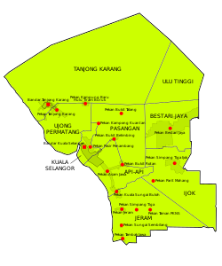
Kuala Selangor is a town in northwestern Selangor, Malaysia. It is the largest town and administrative centre of the coterminous Kuala Selangor District.
The name Kuala Selangor means Estuary of the Selangor River.
Kuala Selangor was the capital of the Sultanate of Selangor during its early years in the 18th century. [1] It was relocated to Jugra in Kuala Langat District in 1827, then Klang in the 1870s.
Kuala Selangor town is located at the estuary of the Selangor River, where it drains into the Strait of Malacca. It is located 55 km north-west of downtown Kuala Lumpur, and 42 km north-west of Shah Alam, the capital of Selangor.
Kuala Selangor town is the largest town of the coterminous Kuala Selangor District, which also contains the adjacent towns of Tanjung Karang, Ijok, Puncak Alam, Bestari Jaya and Jeram. [2]
Kampung Kuantan is well known for its fireflies. Firely tourism in the area began in the early 1970s. Now, tourism is managed by the Kuala Selangor District Council and has expanded rapidly with the addition of 27 small boats for the visitors.[ citation needed ]
Kuala Selangor Nature Park was opened in 1987. With an area of 296 hectares (2.96 km2), it is divided to two main parts: a 201-hectare (2.01 km2) Tropical Rainforest, and a Swamp Forest. The park is under the management of the Malaysia Nature Lovers Association, ensuring the natural environment of the park is preserved without any habitat damage.[ citation needed ]
Kuala Selangor is connected to Sungai Buloh and Kepong by national highway 54. This is the main access road from downtown Kuala Lumpur. The Kuala Lumpur-Kuala Selangor toll road (LATAR) E25 is another access route, providing access from Rawang. The upcoming West Coast Expressway will provide access to Banting, Klang, Teluk Intan, Ipoh and Taiping.
Kuala Selangor is also accessible from the royal capital Klang via national highway 5.
Kuala Selangor currently is not connected to any rail transit line. However, Selangor Omnibus route 100 runs from AG7 SP7 KJ13 LRT Masjid Jamek, KA07 KTM Kepong Sentral and PY04 KA08 MRT/KTM Sungai Buloh between 05:00 and 20:00 daily. [3]
A branch line of the KTM Tanjung Malim-Port Klang Line once connected Kuala Selangor to Padang Jawa; the line was closed in 1933.
Shah Alam is a city and the state capital of Selangor, Malaysia and situated within the Petaling District and a small portion of the neighbouring Klang District. Shah Alam replaced Kuala Lumpur as the capital city of the state of Selangor in 1978 due to Kuala Lumpur's incorporation into a Federal Territory in 1974. Shah Alam was the first planned city in Malaysia after independence from Britain in 1957.
Selangor, also known by its Arabic honorific Darul Ehsan, or "Abode of Sincerity", is one of the 13 states of Malaysia. It is on the west coast of Peninsular Malaysia and is bordered by Perak to the north, Pahang to the east, Negeri Sembilan to the south, and the Strait of Malacca to the west. Selangor surrounds the federal territories of Kuala Lumpur and Putrajaya, both of which were previously part of it. Selangor has diverse tropical rainforests and an equatorial climate. The state's mountain ranges belong to the Titiwangsa Mountains, which is part of the Tenasserim Hills that covers southern Myanmar, southern Thailand and Peninsular Malaysia, with Mount Semangkok as the highest point in the state.
The Gombak District is an administrative district located in the state of Selangor, Malaysia. The district was created on February 1, 1974, the same day when Kuala Lumpur was declared a Federal Territory. Until 1997, Rawang was the district capital; the capital has been moved to Bandar Baru Selayang. Gombak borders Kuala Lumpur to the southeast and the Genting Highlands to the east. Both Gombak and Kuala Lumpur, along with some other districts in Selangor, are situated within the Klang Valley. Other localities that are situated in Gombak district include Batu Arang, Kuang, Rawang, Kundang, Gombak Town, Selayang, Batu Caves and Hulu Kelang.
Federal Route 54, or Jalan Kuala Selangor–Kepong or Jalan Kepong in Kuala Lumpur side, is a main federal road in Selangor, Malaysia. The road connects Asam Jawa near Kuala Selangor to Kepong near Kuala Lumpur. It is a main route to Kuala Lumpur from Federal Route 5. Federal Route 54 became the backbone of the road system linking Kuala Selangor to Kuala Lumpur before being surpassed by the Kuala Lumpur–Kuala Selangor Expressway E25 in 2011.
Sungai Buloh, or Sungei Buloh, is a town, a mukim (commune) and a parliamentary constituency in the northern part of Petaling District, Selangor, Malaysia. The name itself means bamboo river in the Malay language. It is located 16 km NW of downtown Kuala Lumpur and 8 km north of the Subang Airport, along the Kuala Selangor highway.
Bandar Sri Damansara is a residential township in Petaling District, Selangor, Malaysia. The township is divided into two sections, SD1-SD5 in the north and SD7-SD15 in the south which are separated by Kuala Selangor-Kepong Highway. It is adjacent to Kepong and Sungai Buloh. The township consists of mixed development of commercial and residential properties. It was previously developed by Land and General Berhad and currently by TA Global.
Kepong is a town in northern Kuala Lumpur, Malaysia. The name is a Malay word meaning "Enclose" or "Surround", as the town is surrounded by a mountain range.
Subang is a township in Petaling District, Selangor, Malaysia. It is located about 17 km west of downtown Kuala Lumpur.
Puncak Alam is a township in Kuala Selangor District, Selangor, Malaysia.
The KTM Tanjung Malim–Port Klang Line, formerly known as the Port Klang Line is one of the three KTM Komuter Central Sector lines provided by Keretapi Tanah Melayu. The electric trains run between Tanjung Malim and Port Klang. Prior to 15 December 2015, the northern terminus of this line was Batu Caves.
Transport in Greater Kuala Lumpur includes a road network, a railway network, airports, and other modes of public transport. Greater Kuala Lumpur is conterminous with the Klang Valley, an urban conglomeration consisting of the city of Kuala Lumpur, as well as surrounding towns and cities in the state of Selangor. The Klang Valley has the country's largest airport, the Kuala Lumpur International Airport (KLIA), as well as the country's largest intermodal transport hub and railway station, Kuala Lumpur Sentral.
The Sungai Buloh station is an integrated railway station serving the suburb of Sungai Buloh in Selangor, Malaysia, which is located to the northwest of Kuala Lumpur.
Bestari Jaya(formerly Batang Berjuntai) is a town and a mukim in Kuala Selangor District, Selangor, Malaysia. It is 40 km NW from Kuala Lumpur.
Kampung Sungai Penchala is a small Malay village in the Segambut constituency in northwestern Kuala Lumpur, Malaysia, with the postcode 60000 KUALA LUMPUR, lying along the Federal Territory–Selangor border. This village is next to Taman Tun Dr Ismail in Kuala Lumpur, Malaysia which also shares the same 60000 KUALA LUMPUR postcode, and adjacent to Mutiara Damansara and Bandar Utama that were once part of a large oil palm plantation across the interstate border.
Valencia is a residential township in Sungai Buloh, Selangor, Malaysia.
Greater Kuala Lumpur is the geographical term that determines the boundaries of metropolitan Kuala Lumpur in Malaysia. Though similar to the term "Klang Valley", there remains a variation between the two. It is similar to Greater London and Greater Toronto. The metropolitan area covers 5,194.72 square km of land.
Kota Puteri is a township in Gombak District, Selangor, Malaysia, developed by the PKNS. The town is alternately known as Bandar Baru Batu Arang. It is divided into 12 sections.
The KTM Batu Caves–Pulau Sebang Line, formerly known as the Seremban Line is one of the three KTM Komuter Central Sector lines provided by Keretapi Tanah Melayu. Its electric trains run between Batu Caves and Pulau Sebang/Tampin. Prior to 15 December 2015, the northern terminus of this line was Rawang.
The Kuala Selangor District is a district in Selangor, Malaysia. It has a total landmass of 1,194.52 square kilometres separated by Selangor River into two division, Tanjung Karang and Kuala Selangor. The district boundary is shared with Sabak Bernam at the north, Hulu Selangor and Gombak at the west, Petaling at the southwest and Klang at the south.
The following is an alphabetical list of articles related to Selangor.