Cheras is a suburban and a district, straddling both the Federal Territory of Kuala Lumpur and Hulu Langat District in the state of Selangor, Malaysia.

Wangsa Maju is a township and a constituency in Kuala Lumpur, Malaysia. This area is surrounded by Setapak, Taman Melati and Gombak district in Selangor. Wangsa Maju is one of the major suburbs in Kuala Lumpur.

Setapak is a town and mukim straddling both norteastern Kuala Lumpur and Gombak District of Selangor, Malaysia.
Lembah Pantai is a sub-district and parliamentary constituency in south-western Kuala Lumpur, Malaysia. Constituencies adjacent to Lembah Pantai are Seputeh, Segambut and Bukit Bintang. The total number of population is 148,094 as of 2020 census.

Setiawangsa is an eastern suburb in Kuala Lumpur, Malaysia, located less than 4 kilometres from the city centre and located right next to Ampang. There are 4 main residentials within this area;
- Taman Setiawangsa
- Tiara Setiawangsa
- Bukit Setiawangsa
- Puncak Setiawangsa

Kampung Datuk Keramat or more commonly referred to as Keramat among the locals is a large zone in the Titiwangsa constituency, falling within the boundary of the Federal Territory of Kuala Lumpur, Malaysia. It is located northeast of downtown Kuala Lumpur and borders the district of Ampang in Selangor. The Klang River runs roughly from northeast to the west and acts as a natural divider of Keramat and Ampang.

Ulu Kelang, is a mukim and a state constituency in Gombak District, Selangor, Malaysia. It is one of five state constituencies administered by Majlis Perbandaran Ampang Jaya (MPAJ).

Ampang Jaya, more commonly known as just Ampang, is a town, a mukim and a parliamentary constituency straddling parts of the Hulu Langat District and Gombak District, in eastern Selangor, Malaysia. It is located just outside the eastern border of Kuala Lumpur Federal Territory.

Setiawangsa LRT station is an elevated rapid transit station in Ampang, Malaysia, forming part of the Kelana Jaya Line. The station was opened on June 1, 1999, as part of the line's second segment encompassing 12 stations between Masjid Jamek station and Gombak and an underground line.
Landslides in Malaysia are regular natural disasters in Malaysia which occur along hillsides and steep slopes.
Lembah Keramat is a place in Ulu Kelang, Gombak District, Selangor, Malaysia, but use Kuala Lumpur postcode. It is known as a Malay reserved residential area.
Taman CUEPACS is a major township in Cheras, Selangor, Malaysia. Taman CUEPACS is located near Pasukan Gerakan Am (PGA) police base. The township gets its name from the abbreviation of CUEPACS which means Congress of Unions of Employees in the Public and Civil Services.
Yaacob bin Abdul Latiff was the second Mayor of Kuala Lumpur, Malaysia since it was officially conferred the status of the city on 16 May 1972. He served for a period of 8 years. On 1 November 1980, he was succeeded by Elyas Omar.

Greater Kuala Lumpur is the geographical term that determines the boundaries of metropolitan Kuala Lumpur in Malaysia. Though similar to the term "Klang Valley", there remains a variation between the two. The metropolitan area covers 13,565.61square km of land.

The Kuala Lumpur Library is the main library of Kuala Lumpur, Malaysia. It has 15 branches around Kuala Lumpur :

Taman Putra Perdana is a township in Dengkil sub-district, Sepang District, Selangor, Malaysia. Although the township's postcode is 47100 / 47120 / 47130, which gives it Puchong postal address, it is actually in the Sepang constituency of Selangor, administered by the Sepang Municipal Council (MPSepang). The township was developed by Kenshine Corporation in 1997.
Karamat in Sunni Islam refers to supernatural wonders performed by Muslim saints.

Setiawangsa–Pantai Expressway (SPE) is a 29.8-kilometre (18.5 mi) expressway in Klang Valley, Malaysia that connects Taman Melati and Klang Gates from FT 28 Kuala Lumpur Middle Ring Road 2 to Sprint Expressway - Kerinchi Link and FT 2 Federal Highway at Kerinchi near Pantai and University of Malaya. The alignment of this highway will traverse north to south of Kuala Lumpur and will serve areas such as Tunku Abdul Rahman University of Management and Technology, Wangsa Maju, Setiawangsa, Ampang, the Tun Razak Exchange and Bandar Malaysia development corridor as well as providing a connection to Kuala Lumpur-Karak Experessay to the east coast. It was built and maintained by Ekovest Berhad. It is formerly known as DUKE Phase 3.

The National Sports Council of Malaysia, is a government agency and statutory body under the Ministry of Youth and Sports of the Government of Malaysia which governs the sporting activities in Malaysia. It was established under National Sports Council of Malaysia Act 1971 and launched by the second Prime Minister of Malaysia, Abdul Razak Hussein on 21 February 1972.
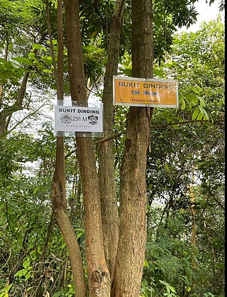
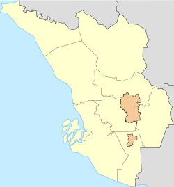
Bukit Dinding is a forested hill with published height of 291m in Kuala Lumpur sitting in between Setiawangsa and Wangsa Maju. There are variation of heights in different records where according to Google Earth (2022), the height of Bukit Dinding is 302m, but according to Kuala Lumpur Slope Information System (KULSIS), it is 311m.