Setiawangsa LRT station

Last updated
 KJ5  Setiawangsa
Rapid KL Logo.svg
Light rapid transit (LRT) station
Setiawangsa LRT.jpg
General information
Other names斯迪亚旺沙 (Chinese)
செதியாவன்க்ச (Tamil)
LocationJalan Jelatek
AU1, Taman Setiawangsa
54200, Kuala Lumpur
Malaysia
Coordinates 3°10′32.57″N101°44′09.09″E / 3.1757139°N 101.7358583°E / 3.1757139; 101.7358583 Coordinates: 3°10′32.57″N101°44′09.09″E / 3.1757139°N 101.7358583°E / 3.1757139; 101.7358583
Owned by Prasarana Malaysia
Operated by Rapid Rail
Line(s) 5 Kelana Jaya Line
Platforms2 island platform
Tracks2
Construction
Structure typeElevated
ParkingAvailable with payment. 125 total parking bays.
Disabled accessAvailable
Other information
Station code KJ5 
History
Opened1 June 1999
Services
Preceding station Rapid KL Logo.svg Following station
Sri Rampai
towards Gombak
Kelana Jaya Line Jelatek
towards Putra Heights

Setiawangsa LRT station is an elevated rapid transit station in Ampang, Malaysia, forming part of the Kelana Jaya Line (formerly known as PUTRA). The station was opened on June 1, 1999, as part of the line's second segment encompassing 12 stations between Masjid Jamek station and Gombak (not including Sri Rampai station) and an underground line.

Contents

The platform level of Setiawangsa station, as viewed towards the southwest Setiawangsa station (Kelana Jaya Line), Kuala Lumpur.JPG
The platform level of Setiawangsa station, as viewed towards the southwest

Location

A bird's eye view of Setiawangsa station. Setiawangsa LRT station, aerial view.jpg
A bird's eye view of Setiawangsa station.

Setiawangsa station is situated in Ampang and near the Kuala Lumpur city limits, north from the commercial core of the city along Jalan Jelatek, which borders the hilly areas of Semarak to the west and a housing estate officially known as AU1 (also known as Taman Keramat Permai) to the east. The station takes its name from Taman Setiawangsa , a large housing estate just northeast up Jalan Jelatek, from which Jalan Jelatek meets at an intersection with Jalan Setiawangsa and Jalan Taman Setiawangsa. The station thus serves the localities of AU1, Semarak and Taman Setiawangsa, as well as enclosed areas.

Design

As an elevated station, Setiawangsa station contains three levels: The access points at street level, and the ticket area and adjoining platforms on the two elevated levels. All levels are linked via stairways, escalators and elevators designated for disabled passengers. The station utilises a single island platform for trains travelling in both directions of the line, and is entirely sheltered by a gabled roof supported by latticed frames.

Bus services

Bus route T223 information board at Setiawangsa LRT station. Parts of the route had been rerouted on 3 September 2020 and replaced with GOKL Turquoise line. Bus route T223 information board at LRT Setiawangsa (220809).jpg
Bus route T223 information board at Setiawangsa LRT station. Parts of the route had been rerouted on 3 September 2020 and replaced with GOKL Turquoise line.
Route No.OriginDestinationViaConnecting to
T223 KJ5  Setiawangsa LRT stationAU3, Taman SetiawangsaJalan Jelatek
Jalan AU 1A/1
Jalan Taman Setiawangsa
Jalan 10/56
Jalan AU 3/1
Jalan 3/56
Jalan 1/56
Jalan Taman Setiwangsa
Terminus
GOKL Turquoise Line KJ5  Dato' Keramat LRT station (circular route)Jalan Keramat Dalam
Jalan Jelatek
Jalan Taman Setiawangsa
Jalan Setiawangsa 1
Persiaran Setiawangsa
Jalan 14/55a
Jalan 30/56
Jalan 27/56
Jalan 19/56
Jalan 15/56
Jalan 1/56
Jalan Taman Setiwangsa
Jalan Jelatek
Jalan Dato Keramat
Kelumpuk Bambu

Related Research Articles

<span class="mw-page-title-main">Wangsa Maju</span> Township in Federal Territory of Kuala Lumpur, Malaysia

Wangsa Maju is a township and a constituency in Kuala Lumpur, Malaysia. This area is surrounded by Setapak, Taman Melati and Gombak district in Selangor. Wangsa Maju is one of the largest townships in Kuala Lumpur and consists of many sections — Section 1, 2, 4, 5, 6 and 10.

Kampung Datuk Keramat or more commonly referred to as Keramat among the locals is a large zone in the Titiwangsa constituency, falling within the boundary of the Federal Territory of Kuala Lumpur, Malaysia. It is located northeast of downtown Kuala Lumpur and borders the district of Ampang in Selangor. The Klang River runs roughly from northeast to the west and acts as a natural divider of Keramat and Ampang.

Jalan Ampang or Ampang Road is a major road in Klang Valley region, Selangor and Federal Territory of Kuala Lumpur, Malaysia. Built in the 1880s, it is one of the oldest roads in the Klang Valley. It is a main road to Ampang Jaya and is easily accessible from Jalan Tun Razak or Jalan Ulu Klang from the Hulu Kelang or Setapak direction. It is also accessible from Cheras through Jalan Shamelin, from Jalan Tun Razak through Jalan Kampung Pandan via Taman Cempaka, from Kampung Pandan through Jalan Kampung Pandan Dalam via Taman Nirwana, from the Kuala Lumpur Middle Ring Road 2 via Pandan Indah & Taman Kencana and from Hulu Langat town through the mountain pass. Wangsa Maju, Setapak, central Kuala Lumpur, Ampang Park and Salak South surround Ampang. Jalan Ampang became the backbone of the road system linking Ampang to Kuala Lumpur before being surpassed by the Ampang–Kuala Lumpur Elevated Highway (AKLEH) , in 2001.

<span class="mw-page-title-main">Ampang Jaya</span> Place in Selangor, Malaysia

Ampang Jaya, more commonly known as just Ampang, is a town, a mukim and a parliamentary constituency straddling parts of the Hulu Langat District and Gombak District, in eastern Selangor, Malaysia. It is located just outside the eastern border of Kuala Lumpur Federal Territory.

<span class="mw-page-title-main">Masjid Jamek LRT station</span> LRT station in Kuala Lumpur, Malaysia

Masjid Jamek LRT station is a rapid transit station in Kuala Lumpur, Malaysia. It is the interchange station between two of Rapid KL's light rapid transit (LRT) systems, namely the LRT Ampang and Sri Petaling Lines and the LRT Kelana Jaya Line. The station is one of the only two stations that integrate the LRT lines, the other being Putra Heights station. The station is situated near, and named after the Masjid Jamek in central Kuala Lumpur.

<span class="mw-page-title-main">Pudu LRT station</span>

Pudu LRT station is an elevated rapid transit station situated in Pudu, Kuala Lumpur, Malaysia. The station serves a single line that is shared by both the Ampang Line and Sri Petaling Line. The station was opened on 16 December 1996, as part of the first phase of the STAR LRT system's opening, alongside 13 adjoining stations along the Sultan Ismail-Ampang route.

<span class="mw-page-title-main">Titiwangsa station</span> LRT, MRT and monorail integrate in Kuala Lumpur, Malaysia

Titiwangsa station is a rapid transit interchange station Kuala Lumpur, Malaysia, The station is served by the LRT Ampang and Sri Petaling Lines and the KL Monorail Line. The station allows seamless physical and fare integration between the three train lines.

<span class="mw-page-title-main">Bandaraya LRT station</span> Rapid transit station in Malaysia

Bandaraya LRT station is an elevated rapid transit station in central Kuala Lumpur, Malaysia. The station is on the common route shared by the Ampang Line and Sri Petaling Line. The station was opened on 16 December 1996, as part of the first phase of the STAR system's opening, along with 13 adjoining stations along the Sultan Ismail to Ampang route.

<span class="mw-page-title-main">Chan Sow Lin station</span>

Chan Sow Lin LRT station is an at-grade light rapid transit (LRT) station and interchange station situated in Pudu, Kuala Lumpur, Malaysia. The station serves as an interchange station between the LRT Sri Petaling Line and LRT Ampang Line. The station is a part of the common route shared by both the Ampang Line and Sri Petaling Line. The station is the southernmost station for the Ampang Line. The station was opened on 16 December 1996, as part of the first phase of the former STAR LRT system's opening, alongside 13 adjoining stations along the Sultan Ismail-Ampang route.

<span class="mw-page-title-main">Hang Tuah station</span> LRT, MRT and monorail integrate in Kuala Lumpur, Malaysia

Hang Tuah station, also known as BBCC - Hang Tuahstation due to the new transit hub, is an interchange station in the Pudu district of Kuala Lumpur, Malaysia, between the Ampang and Sri Petaling Lines and the KL Monorail. Seamless physical and fare integration was achieved on 1 March 2012 when the "paid-up" or restricted areas of both the LRT and monorail stations, which previously operated as two separate stations, were linked up, allowing passengers to transfer without needing to buy new tickets for the first time since the monorail became operational in 2003.

<span class="mw-page-title-main">Damai LRT station (Malaysia)</span>

Damai LRT station is an elevated rapid transit station in Kuala Lumpur, Malaysia, forming part of the Kelana Jaya line. The station was opened on 1 June 1999, as part of the line's second segment from Pasar Seni to Gombak. It is one of the 13 stations between Masjid Jamek and Gombak.
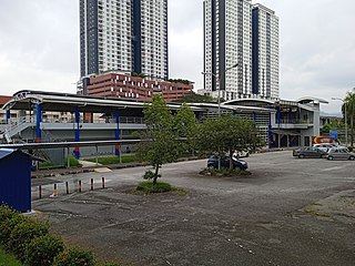
<span class="mw-page-title-main">Taman Melati LRT station</span>

Taman Melati LRT station is an elevated rapid transit station in northern Kuala Lumpur, Malaysia, part of the Kelana Jaya Line. The station was opened on 1 June 1999, as part of the line's second segment encompassing 12 stations between Masjid Jamek station and Terminal PUTRA and an underground line.

<span class="mw-page-title-main">Sentul Timur LRT station</span>

Sentul Timur LRT station is an elevated light rapid transit (LRT) station and serves as the terminal station for the Ampang Line and Sri Petaling Line. The station is located in Sentul, a suburb of Kuala Lumpur, which is surrounded by medium density low cost housing developments. Pangsapuri Melur is the nearest residential property to this station.

<span class="mw-page-title-main">Pandan Jaya LRT station</span>

Pandan Jaya LRT station is a Malaysian low-rise rapid transit station situated near and named after Pandan Jaya, in Ampang Jaya, Selangor. The station is part of the Ampang Line. The station was opened on December 16, 1996, as part of the first phase of the STAR system's opening, alongside 13 adjoining stations along the Sultan Ismail-Ampang route.

<span class="mw-page-title-main">Pandan Indah LRT station</span>

Pandan Indah LRT station is a Malaysian low-rise rapid transit station situated near and named after Pandan Indah, in Ampang Jaya, Selangor. The station of the Ampang Line, and was opened on December 16, 1996, as part of the first phase of the STAR system's opening, alongside 13 adjoining stations along the Sultan Ismail-Ampang route.

<span class="mw-page-title-main">Miharja LRT station</span>

Miharja LRT station is a Malaysian low-rise rapid transit station situated near and named after Taman Miharja. The station is part of the Ampang Line

<span class="mw-page-title-main">Cempaka LRT station</span>

Cempaka LRT station is a Malaysian low-rise rapid transit station situated near and named after the nearby Taman Cempaka, in Ampang Jaya, Selangor. The station is part of the Ampang Line, and was opened on December 16, 1996, as part of the first phase of the STAR system's opening, alongside 13 adjoining stations along the Sultan Ismail-Ampang route.

<span class="mw-page-title-main">Cahaya LRT station</span>

Cahaya LRT station is a Malaysian low-rise rapid transit station situated near and named after the nearby Taman Cahaya (Malay; English: Cahaya Estate, in Ampang Jaya, Selangor. The station is part of the Ampang Line, and was opened on December 16, 1996, as part of the first phase of the STAR system's opening, alongside 13 adjoining stations along the Sultan Ismail-Ampang route.

<span class="mw-page-title-main">Maluri station</span> LRT and MRT integrate in Kuala Lumpur, Malaysia

The Maluri station is an integrated light rapid transit (LRT) and mass rapid transit (MRT) located on the eastern fringe of Kuala Lumpur near and named after Taman Maluri, a residential housing estate. The station is located along Jalan Cheras opposite the AEON Taman Maluri shopping centre and Sunway Velocity Mall. The Kerayong River also runs beside the station.

Setiawangsa–Pantai Expressway (SPE), is partially-opened, under construction and one of the expressways in Klang Valley, Malaysia. The 29.8-kilometre (18.5 mi) expressway connects Taman Melati and Klang Gates from Kuala Lumpur Middle Ring Road 2 to Kerinchi Link near Pantai and University of Malaya. The alignment of Setiawangsa–Pantai Expressway will traverse north to south of Kuala Lumpur and will serve areas such as University Tunku Abdul Rahman, Wangsa Maju, Setiawangsa, Ampang, the Tun Razak Exchange & Bandar Malaysia development corridor and Kerinchi as well as providing a connection to Kuala Lumpur-Karak Experessay to the east coast. It was built and maintained by Ekovest Berhad. It is formerly known as DUKE Phase 3.

References

See also