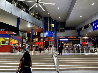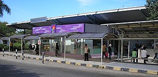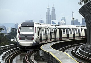
Rapid KL is a public transportation system owned by Prasarana Malaysia and operated by its subsidiaries Rapid Rail and Rapid Bus. The acronym stands for Rangkaian Pengangkutan Integrasi Deras Kuala Lumpur, which translates to Kuala Lumpur Rapid Integrated Transport Network in the Malay language. Rapid KL, with its 204.1 km (126.8 mi) of metro railway and 5.6 km (3.5 mi) of BRT carriageway, is part of the Klang Valley Integrated Transit System, operating throughout Kuala Lumpur and Selangor's satellite cities in the Klang Valley area.

Sentul is a suburb located within the northern part of the city centre in Kuala Lumpur, Malaysia, in the constituency of Batu. The vicinity of Sentul is sandwiched between Bukit Tunku and Titiwangsa.

Masjid Jamek LRT station is a rapid transit station in Kuala Lumpur, Malaysia. It is the interchange station between two of Rapid KL's light rapid transit (LRT) systems, namely the LRT Ampang and Sri Petaling Lines and the LRT Kelana Jaya Line. The station is one of only two stations integrating the LRT lines, the other being Putra Heights station. The station is situated near and named after the Masjid Jamek in central Kuala Lumpur.

Pudu LRT station is an elevated rapid transit station situated in Pudu, Kuala Lumpur, Malaysia. The station serves a single line that is shared by both the Ampang Line and Sri Petaling Line. The station was opened on 16 December 1996, as part of the first phase of the STAR LRT system's opening, alongside 13 adjoining stations along the Sultan Ismail-Ampang route.

Titiwangsa station is a rapid transit interchange station in Kuala Lumpur, Malaysia. The station is served by the LRT Ampang and Sri Petaling Lines, the KL Monorail Line and the MRT Putrajaya Line. The station allows seamless physical and fare integration between the four train lines.

Bandar Tasik Selatan station (BTS) is a major Malaysian interchange station located next to and named after Bandar Tasik Selatan, in Kuala Lumpur. The station serves as both a stop and an interchange for the KTM Komuter's Seremban Line, KTM ETS, the LRT Sri Petaling Line, and the Express Rail Link's KLIA Transit trains. BTS is integrated with the Terminal Bersepadu Selatan bus hub (TBS). BTS and TBS are developed as an intermodal transportation hub.
Transport in Greater Kuala Lumpur includes a road network, a railway network, airports, and other modes of public transport. Greater Kuala Lumpur is conterminous with the Klang Valley, an urban conglomeration consisting of the city of Kuala Lumpur, as well as surrounding towns and cities in the state of Selangor. The Klang Valley has the country's largest airport, the Kuala Lumpur International Airport (KLIA), as well as the country's largest intermodal transport hub and railway station, Kuala Lumpur Sentral.

Bandaraya LRT station is an elevated rapid transit station in central Kuala Lumpur, Malaysia. The station is on the common route shared by the Ampang Line and Sri Petaling Line. The station opened on 16 December 1996, as part of the first phase of the STAR system's opening, along with 13 adjoining stations along the Sultan Ismail to Ampang route.

Chan Sow Lin station is an integrated metro station in Pudu, Kuala Lumpur, Malaysia. The station serves as an interchange station between the LRT Sri Petaling Line, LRT Ampang Line and the MRT Putrajaya Line. The station consists of an at-grade station for the Ampang and Sri Petaling lines, and an underground station for the Putrajaya line. Both stations are connected by an elevated pedestrian walkway, allowing paid-to-paid integration.

Hang Tuah station, also known as BBCC - Hang Tuahstation due to the new transit hub, is an interchange station in the Pudu district of Kuala Lumpur, Malaysia, between the Ampang and Sri Petaling lines and the KL Monorail. Seamless physical and fare integration was achieved on 1 March 2012 when the "paid-up" or restricted areas of both the LRT and monorail stations, which previously operated as two separate stations, were linked up, allowing passengers to transfer without needing to buy new tickets for the first time since the monorail became operational in 2003.

PWTC LRT station is a light rail transit (LRT) station in Kuala Lumpur that is served by the Ampang Line and Sri Petaling Line. PWTC stands for "Putra World Trade Center", which was the former name of the World Trade Centre Kuala Lumpur. The World Trade Centre Kuala Lumpur is a convention and exhibition centre in Kuala Lumpur, Malaysia.
Sentul LRT station is an elevated light rapid transit (LRT) station operated by Rapid Rail located in Sentul, Kuala Lumpur, Malaysia. It is served by the Ampang line and Sri Petaling line. This station is situated next to two secondary schools, the Methodist Boys Secondary School Sentul and the Wesley Methodist School, three primary schools, and several medium-density, low-cost housing developments.

Sultan Ismail LRT station is a rapid transit station in Kuala Lumpur, Malaysia, operated by RapidKL served by the Ampang Line and Sri Petaling Line. This station was opened in 1996, along with 17 other LRT stations, as Phase 1 of the STAR LRT Line. It was the terminus of the Ampang-Sultan Ismail route before the extension to Sentul Timur. The Sultan Ismail LRT station stands between Sekolah Kebangsaan Lelaki Jalan Batu and Chung Kwok Primary School. The Malaysia's leading multinational conglomerate Sime Darby head office is opposite of this station. There is an artist impression of the station erected at SK Lelaki Jalan Batu.
Salak Selatan LRT station is a Malaysian low-rise light rapid transit (LRT) station situated near and named after the Kuala Lumpur township of Salak South. The station is part of the LRT Sri Petaling Line.

Miharja LRT station is a Malaysian low-rise rapid transit station situated near and named after Taman Miharja. The station is part of the Ampang Line

Ampang LRT station is a light rapid transit station operated by rapidKL serving the Ampang Line in Ampang, Selangor, Malaysia, just outside the eastern boundary of Kuala Lumpur. It is the eastern terminus for passenger services on the line. This station was opened in 1996, along with 17 other LRT stations.
Rapid Rail Sdn Bhd is the operator of the rapid transit (metro) system serving Kuala Lumpur and the Klang Valley area in Malaysia. A subsidiary of Prasarana Malaysia, it is the sole operator of five rapid transit lines which collectively form the Rapid KL rapid transit system. The system currently consists of three light rapid transit (LRT) lines, two mass rapid transit (MRT) lines and a monorail line, with another MRT and LRT line currently under construction.

The LRT Ampang Line and the LRT Sri Petaling Line are medium-capacity light rapid transit (LRT) lines in the Klang Valley, Malaysia. The combined network comprises 45.1 kilometres (28.0 mi) of tracks with 36 stations and was the first railway in Malaysia to use standard-gauge track and semi-automated trains. The lines are operated as part of the Rapid KL system by Rapid Rail, a subsidiary of Prasarana Malaysia.

The Klang Valley Integrated Transit System is an integrated transport network that primarily serves the area of Klang Valley and Greater Kuala Lumpur. The system commenced operations in August 1995 with the introduction of commuter rail service on the existing rail between Kuala Lumpur and Rawang. The system have since expanded and currently consists of 11 fully operating rail lines in a radial formation; two commuter rail lines, six rapid transit lines, one bus rapid transit line and two airport rail links to the Kuala Lumpur International Airport's (KLIA) Terminal 1 and Terminal 2, and one temperarily suspended airport rail link to the Sultan Abdul Aziz Shah Airport. The system encompasses 528.4 kilometres (328.3 mi) of grade-separated railway with 197 operational stations.


