This article needs additional citations for verification .(January 2017) |
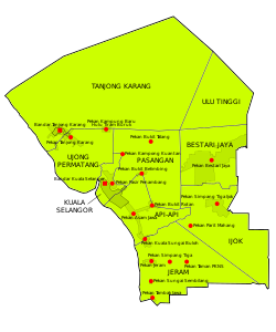
Jeram is a town and mukim in Kuala Selangor District, Selangor, Malaysia.
It is about halfway between Kapar and Kuala Selangor, on Highway 5. [1]
Jugra is a mukim, historical town and former royal town in Kuala Langat District, Selangor, Malaysia. It is separated from Pulau Carey by the Langat River. The town is administered by the Zone 16 of the Kuala Langat Municipal Council.
Kuala Selangor is a town in northwestern Selangor, Malaysia. It is the largest town and administrative centre of the coterminous Kuala Selangor District.
Ampang, or Ampang Hilir, is a ward and city district, in the eastern part of Kuala Lumpur (KL) in the Titiwangsa constituency. Its area in Kuala Lumpur can be identified as being along the Ampang Road and Ampang Hilir.
Federal Route 55 or Jalan Kuala Kubu Bharu–Teranum–Raub is a 62-km federal road connecting the states of Selangor and Pahang in Malaysia. It is the first federal road ever constructed in Pahang. The road connects Kuala Kubu Bharu, Selangor to Teranum near Raub in Pahang where it meets Federal Route 218. It is the main access route to Fraser's Hill.
Bandar Sri Damansara is a residential township in Petaling District, Selangor, Malaysia. The township is divided into two sections, SD1-SD5 in the north and SD7-SD15 in the south which are separated by Kuala Selangor-Kepong Highway. It is adjacent to Kepong and Sungai Buloh. The township consists of mixed development of commercial and residential properties. It was previously developed by Land and General Berhad and currently by TA Global.
Dengkil is a town and mukim in Sepang District, southern Selangor, Malaysia.
Bukit Nanas, meaning "Pineapple Hill", is a small hill in Kuala Lumpur, Malaysia. With a height of 94 meter above sea level, it contains the only virgin tropical rain forest left in the heart of Kuala Lumpur. The Bukit Nanas Forest Reserve is located here, and is open to the public. There are jungle trails, a visitors centre, and a forestry museum.
Morib is a mukim in Kuala Langat District, Selangor, Malaysia, under the administration of Zone 18 of Kuala Langat Municipal Council. Morib Beach is a quiet seaside tourist attraction. It was one of the first landing points on the west coast for the British and Indian Army liberation forces during end of World War II in 1945. It is a small but suitable beach for swimming. Morib is a state constituency in Selangor, Malaysia, that has been represented in the Selangor State Legislative Assembly since 1959.
Telok Panglima Garang is a mukim in Kuala Langat District, Selangor, Malaysia. The Telok Panglima Garang Free Trade Zone (FTZ) is located here. The town is administered by the Zone 4, 5 and 8 of the Kuala Langat Municipal Council.
The Selangor River is a major river in Selangor, Malaysia. It runs from Kuala Kubu Bharu in the east and empties into the Straits of Malacca at Kuala Selangor in the west.
Universiti Kuala Lumpur (UniKL) is a multi-campus technical university with its main campus based in Kuala Lumpur, Malaysia. Rated as a Tier-5 "Excellent University" by the Ministry of Higher Education Malaysia in 2009, 2011, 2013 and awarded Putra Brand Award in 2016. UniKL has 14 institutes spread across 12 campuses throughout Malaysia in Kuala Lumpur, Gombak, Cheras, Bangi, Kajang, Sepang, Taboh Naning, Pasir Gudang, Ipoh, Lumut and Kulim.
The Cathedral of St. Mary the Virgin or St. Mary's Cathedral is the cathedral of the Diocese of West Malaysia of the Anglican Church of the Province of South East Asia, located in Kuala Lumpur, Malaysia. It is the Episcopal see of the Anglican Bishop of West Malaysia and the mother church of the diocese.
Bestari Jaya(formerly Batang Berjuntai) is a town and a mukim in Kuala Selangor District, Selangor, Malaysia. It is 40 km NW from Kuala Lumpur.
The Padang Jawa Komuter station is a commuter train halt located in Padang Jawa, Selangor, Malaysia. It is served by the Port Klang Line. Padang Jawa is a village between the towns Shah Alam and Klang. Universiti Teknologi MARA main campus is located around 2 kilometers from the halt.
Pandamaran is a town and a state constituency in Klang District, Selangor, Malaysia. It is adjacent to Port Klang and close to Tengku Ampuan Rahimah Hospital as well as Bandar Bukit Tinggi. Pandamaran is essentially a Chinese New Village area, it is served by excellent road connections and is one of the major industrial zones in the royal town of Klang.
Damansara is a suburb in Petaling Jaya, a mukim in Petaling District, as well as a parliamentary constituency in Selangor, Malaysia. It is named after the Damansara River which flows nearby. It is one of the most densely populated areas in Malaysia. According to the 2000 Census of Malaysia, it was the second-largest district subdivision in Malaysia in terms of population with 453,420 residents.
The Sultan Salahuddin Abdul Aziz Shah Bridge is a main bridge in Kuala Selangor District, Selangor, Malaysia crossing Selangor River.
The Istana Bandar is a historical palace in Jugra, Kuala Langat District, Selangor, Malaysia.
The Klang Gates Quartz Ridge is a quartz dyke that runs through northeast of Kuala Lumpur and the state of Selangor, Malaysia within Bukit Lagong-Kanching-Klang Gates region. With the dimension of more than 14 km long and 200 m wide, it is the longest quartz formation in the world. The other major quartz vein in Kuala Lumpur is along Kajang-Cheras road, which is about 8 km long, however the Klang Gates Quartz Ridge is one-of-its-kind because it has four types of quartz formation. The area has five endemic plants species among 265 species, found nowhere else in the world. A rare animal, the serow is found here as well.
The Maybank Championship was a professional golf tournament, co-sanctioned by the Asian Tour and the European Tour, that was played annually in Malaysia. The tournament was founded in 2016 by sponsors Maybank, who had previously sponsored the Malaysian Open, with the inaugural tournament played from 18–21 February at Royal Selangor Golf Club in Kuala Lumpur. It had a purse of US$3,000,000.
Coordinates: 4°23′09.8″N101°09′26.8″E / 4.386056°N 101.157444°E