History
The opening of Kundang is strongly related to tin ore. At the end of the 19th century, tin ore was found in the Kundang River. This discovery attracts many Chinese immigrants to the place and the Kundang settlement was established. The Kanching territory which is in the Rawang district, have started tin mining operations in the 1840s is one of the oldest tin mining area in Selangor. After that, areas around Rawang town like Kundang and Kuang have initially started tin mining activities respectively. New settlements are also established due to tin mining. Some people said that if there is tin ore, there is Hakka people. Ka Yin and Kochow Association in Kundang proved that these two clans is the earliest Chinese immigrants settled there. Aside of the Ka Yin clan who forms the majority of residents in Kundang, another bigger clans comes from the Hui Zhou, while the minority is from the He Po clan. To boost the industry of tin mining, British colonizers had developed the railway system.
In 1915, the first railway track that connects Kundang and Kuang together with Batu Arang was built. Kundang also had a railway station due to this railway construction. After the decline of tin mining, the railway system also ceased its operation. The Kundang railway station was demolished in 1970. Abandoned railway tracks has become a proof to the history. The Kundang Tin company is the largest British-owned mining company in Kundang at the beginning of the 20th century. In the year of 1924, Kuala Lumpur Rubber company also started tin mining operations in Kundang. The company name soon changed to Kuala Lumpur Kepong Berhad. Meanwhile, Lee Li Sheng and Lee Jiu Ru, the Chinese tin tycoon from the Ka Yin descendant, who is one of the tin mining operators in Kundang. They had built the Gen Yen school in 1934 to appreciate the contribution of tin mining workers from the Hakka descendants in Kundang. In circa 1920, British had encouraged the residents to plant rubber in mass scale. The residents have been awarded land plots to plant rubber. Kundang Estate was the biggest rubber plantation estate in Kundang in that time (the area beside the Kundang Industrial Area). In the Japanese occupation from 1942 to 1945, Kundang paralyses due to war. This place was also one of the MPAJA headquarters.
This chaotic atmosphere strikes back in 1948. To break the help from being received by the MCP, British had gathered all residents who live scattered outside the Kundang area and effectively established the Kundang New Village. The Kundang Old Town is a part of Kundang New Village. A row of old shoplots that still standing until today differentiates them with the new town. According to oral stories, there is a hundred year old well in Kundang Old Town. But due to low pressure water, water rationing is always carried out in Kundang. Therefore, many of Kundang residents still using this well until today. The Kundang New Village has 200 families with approximately 1500 people when it was first established. After 30 years, the differences of total residents is not really significant. The total residents in 1954 is 1525 people and 1565 in 1970. This reflects migration of residents. But now the condition is far better, with the 5800 increase in 1995.
The village estimated to have 7000 residents before the 1980s, when the decline of tin mining and rubber made Kundang became deserted again. To find new sources of living, residents had started to plant papaya in land plots, hundreds of acres at the Kundang New Village border. In short time, hundreds of land turned into papaya plantations. In that time, Kundang New Village is called 'Selangor's Papaya Village'. This good condition did not last long. One of the reason is, the type of papaya planted there is from ordinary genes. It makes the selling prices low. Added with the price application by middleman makes those papaya can be sold at 8 cents per catty (1 catty = 600 grams). One more problem is tree diseases. Residents started to leave papaya plantation sector slowly and gradually in the 1990s. Now the history of the papaya plantation on its heyday at Kundang New Village is just a memory.
Kundang Industrial Park, a joint project of IGB and Selangor Economic Development Corporation, launched in 1992. The industrial park cover a total of 400 hectares with 180 hectares developed into industrial lots. It was expected to be completed in five years. [1] Palm-Oleo Sdn Bhd opened its manufacturing factory at Kundang Industrial Park in April 1994. [2]
Selangor, also known by the Arabic honorific Darul Ehsan, or "Abode of Sincerity", is one of the 13 states of Malaysia. It is on the west coast of Peninsular Malaysia and is bordered by Perak to the north, Pahang to the east, Negeri Sembilan to the south, and the Strait of Malacca to the west. Selangor surrounds the federal territories of Kuala Lumpur and Putrajaya, both of which were previously part of it. Selangor has diverse tropical rainforests and an equatorial climate. The state's mountain ranges belong to the Titiwangsa Mountains, which is part of the Tenasserim Hills that covers southern Myanmar, southern Thailand and Peninsular Malaysia, with Mount Semangkok as the highest point in the state.

Klang or Kelang, officially Royal City of Klang, is a city, royal city and former capital of the state of Selangor, Malaysia. It is located within the Klang District. It was the civil capital of Selangor in an earlier era prior to the emergence of Kuala Lumpur and the current capital, Shah Alam. Port of Port Klang, which is located in the Klang District, is the 12th busiest transshipment port and the 12th busiest container port in the world.

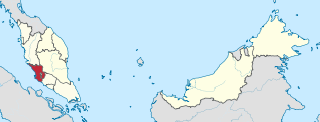
Rawang is a town and a mukim in Gombak District, Selangor, Malaysia, about 23 km northwest of city centre Kuala Lumpur.

The Gombak District is an administrative district located in the state of Selangor, Malaysia. The district was created on February 1, 1974, the same day when Kuala Lumpur was declared a Federal Territory. Until 1997, Rawang was the district capital; the capital has been moved to Bandar Baru Selayang. Gombak borders Kuala Lumpur to the southeast and the Genting Highlands to the east. Both Gombak and Kuala Lumpur, along with some other districts in Selangor, are situated within the Klang Valley. Other localities in Gombak district include Batu Arang, Kuang, Rawang, Kundang, Gombak Town, Selayang, Batu Caves and Hulu Kelang.

Sungai Buloh, or Sungei Buloh, is a town, a mukim (commune) and a parliamentary constituency in the northern part of Petaling District, Selangor, Malaysia. The name itself means bamboo river in the Malay language. It is located 16 km NW of downtown Kuala Lumpur and 8 km north of the Subang Airport, along the Kuala Selangor highway.

Puchong is a major town and a parliamentary constituency in the Petaling District, in the state of Selangor, Malaysia. Bordering Kuala Lumpur, it is part of the Greater Kuala Lumpur area. It is bordered by Petaling Jaya in the north, Subang Jaya in the west, Cyberjaya and Putrajaya in the south, and Seri Kembangan in the east.

Setapak is a town and mukim straddling both norteastern Kuala Lumpur and Gombak District of Selangor, Malaysia.

Batu Arang is a town in Gombak District, Selangor, Malaysia, that is located about 50 km from the capital Kuala Lumpur. Coal was first discovered in the region in 1908, when British authorities found large deposits of coal reserves that could be commercially viable and fuel a railway system. The town was established when the British started mining operations. In 1915, a railway system linking Batu Arang and Kuang was built to transport coal to the rest of the country. As coal output and demand increased, rail services to and from Kuala Lumpur expanded. The demand for coal from Batu Arang skyrocketed due to the First World War, which led to a reduction of coal imports. The local coal was frequently sold to the railway companies, power stations, tin mines, dredges, and end customers.

Kuang is a town in Gombak District, Selangor, Malaysia. Its main importance in older times was the starting of the railway branch to Batu Arang from the mainline of Malayan Railways. Today, Kuang's main industry is cement distribution for the CIMA Company. There is a successful HS Nada cow farm at Kampung Gombak.

Balakong; Chinese: 無拉港) or Cheras South; Chinese: 蕉賴南區) is a township in Hulu Langat District, Selangor, Malaysia. Located to the southeast of Greater Kuala Lumpur, the township consists mainly of residential condominiums, office complexes and factories. Notable landmarks in Balakong include AEON Mall Cheras Selatan and Sin Ann Meow Temple (星安庙).

Ampang Jaya, more commonly known as just Ampang, is a town, a mukim and a parliamentary constituency straddling parts of the Hulu Langat District and Gombak District, in eastern Selangor, Malaysia. It is located just outside the eastern border of Kuala Lumpur Federal Territory.
The geography of Kuala Lumpur, Malaysia is characterized by a huge valley — known as the Klang Valley — bordered by the Titiwangsa Mountains in the east, several minor ranges in the north and the south and the Malacca Straits in the west. The name Kuala Lumpur literally means muddy confluence; Kuala Lumpur is located at the confluence of the Klang and Gombak Rivers, facing the Malacca Straits.

The Kuala Lumpur–Kuala Selangor ExpresswayKuala Lumpur–Kuala Selangor Expressway, KLS(formerly Ijok–Templer Park Highway, LATAR) or sometimes called LATAR Expressway, is an expressway in Selangor, Malaysia. It is part of the Kuala Lumpur Outer Ring Road. The 32 km (20 mi) expressway connects Ijok near Kuala Selangor to Templer's Park near Rawang and not Kuala Lumpur as its name suggests – consequently, motorists will need to travel another 20 km to Kuala Lumpur via Kuala Lumpur–Rawang Highway. Kuala Lumpur–Kuala Selangor Expressway is the fourth east–west-oriented expressway in the Klang Valley after the Federal Highway, the New Klang Valley Expressway (NKVE) and the Shah Alam Expressway.
Tasik Biru Seri Kundang is a recreational lake located at Kampung Melayu Sri Kundang, Rawang, Selangor, Malaysia, a village near to Sungai Buloh. It is an ex-mining lake that used to be developed long time ago during the British colonial time. During its olden days, the lake was used to be the biggest mining area in Rawang district, and one of the biggest in Selangor as well. It is about 25 km to the north from Kuala Lumpur.
Kota Puteri is a township in Gombak District, Selangor, Malaysia, developed by the PKNS. The town is alternately known as Bandar Baru Batu Arang. It is divided into 12 sections.

Bandar Tasik Puteri is a township area near Batu Arang, Selangor, Malaysia.
Saujana Rawang is a township in Gombak District, Selangor, Malaysia. It is a 345 acres (140 ha) self-contained township development by Glomac Berhad that was originally launched in 2006.
The following is an alphabetical list of articles related to Selangor.


