
Kajang is a town in both Hulu Langat District and Sepang District, Selangor, Malaysia. Kajang, along with much of Hulu Langat District, is governed by the Kajang Municipal Council. Some parts of Kajang such as Seksyen 12 Bandar Baru Bangi, Kampung Sungai Merab, Desa Pinggiran Putra and Kampung Dato Abu Bakar Baginda are located in northeast Dengkil, Sepang District and is governed by the Sepang Municipal Council. Kajang town is located on the eastern banks of the Langat River. It is surrounded by Cheras, Semenyih, Bangi, Putrajaya and Serdang.
Selangor, also known by its Arabic honorific Darul Ehsan, or "Abode of Sincerity", is one of the 13 states of Malaysia. It is on the west coast of Peninsular Malaysia and is bordered by Perak to the north, Pahang to the east, Negeri Sembilan to the south, and the Strait of Malacca to the west. Selangor surrounds the federal territories of Kuala Lumpur and Putrajaya, both of which were previously part of it. Selangor has diverse tropical rainforests and an equatorial climate. The state's mountain ranges belong to the Titiwangsa Mountains, which is part of the Tenasserim Hills that covers southern Myanmar, southern Thailand and Peninsular Malaysia, with Mount Semangkok as the highest point in the state.

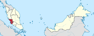
The Sepang District is a district located in the southern part of the state of Selangor in Malaysia. Sepang District covers an area of around 600 square kilometres, and had a population of 190,889 in the 2010 Census.

The Petaling District is a district located in the heart of Selangor in Malaysia. Petaling is not to be confused with the city of Petaling Jaya located in it, nor the mukim of Petaling under Subang Jaya City. The district office is located in Subang.

The Batu Pahat District is a district in the state of Johor, Malaysia. It lies southeast of Muar, southwest of Kluang, northwest of Pontian, south of Segamat and Tangkak District. The capital of the district is Bandar Penggaram.

Hulu Langat District is a district of Malaysia located in the southeastern corner of Selangor, between Kuala Lumpur and Negeri Sembilan. It is bordered by the state of Pahang to the east and north, Gombak district to the north-west, Federal Territory of Kuala Lumpur and Petaling district to the west, Sepang district to the south-west, and state of Negeri Sembilan to the south.

Hulu Selangor is a district in Selangor, Malaysia. It contains the towns of Serendah, Batang Kali and Kuala Kubu Bharu. Its principal town is Kuala Kubu Bharu. The district is located in the northeastern part of Selangor and borders the state of Perak to the north, Pahang to the east, Sabak Bernam district to the northwest, Kuala Selangor district to its southwest and Gombak district to the south. Selangor River sources from this area, hence giving the district's name.

The Gombak District is an administrative district located in the state of Selangor, Malaysia. The district was created on February 1, 1974, the same day when Kuala Lumpur was declared a Federal Territory. Until 1997, Rawang was the district capital; the capital has been moved to Bandar Baru Selayang. Gombak borders Kuala Lumpur to the southeast and the Genting Highlands to the east. Both Gombak and Kuala Lumpur, along with some other districts in Selangor, are situated within the Klang Valley. Other localities in Gombak district include Batu Arang, Kuang, Rawang, Kundang, Gombak Town, Selayang, Batu Caves and Hulu Kelang.

The Sabak Bernam District is a district and a parliamentary constituency in north-western Selangor, Malaysia. It covers an area of 997 square kilometres, and had a population of 103,153 at the 2010 Census. It is situated at the northwestern corner of Selangor. It is bordered by the state of Perak to the north, the district of Hulu Selangor to the east, the district of Kuala Selangor to the south, and the Straits of Malacca to the west. Bernam River forms its border with Perak. Towns in Sabak Bernam include Sabak, Sungai Besar and Sekinchan. This area is also famous for its residents of Javanese descent.
The Kuala Langat District is a district of Selangor, Malaysia. It is situated in the southwestern part of Selangor. It covers an area of 858 square kilometres, and had a population of 307,787 at the 2020 Census. It is bordered by the districts of Klang and Petaling to the north and Sepang to the east. The Strait of Malacca forms its western border.

The Jerantut District is a district in north-eastern Pahang, Malaysia. Jerantut is home to the National Park.

Setapak is a town and mukim straddling both norteastern Kuala Lumpur and Gombak District of Selangor, Malaysia.

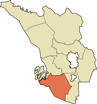
Dengkil is a town and mukim in Sepang District, southern Selangor, Malaysia.

Salak Tinggi is a town in Sepang District, Selangor, Malaysia. Located about 9 km north of the Kuala Lumpur International Airport, it is the seat of the Sepang district's administration.

The Seremban District is one of 7 districts in Negeri Sembilan, Malaysia. This is where the capital of Negeri Sembilan, Seremban is located.

Batu Caves is a mukim and town in Gombak District, Selangor, Malaysia. Named after the limestone caves and Hindu shrine Batu Caves, the town is experiencing an increase in residences due to a housing boom in the center of the city.

Greater Kuala Lumpur is the geographical term that determines the boundaries of metropolitan Kuala Lumpur in Malaysia. Though similar to the term "Klang Valley", there remains a variation between the two. The metropolitan area covers 5,194.72 square km of land.

The Klang District is a district in Selangor, Malaysia. It is located in the western part of Selangor. It borders the Kuala Selangor District to the north, Petaling to the east, Kuala Langat district to the south and Malacca Straits to the west. The district was further divided into two mukims which is Klang and Kapar that covers 626.78 square km of land with 53.75 km of coastline.

The Kuala Selangor District is a district in Selangor, Malaysia. It has a total landmass of 1,194.52 square kilometres separated by Selangor River into two division, Tanjung Karang and Kuala Selangor. The district boundary is shared with Sabak Bernam at the north, Hulu Selangor and Gombak at the west, Petaling at the southwest and Klang at the south.


