Machang District

Last updated
Machang District
Mache
Jajahan Machang
Other transcription(s)
   Jawi ماچڠ
   Chinese 马樟县
   Tamil மாச்சாங்
Flag of Machang, Kelantan.svg
Machang highlighted in Kelantan, Malaysia.svg
Location of Machang District in Kelantan
Machang District
Malaysia location map.svg
Red pog.svg
Machang District
Location of Machang District in Malaysia
Coordinates: 5°45′N102°15′E / 5.750°N 102.250°E / 5.750; 102.250 Coordinates: 5°45′N102°15′E / 5.750°N 102.250°E / 5.750; 102.250
Country Flag of Malaysia.svg  Malaysia
State Flag of Kelantan.svg  Kelantan
As a subdistrict1949
As a district1952
Seat Machang
Local area government(s) Machang District Council
Government
  District officerNik Mohd Hasanuddin Bin Nik Hussain [1]
  Administrative office Pejabat Tanah dan Jajahan Machang
Area
[2]
  Total526 km2 (203 sq mi)
Population
 (2021) [3]
  Total112,900
  Density215/km2 (560/sq mi)
Time zone UTC+8 (MST)
  Summer (DST) UTC+8 (Not observed)
Postcode
18500
Calling code +6-09
Vehicle registration plates D

Machang is one of the ten districts in the state of Kelantan, Malaysia. It is situated at the centre of the state, bordering with Kelantanese territories of Kota Bharu to the north, Pasir Puteh to the east,Terengganu State to the southeast, Tanah Merah to the west and Kuala Krai to the south. Its major town and administrative centre is Machang town.

Contents

History

Previously part of Ulu Kelantan, [4] around 1949, Machang was delineated as an autonomous sub-district of Kelantan. Owing to its rapid pace of development and active economic sector, Machang was upgraded as a full District on January 1, 1952. [5] The territory is still largely agrarian, home to a lot of paddy fields, palm and rubber plantations.

Attractions

Among the attractions that get frequented a lot in Machang District are the hot springs that are situated in Kampung Rengas Tok Bok, Hutan Lipur Bukit Bakar, [6] Air Terjun Jeram Linang [7] and Hutan Lipur Cabang Tongkat.

Educational Institution

The district is the host for the Universiti Teknologi Mara (Machang Branch), 9 national secondary schools, 1 fully residential school, 3 State-Funded Islamic religious school and 20 national primary schools which include a Chinese vernacular national type primary school.

University

  1. Universiti Teknologi Mara Machang (UiTM)

Secondary Education

National Schools

  1. Sekolah Menengah Kebangsaan Machang
  2. Sekolah Menengah Kebangsaan Hamzah 1
  3. Sekolah Menengah Kebangsaan Hamzah 2
  4. Sekolah Menengah Kebangsaan Bandar Machang
  5. Sekolah Menengah Kebangsaan Abdul Samad
  6. Sekolah Menengah Kebangsan Agama Wataniah Machang
  7. Sekolah Menengah Kebangsaan Sri Intan
  8. Sekolah Menengah Kebangsaan Temangan
  9. Sekolah Menengah Kebangsaan Pangkal Meleret

Fully Residential School

  1. Sekolah Menengah Sains Machang

State Funded Islamic Religious School

  1. Maahad Tahfiz Al Quran Wal Qiraat
  2. Maahad Syamsul Maarif Lelaki
  3. Maahad Syamsul Maarif Perempuan

Primary Education

National Schools

  1. Sekolah Kebangsaan Ayer Merah
  2. Sekolah Kebangsaan Bandar
  3. Sekolah Kebangsaan Bukit Tiu
  4. Sekolah Kebangsaan Belukar
  5. Sekolah Kebangsaan Dewan Besar
  6. Sekolah Kebangsaan Hamzah (1)
  7. Sekolah Kebangsaan Hamzah (2)
  8. Sekolah Kebangsaan Kampung Pek
  9. Sekolah Kebangsaan Labok
  10. Sekolah Kebangsaan Machang (1)
  11. Sekolah Kebangsaan Machang (2)
  12. Sekolah Kebangsaan Mata Ayer
  13. Sekolah Kebangsaan Pulai Chondong
  14. Sekolah Kebangsaan Pak Roman
  15. Sekolah Kebangsaan Pangkal Gong
  16. Sekolah Kebangsaan Pangkal Meleret
  17. Sekolah Kebangsaan Pangkal Nering
  18. Sekolah Kebangsaan Pangkal Jenereh
  19. Sekolah Kebangsaan Pulai Chondong
  20. Sekolah Kebangsaan Temangan
  21. Sekolah Kebangsaan Tok Bok

National School (Chinese Vernacular)

  1. Sekolah Jenis Kebangsaan (C) Pei Hwa

Demographics

Historical population
YearPop.±%
1991 71,584    
2000 77,762+8.6%
2010 89,118+14.6%
2020 110,008+23.4%
Source: [8]
Map of Machang District Map of Machang District, Kelantan.svg
Map of Machang District

As of 2010, Machang has a population of 92,149 people. [3]

Ranking Population of Jajahan Machang.

RankDaerah/MukimPopulation 2000
1 Ulu Sat 26,800
2 Pulai Chondong 12,661
3 Labok 12,136
4 Panyit 10,330
5 Pangkal Meleret 10,225
6 Temangan 5,608

Federal Parliament and State Assembly Seats


List of LMS district representatives in the Federal Parliament (Dewan Rakyat)

ParliamentSeat NameMember of ParliamentParty
P29 Machang Wan Ahmad Fayhsal Wan Ahmad KamalPerikatan Nasional (PPBM)


List of LMS district representatives in the State Legislative Assembly of Kelantan

ParliamentStateSeat NameState AssemblymanParty
P29N33 Pulai Chondong Azhar Salleh Perikatan Nasional (PAS)
P29N34 Temangan Mohamed Fadzli Hassan Perikatan Nasional (PAS)
P29N35 Kemuning Mohd Roseli Ismail Perikatan Nasional (PAS)

Transportation

Highways 4 and 8 intersect in Machang.

KTM Intercity does not serve Machang town; however there is a railway halt in Temangan town about 10 km from Machang town centre. The halt is the only railway station operating in the Machang constituency.

Related Research Articles

<span class="mw-page-title-main">Kedah</span> State of Malaysia

Kedah, also known by its honorific Darul Aman and historically as Queda, is a state of Malaysia, located in the northwestern part of Peninsular Malaysia. The state covers a total area of over 9,000 km2, and it consists of the mainland and the Langkawi islands. The mainland has a relatively flat terrain, which is used to grow rice, while Langkawi is an archipelago, most of which are uninhabited islands.

<span class="mw-page-title-main">Jeli District</span> District of Malaysia in Kelantan

The Jeli District is a district and a parliamentary constituency in western Kelantan, Malaysia. As of 2010, the district's population is estimated to be 42,150. Jeli is administered by the Jeli District Council. Jeli is bordered by the state of Perak to the west, the Thai district of Waeng to the north, Tanah Merah district to the north east and Kuala Krai district to the south east.

<span class="mw-page-title-main">Batang Kali</span> Town in Malaysia

Batang Kali is a town and mukim in Hulu Selangor District, Selangor, Malaysia.

<span class="mw-page-title-main">Gua Musang District</span> District of Malaysia in Kelantan

Gua Musang is a town, district and parliamentary constituency in southern Kelantan, Malaysia. It is the largest district in Kelantan. Gua Musang is administered by the Gua Musang District Council. Gua Musang district is bordered by the state of Pahang to the south, Terengganu to the east, Perak to the west and the Kelantanese districts of Kuala Krai and Jeli to the north. It is a small railway town about 140 km south of state capital Kota Bharu. Gua Musang is represented by Tengku Razaleigh Hamzah in the Dewan Rakyat. The town lies on the KTM East Coast Line, from Tumpat, near the border with Thailand, to Gemas, Negeri Sembilan.

<span class="mw-page-title-main">Pengkalan Hulu</span> Town in Perak, Malaysia

Pengkalan Hulu, formerly known as Kroh or Keroh, is a town and a mukim in Hulu Perak District, Perak, Malaysia, bordering Thailand and Kedah. The nearest town on the Thailand side is Betong in Yala province.

Bandar Tun Razak, Jengka formerly known as Bandar Pusat Jengka or Jengka Town Centre is an agricultural town in Maran District, Pahang, Malaysia. Bandar Tun Razak is the centre of the Jengka Triangle which is known as FELDA Jengka. The Jengka Triangle, which is the largest FELDA settlement in Malaysia, is one of the successful of the Malaysian government's projects to eradicate poverty among its citizens.

<span class="mw-page-title-main">Besut District</span> District of Malaysia in Terengganu

Besut is a district in Terengganu, Malaysia. It is bordered by the state of Kelantan to the north and west and the South China Sea to the east. It is the northern gateway to Terengganu. Kampung Raja is the district capital, though Jerteh is more developed. Another major town is the fishing port of Kuala Besut. There are other small towns and villages such as Jabi, Apal, Pasir Akar and Tembila.

<span class="mw-page-title-main">Pasir Puteh District</span> District of Malaysia in Kelantan

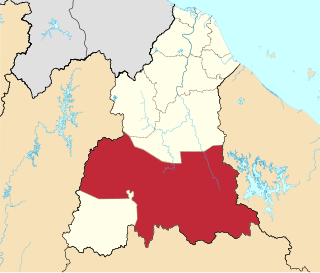
Pasir Puteh District is a district (jajahan) in Kelantan, Malaysia. The town of Pasir Putih is situated on the bank of Semerak River, about 30 kilometers to the south of Kota Bharu. Pasir Puteh district borders Terengganu to its south-east.

<span class="mw-page-title-main">Bachok District</span> District of Malaysia in Kelantan

Bachok District is an administrative division of Kelantan, Malaysia. It is located approximately 25 km east of Kota Bharu.

<span class="mw-page-title-main">Kuala Krai District</span> District of Malaysia in Kelantan

Kuala Krai District is a district (jajahan) in Kelantan, Malaysia. Historically, it was known as Kuala Lebir.

<span class="mw-page-title-main">Tanah Merah District</span> District of Malaysia in Kelantan

Tanah Merah District is a district (jajahan) in the state of Kelantan in northeast Malaysia. The urban area of Tanah Merah is situated along the Kelantan River. It is bordered by Pasir Mas District in the north, Machang District to the East, Kuala Krai District to the South East, Jeli District to the South West and Thailand in the West.

<span class="mw-page-title-main">Kota Setar District</span> District of Malaysia in Kedah

The Kota Setar District is a district in Kedah, Malaysia where the state capital Alor Star is situated.

Batu Caves is a mukim and town in Gombak District, Selangor, Malaysia. The town is experiencing an increase in residences due to a housing boom in the center of the city.

<span class="mw-page-title-main">Machang (town)</span> Town in Kelantan darul Naim, Malaysia

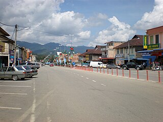
Machang is a town in Machang District, Kelantan, Malaysia. It is a home to one of the main campuses of Universiti Teknologi MARA.

<span class="mw-page-title-main">Pasir Mas District</span> District of Malaysia in Kelantan

Pasir Mas District is a district (jajahan) in Kelantan, Malaysia. The district covers an area of 614.15 square kilometers and is bordered by the districts of Tumpat District to the north, Tanah Merah District to the south, Kota Bharu District to the east, and the Thai district of Su-ngai Kolok to the west.

<span class="mw-page-title-main">Nik Mohd. Amar Nik Abdullah</span> Malaysian Politician (born 1959)

Yang Berhormat Dato' Haji Nik Mohd Amar bin Abdullah is a Malaysian politician, who currently serves as the DeputyMenteri Besar of Kelantan and the councilor of the Kelantan State Executive Council.

References

  1. "Pejabat Tanah Dan Jajahan Machang - Perutusan Ketua Jajahan Machang". www.ptjm.kelantan.gov.my. Retrieved 2022-09-09.
  2. "Laman Web Rasmi Pejabat Tanah Dan Jajahan Machang - Sejarah". www.ptjm.kelantan.gov.my. Archived from the original on 2018-10-18. Retrieved 2016-10-17.
  3. 1 2 "Population Distribution and Basic Demographic Characteristics, 2010" (PDF). Department of Statistics, Malaysia. Archived from the original (PDF) on 22 May 2014. Retrieved 19 April 2012.
  4. "Raremaps.com" . Retrieved 10 January 2017.
  5. "Sejarah". Laman Web Rasmi Pejabat Tanah dan Jajahan Machang. Archived from the original on 18 October 2018. Retrieved 17 October 2016.
  6. Hutan Lipur Bukit Bakar
  7. Air Terjun Jeram Linang
  8. "Key Findings Population and Housing Census of Malaysia, 2020" (in Malay and English). Department of Statistics, Malaysia.