Batu Pahat District

Last updated

Batu Pahat District
Flag of Malaysia.svg District of Malaysia
Daerah Batu Pahat
Other transcription(s)
   Jawi باتو ڤاهت
   Chinese 峇株巴辖县
   Tamil பத்து பஹாட்
Flag of Batu Pahat, Johor.svg
Logo Baharu Majlis Perbandaran Batu Pahat.png
Batu Pahat highlighted in Johor, Malaysia.svg
Location of Batu Pahat District in Johor
Batu Pahat District
Malaysia location map with districts.svg
Red pog.svg
Batu Pahat District
Location of Batu Pahat District in Malaysia
Coordinates: 1°55′N103°0′E / 1.917°N 103.000°E / 1.917; 103.000
CountryMalaysia
State Johor
Seat Batu Pahat
Local area government(s) Batu Pahat Municipal Council
(West)
Yong Peng District Council
(East)
Government
  District officerHaji Zulkiflee bin Haji Abbas
Area
[1]
  Total1,872.58 km2 (723.01 sq mi)
Population
 (2020) [2]
  Total495,338
  Density260/km2 (690/sq mi)
Time zone UTC+8 (MST)
  Summer (DST) UTC+8 (Not observed)
Postcode
83xxx and 86xxx
Calling code +6-07-42 to +6-07-46
Vehicle registration plates J

The Batu Pahat District is a district in the state of Johor, Malaysia. It lies southeast of Muar, southwest of Kluang, northwest of Pontian, south of Segamat and Tangkak District. The capital of the district is Bandar Penggaram.

Contents

Geography

Batu Pahat River BatuPahatRiver.jpg
Batu Pahat River

The capital of the district Bandar Penggaram, Batu Pahat is located at 1°51′N102°56′E / 1.850°N 102.933°E / 1.850; 102.933 . It is 239 km (150 miles) from Kuala Lumpur. The next nearest town is Muar which is 50 km (30 miles) northwest of Batu Pahat. The town of Kluang is located about 52 km (32 miles) to the northeast. Johor Bahru is located about 70 km to 100 km (43 miles to 62 miles) to the southeast of the town.

The district itself borders the districts of Segamat to the north, Kluang to the east, Muar to the west and shares a border in the southeast with the district of Pontian. The coast of the Straits of Melaka lies to the south.

History

A plaque next to the Batu Pahat Well depicting the town's origin. Batu Pahat Well.JPG
A plaque next to the Batu Pahat Well depicting the town's origin.

The town acquired the name Batu Pahat, which means "chiselled stone", from the quarries near the estuary. [3] There are multiple theories as to the origin of this name. In around 1456, the Siamese army, led by Admiral Awi Di Chu, camped in Batu Pahat before attacking Malacca. [4] Legend has it that the invading Siamese troops were chiselling rocks at a rocky spot in the coastal village of Kampung Minyak Beku, in hope to get fresh water during their retreat from the Melaka troops, led by Tun Perak, the famous Bendahara (Prime Minister) of the Malacca Sultanate. Another possible explanation for the origin of the name is the fortress ("A Famosa") built by the Portuguese after capturing Melaka, which was made from granite rocks taken from the mouth of Sungai Batu Pahat.[ citation needed ]

Renowned for its salted fish in the past, Batu Pahat was formerly known as Bandar Penggaram, which means "town of salt-makers". In 1893/1894, the present township was founded by Dato' Bentara Luar, Mohamed Salleh bin Perang, acting on the orders of the Sultan of Johor, Sultan Abu Bakar. [5]

Batu Pahat was the location of the headquarters for the Fiji Infantry Regiment, serving as part of the Commonwealth forces during the Malayan Emergency, from 1952 to 1956. The 1,600 strong force saw considerable action during the campaign and contributed to the securing of the area during that period. [6]

16 October 1980 was marked as one of Batu Pahat's bloodiest day in recent history. At approximately 9:30 AM, 20 Muslim extremists led by Mohd. Nasir Ismail, stormed into the Batu Pahat Police station with machetes, slashing and injuring 23 police staff and civilians. 8 of the extremists were shot dead by the police. The motive of the attack was never fully determined. [7]

Today, the ancient well can still be found in Minyak Beku, though little was done to maintain this ancient landmark which gives name to the town. For the town's centennial celebration in the early '90s, a quaint monument depicting a floating hand chiselling a rock was set up in the town square. It became the landmark of the town instantaneously. Currently, the newly refurbished town square is popular with locals on weekend nights and also provides as a venue for many public festive celebrations.

Bandar Penggaram, Batu Pahat is growing rapidly and has now developed to become the second major town in Johor state after Johor Bahru.

Subdivisions and administration

Map of Batu Pahat District, Johor.svg

The district's 525 gazetted villages (kampung-kampung) and village-clusters (kampung rangkaian) were annexed to their bigger immediate neighbours into mukims for the purpose of administration. The villages are represented by their village heads (ketua-ketua kampung) who answer to the subdistrict chief (Penghulu) administering the mukim. The mukim itself is under the jurisdiction of the Pegawai Daerah or District Officer. The district office of Batu Pahat also has five district engineers (Jurutera Daerah) to oversee all the subdistricts. [8]

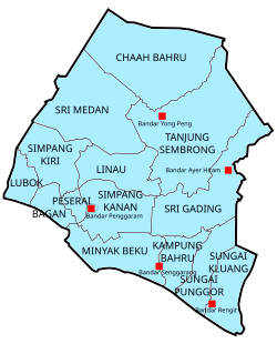
The district (daerah) is divided into fourteen mukims, each designated with a number (Mukim 1 to 12, 17, 18):

  1. Lubok (Mukim I) established 1921
  2. Bagan 峇眼 (Mukim II) established 1921
  3. Peserai (Mukim III) established 1921
  4. Simpang Kiri (Mukim IV) established 1925
  5. Simpang Kanan (Mukim V) established 1927
  6. Linau (Mukim VI) established 1935
  7. Tanjung Semberong (Mukim VII) established 1940
  8. Sri Gading (Mukim VIII) established 1942
  9. Minyak Beku 米那务固 (Mukim IX) established 1943
  10. Kampung Bahru (Mukim X) established 1946
  11. Sungai Punggor (Mukim XI) established 1949
  12. Sungai Kluang (Mukim XII) established 1952
  13. Chaah Bahru (Mukim XVII) established 1957
  14. Sri Medan 铁山 (Mukim XVIII) established 1965

Growth in small and medium industries such as textiles, garments and electronics helped to boost development, and Batu Pahat was upgraded to town status (Majlis Perbandaran) in 2001, alongside Muar, Kluang and Skudai.

Local authorities

Bandar Penggaram, Batu Pahat is administered by Batu Pahat Municipal Council which was upgraded from the previous District Council (Majlis Daerah Batu Pahat Barat) on 9 June 2001 while Yong Peng is administered by Majlis Daerah Yong Peng or Yong Peng District Council which previous named Majlis Daerah Batu Pahat Timur.

As population in Batu Pahat District is about 495k, by merging of both councils’ income, which are Majlis Perbandaran Batu Pahat (MPBP) and Majlis Daerah Yong Peng (MDYP), Batu Pahat is potential to upgrade as Majlis Bandaraya Batu Pahat (MBBP) in the coming years.

Minumum requirement eligible for a council to upgrade as City Council (Majlis Bandaraya 市政局) are:-

Towns

Demographics

Historical population
YearPop.±%
1991 294,056    
2000 336,509+14.4%
2010 401,902+19.4%
2020 495,338+23.2%
Source: [9]

The district of Batu Pahat has a population of about 398,014 local residents. [2] The population growth in 2000 was 1.55%. [10] The most populated mukim is Simpang Kanan with more than 311,862 people and the least populated is Bagan with a population of only 4,692.

The Malays are the majority (51%), while the Chinese is the largest minority (46%) and the Indian (3%).

The major religions are Islam, Buddhism, Taoism, Confucianism, Christianity and Hinduism.

Batu Pahat has more than four hundred Chinese temples due to the large Chinese population. Some of these temples are more than one century old and many have also become popular tourist attractions. Many devotees and tourists visited these temples and this has become an important part of the local economy. Chong Long Gong Temple (海口石文丁崇龙宫) was founded in 1864, is one of the popular tourist spot for devotees. A Chinese temple located at Bukit Pasir is the Kian Nam Shee Temple (建南寺). The Lim Sz Chong Su Tian Hou Temple (峇株吧辖林氏宗祠天后宫) was established in 1912 and is located in the downtown. There are also Buddhist temples or centres like Bhaddekaratta Hermitage (一夜贤者禅院), Bhavana Buddhist Society and Batu Pahat Insight Meditation Society.

There are two main mosques in Batu Pahat: Masjid Dato' Bentara Luar (located at Jalan Ampuan) and Masjid Sultan Ismail (located at Jalan Kluang)

Federal Parliament and State Assembly Seats

List of Batu Pahat district representatives in the Federal Parliament (Dewan Rakyat)

ParliamentSeat NameMember of ParliamentParty
P147 Parit Sulong Noraini AhmadBarisan Nasional (UMNO)
P148 Ayer Hitam Wee Ka SiongBarisan Nasional (MCA)
P149 Sri Gading Aminolhuda HassanPakatan Harapan (AMANAH)
P150 Batu Pahat Onn Abu BakarPakatan Harapan (PKR)

List of Batu Pahat district representatives in the State Legislative Assembly (Dewan Undangan Negeri)

ParliamentStateSeat NameState AssemblymanParty
P147N17SemerahMohd Fared Mohd KhalidBarisan Nasional (UMNO)
P147N18Sri MedanZulkarnain KamisanBarisan Nasional (UMNO)
P148N19Yong PengLing Tian SoonBarisan Nasional (MCA)
P148N20SemarangSamsol Bari JamaliBarisan Nasional (UMNO)
P149N21Parit YaaniMohd Najib SamuriBarisan Nasional (UMNO)
P149N22Parit RajaNor Rashidah RamliBarisan Nasional (UMNO)
P150N23PenggaramGan Peck ChengPakatan Harapan (DAP)
P150N24SenggarangMohd Yusla IsmailBarisan Nasional (UMNO)
P150N25RengitMohd Puad ZarkashiBarisan Nasional (UMNO)

Election results

Comparison of the parliamentary seat results in Batu Pahat district with PRU-12 (year 2008), PRU-13 (year 2013) and PRU-14 (year 2018) Batu Pahat Parliamentary seats (2008, 2013, 2018).jpg
Comparison of the parliamentary seat results in Batu Pahat district with PRU-12 (year 2008), PRU-13 (year 2013) and PRU-14 (year 2018)
Comparison of the state seat results in Batu Pahat district with PRU-12 (year 2008), PRU-13 (year 2013) and PRU-14 (year 2018) Batu Pahat State seats (2008, 2013, 2018).jpg
Comparison of the state seat results in Batu Pahat district with PRU-12 (year 2008), PRU-13 (year 2013) and PRU-14 (year 2018)

Due to electoral division by Election Commission of Malaysia, there are three parliamentary and state constituencies (DUN) dividing Batu Pahat town. There are (P147) Parit Sulong parliamentary seat, (N17) Semerah state seat; (P149) Parliament Sri Gading parliamentary seat, (N21) Parit Yanni state seat and (P150) Batu Pahat parliamentary seat, (N23) Penggaram state seat. (Election Results of the 13th Malaysian General Elections) The last election results listed as below:

P150 - Batu Pahat parliament seat

Parliament of Malaysia : P150 Batu Pahat, Johor.
YearGovernmentVotesPctOppositionVotesPctOppositionVotesPct
2018 Haji Mohd Rashid Hasnon (PH)45,92956% Haliza binti Abdullah (BN)28,03534% Dr Mahfodz (PAS)8,17310%
2013 Mohd Idris bin Jusi (PKR)38,66751% Mohd Puad Zarkashi (UMNO)36,93549%
2008 Mohd Puad Zarkashi (UMNO)32,59361%Muhammad Abdullah (PKR)19,62537%
2004 Dr Junaidy And Wahab (UMNO)38,98278%Mohamed Hanipa Maidin (PAS)9,88020%

N23 - Penggaram state seat
(Cover most of the area of Batu Pahat town)

Johor State Assembly : N23-Penggaram, Batu Pahat, Johor.
YearGovernmentVotesPctOppositionVotesPctOppositionVotesPctOppositionVotesPct
2022 Gan Peck Cheng 颜碧贞 (PH-DAP)1820853.67%Ter Hwa Kwong 戴華光 (BN-MCA)825224.32%Ronald Sia 謝委健 (PN-BERSATU)527615.55%Zahari Osman (IND)21906.46%
2018 Gan Peck Cheng 颜碧贞 (PH)26,82564.43%Kang Beng Kuan 江明光 (BN)9,62023.10%Misran bin Samian (PAS)5,18512.47%
2013 Gan Peck Cheng 颜碧贞 (DAP)24,27762%Dr. King Ban Siang 龚万祥 (MCA)14,22637%
2008 Datuk Koh Chee Chai 高志财 (MCA)12,76147% Gan Peck Cheng 颜碧贞 (DAP)12,18645%
2004 Datuk Koh Chee Chai 高志财 (MCA)16,84569% Gan Peck Cheng 颜碧贞 (DAP)6,24726%
1999 Datuk Seri Dr. Chua Soi Lek 蔡细历 (MCA)20,80974% Gan Peck Cheng 颜碧贞 (DAP)7,34926%
1995 Datuk Seri Dr. Chua Soi Lek 蔡细历 (MCA)20,17477% Gan Peck Cheng 颜碧贞 (DAP)6,13723%

P149 - Sri Gading parliamentary seat

Parliament of Malaysia : P149 Sri Gading, Batu Pahat, Johor.
YearGovernmentVotesPctOppositionVotesPctOppositionVotesPct
2018 Dr Shahruddin Salleh (PH)21,51149%AB AZIZ BIN KAPRAWI (BN)18,22341%Haji M Ashari Sidon (PAS)4,54810%
2013 AB AZIZ BIN KAPRAWI (UMNO)22,45357%MOHD KHUZZAN BIN ABU BAKAR (PKR)16,69242%
2008 Datuk Mohamad Aziz (UMNO)19,64168%Ali Markom (PKR)8,76731%
2004 Datuk Mohamad Aziz (UMNO)21,51280%Dr Ahmad Faidi Saidi (PKR)5,31620%

N21 - Parit Yanni state seat
(Part of the division in Batu Pahat town e.g.: Taman Maju, Taman Flora Utama, Parit Besar, BP Mall)

Parliament of Malaysia : N21 Parit Yanni, Batu Pahat, Johor.
YearGovernmentVotesPctOppositionVotesPctOppositionVotesPct
2018 AMINOLHUDA BIN HASSAN (PH)12,30954%Soh Lip Yan 蘇立言 (BN)7,47533%Haji Nasir (PAS)2,94313%
2013 AMINOLHUDA BIN HASSAN (PAS)11,27852%TEO YEW CHUAN 张有全 (MCA)10,09047%
2008 Ng See Tiong 黃世忠 (MCA)9,41961%Hashim Jusoh (PAS)5,56237%
2004 Ng See Tiong 黃世忠 (MCA)10,53576%Muhamad Yusof Masran (PKR)3,25924%

P147 - Parit Sulong parliamentary seat

Parliament of Malaysia : P147 Parit Sulong, Batu Pahat, Johor.
YearGovernmentVotesPctOppositionVotesPctOppositionVotesPct
2018 NORAINI BINTI AHMAD (BN)24,28149%Anis Afida (PH)18,14037%Ahmad Rosdi bin Bahari (PAS)7,14814%
2013 NORAINI BINTI AHMAD (UMNO)30,25861%KHAIRUDDIN BIN A RAHIM (PAS)18,50538%
2008 NORAINI BINTI AHMAD (UMNO)26,06666%Faisal Ali (PAS)12,46732%
2004 NORAINI BINTI AHMAD (UMNO)26,97471%Suhaizan Kaiat (PAS)9,78824%

N17 - Semerah state seat
(Part of the division in Batu Pahat town e.g.: Taman Pantai, Jalan Syahbandar, Jalan Rugayah)

Parliament of Malaysia : N17 Semerah, Batu Pahat, Johor.
YearGovernmentVotesPctOppositionVotesPctOppositionVotesPct
2018 Khuzzan Abu Bakar (PH)12,61942.85%MOHD ISMAIL BIN ROSLAN (BN)12,52142.51%Ustaz Wan (PAS)4,31414.64%
2013 MOHD ISMAIL BIN ROSLAN (UMNO)14,40455%MD YSAHRUDIN BIN KUSNI (PKR)11,75545%
2008 Datuk Ariss Samsudin (UMNO)13,15661%Muhamad Hasmi Hashim (PKR)8,08238%
2004 Datuk Ariss Samsudin (UMNO)15,71574%Mazlan Aliman (PAS)5,04624%

Economy

The main economy activities in the district are furniture manufacturing, food processing and agritourism. [11] Main industrial towns in the district are Ayer Hitam, Batu Pahat Town, Pekan Sri Wangi, Parit Sulong and Yong Peng. As of 2010, the per capita income was MYR14,122. [10] Local " pasar malam " or night markets are held in residential areas with petty traders setting up stalls and selling a variety of food and daily necessities at bargain prices.

Education

In Batu Pahat, there are 24 national secondary schools, 3 independent Chinese secondary schools and a vocational school. Among some of the best secondary schools in Batu Pahat are:

Notable people

Related Research Articles

<span class="mw-page-title-main">Kluang District</span> District of Malaysia in Johor

The Kluang District is a district in Johor, Malaysia. Its district capital is Kluang Town. Kluang district is one of the three landlocked districts in Johor, the other being Segamat and Kulai.

<span class="mw-page-title-main">Segamat District</span> District in Johor, Malaysia

The Segamat District or simply Segamat is a district in the Malaysian state of Johor. Segamat is also the name of the district's primary town.

<span class="mw-page-title-main">Mersing</span> Town and district capital in Johor, Malaysia

Mersing is a town, mukim and the capital of Mersing District, Johor, Malaysia.

<span class="mw-page-title-main">Yong Peng</span> Township in Johor, Malaysia

Yong Peng is a town in Mukim Tanjung Semberong, Batu Pahat District, Johor, Malaysia. It has an area of 1911.6 hectares with an estimated population of 29,046.

<span class="mw-page-title-main">Rengit</span> Town and sub-district in Johor, Malaysia

Rengit is a town and an autonomous sub-district in Mukim Sungai Kluang, Batu Pahat District, Johor, Malaysia. Rengit has more than 30 villages and 25 schools.

<span class="mw-page-title-main">Parit Raja</span> Township in Johor, Malaysia

Parit Raja is a town in Batu Pahat District, Johor, Malaysia. The main population of this town and its surrounding areas has been resided by Malay with Javanese descent, besides the Chinese population. This locality has a unique diversification spanning from foods and cultures. There is lots of restaurant that serves Indian Muslim, Chinese, Southern Malay and Northern Malay cuisines. This locality also being as an important marketplace, few examples are, Pasar Isnin-Khamis, Pasar Rabu, making it a hotspot for local farmers, street food hawkers and commercial businesses. In recent years, the town has seen substantial growth due to the rapid expansion of Universiti Tun Hussein Onn Malaysia (UTHM) and a few other higher education campuses. Because of that, Parit Raja observes a rapid growth in economic and social quality. Parit Raja also has been entitled as an education hub for the southern state of Johor

<span class="mw-page-title-main">Batu Pahat River</span> River in Pantai Minyak Beku, Batu Pahat

The Batu Pahat River is the river originating from Sungai Simpang Kiri and Sungai Simpang Kanan near Tongkang Pechah, and flows through Batu Pahat and until it reaches the mouth of the river in Pantai Minyak Beku, a seaside village lying on the west coast of Johor, Malaysia.

<span class="mw-page-title-main">Minyak Beku</span>

Minyak Beku is a mukim in Batu Pahat District, Johor, Malaysia.

<span class="mw-page-title-main">Sri Gading</span> Suburb of Batu Pahat in Johor, Malaysia

Sri Gading or Seri Gading is a mukim and parliamentary constituency in Batu Pahat District, Johor, Malaysia, located along Jalan Batu Pahat-Kluang. It lies south-east of Batu Pahat town, north-west of Ayer Hitam and west of Yong Peng. It is also a name of one of 14 parishes in Johor.

<span class="mw-page-title-main">Taman Flora Utama</span>

Taman Flora Utama is a township in Bandar Penggaram, Batu Pahat, Johor, Malaysia. It was constructed in 2005. Taman Flora Utama is located beside Jalan Tan Siew Hoe. The new township is developing rapidly. This township is mainly for shopping, leisure and commercial activities.

Taman Bukit Pasir is a township in Bandar Penggaram, Batu Pahat, Johor, Malaysia. This township is mainly for finance, banking, and commercial activities. Development of the township began in the early 1990s. Taman Bukit Pasir is located along Jalan Bukit Pasir and Jalan Tan Siew Hoe. The township is developing rapidly. There are many shophouses and houses in this township. A shopping area, Wira Court, is also located in this township.

<span class="mw-page-title-main">Batu Pahat Municipal Council</span>

Batu Pahat Municipal Council is a local authority which administrates West Batu Pahat District in Johor, Malaysia. This agency is under Johor state government. MPBP are responsible for public health and sanitation, waste removal and management, town planning, environmental protection and building control, social and economic development and general maintenance functions of urban infrastructure. The MPBP main headquarters is located at Jalan Pejabat, Bandar Penggaram, Batu Pahat.

Segenting is a small town in Minyak Beku, Batu Pahat District, Johor, Malaysia. It is about 8 km away from Bandar Penggaram, Batu Pahat, capital of Batu Pahat district.

<span class="mw-page-title-main">Linau, Johor</span> Parish / Mukim in Johor, Malaysia

Linau Mukim is a mukim located in Batu Pahat district in Johor. Batu Pahat district is divided into 14 parishes, each of which encompasses several villages.

<span class="mw-page-title-main">Kampung Bahru</span> Mukim in Johor, Malaysia

Mukim Kampung Bahru or Kampong Bahru is a mukim located in Batu Pahat District in Johor, Malaysia. Batu Pahat District was divided into 14 mukims, each of which encompasses several villages. The population was 11,997 in 2010. The majority ethics of the population in the Kampung Bahru is Malay (9,286).

<span class="mw-page-title-main">Sungai Kluang</span> Mukim in Johor, Malaysia

Mukim Sungai Kluang or Sungai Keluang is a mukim located in Batu Pahat District in Johor, Malaysia. Batu Pahat District was divided into 14 mukims, each of which encompasses several villages. The population was 16,591 in 2010. The majority ethics of the population in the Sungai Kluang is Malay (11,854). It border with Mukim Benut, Pontian District in east and Mukim Sungai Punggor in west.

<span class="mw-page-title-main">Chaah Bahru</span> Mukim in Batu Pahat, Johor, Malaysia

Chaah Bahru is a mukim in Batu Pahat District, Johor, Malaysia.

References

  1. "Profil Daerah". ptj.johor.gov.my. Archived from the original on 15 April 2021. Retrieved 26 December 2017.
  2. 1 2 "Population Distribution and Basic Demographic Characteristics, 2010" (PDF). Department of Statistics, Malaysia. Archived from the original (PDF) on 22 May 2014. Retrieved 19 April 2012.
  3. Perpustakaan Negara Malaysia Website
  4. "83000 batu pahat, johor » Interesting BP Info". Archived from the original on 5 May 2007. Retrieved 13 June 2007.
  5. Perpustakaan Negara Malaysia Website "Sejarah Malaysia". Archived from the original on 13 April 2006. Retrieved 14 April 2006.
  6. "YouTube". www.youtube.com.
  7. Webmaster, MT (31 March 2014). "Malaysians mudah lupa – Malaysia Today". www.malaysia-today.net. Retrieved 16 October 2018.
  8. "Portal Rasmi Majlis Perbandaran Batu Pahat (MPBP)". Portal Rasmi Majlis Perbandaran Batu Pahat (MPBP). Retrieved 19 August 2023.
  9. "Key Findings of Population and Housing Census of Malaysia 2020" (pdf) (in Malay and English). Department of Statistics, Malaysia. ISBN   978-967-2000-85-3.
  10. 1 2 Handbook gov.my
  11. "Muafakat ke Arah #Johor Berkemajuan" (PDF). Muafakat Johor (in Malay). Retrieved 17 March 2018.