Kuala Terengganu District

Last updated
Kuala Terengganu District
Daerah Kuala Terengganu
Other transcription(s)
   Jawi كوالا ترڠڬانو
   Chinese 瓜拉登嘉楼县
Flag of Kuala Terengganu, Terengganu.svg
TG-District-KTrg.jpg
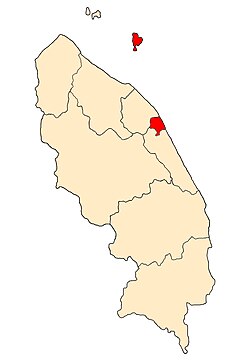
Location of Kuala Terengganu District in Terengganu
Kuala Terengganu District
Malaysia location map with districts.svg
Red pog.svg
Kuala Terengganu District
Location of Kuala Terengganu District in Malaysia
Coordinates: 5°20′N103°10′E / 5.333°N 103.167°E / 5.333; 103.167
Country Flag of Malaysia.svg  Malaysia
State Flag of Terengganu.svg  Terengganu
Seat Kuala Terengganu
Local area government(s) Kuala Terengganu City Council
Government
  District officerAzmi Razik
Area
[1]
  Total210.21 km2 (81.16 sq mi)
Population
 (2010) [2] (Contain Kuala Nerus District)
  Total343,284
  Estimate 
(2014) [3]
184,600
  Density1,600/km2 (4,200/sq mi)
Time zone UTC+8 (MST)
  Summer (DST) UTC+8 (Not observed)
Postcode
21xxx
Calling code +6-09-6
Vehicle registration plates T

The Kuala Terengganu District is a district in the state of Terengganu, Malaysia. It covers an area of 210.21 square kilometres, and had a population of 343,284 at the 2010 Census . [2] The district is bordered by Terengganu River which separates Kuala Nerus District in the north and west, Marang District in the south and South China Sea in the east. The capital of this district is Kuala Terengganu.

Contents

Administrative divisions

Map of Kuala Terengganu District, Terengganu.svg

Kuala Terengganu District is divided into 20 mukims/sub-districts, which are:

Demographics

Historical population
YearPop.±%
1991 274,489    
2000 298,304+8.7%
2010 337,553+13.2%
2020 229,780−31.9%
Figures before 2014 includes Kuala Nerus District.
Source: [4]

Federal Parliament and State Assembly Seats


List of Kuala Terengganu district representatives in the Federal Parliament (Dewan Rakyat)

ParliamentSeat NameMember of ParliamentParty
P36 Kuala Terengganu Ahmad Amzad Hashim PN ( PAS )


List of Kuala Terengganu district representatives in the State Legislative Assembly of Terengganu

ParliamentStateSeat NameState AssemblymanParty
P36N13 Wakaf Mempelam Wan Sukairi Wan Abdullah PN ( PAS )
P36N14 Bandar Ahmad Shah Muhamed PN ( PAS )
P36N15 Ladang Tengku Hassan Tengku Omar PN ( PAS )
P36N16 Batu Buruk Muhammad Khalil Abdul Hadi PN ( PAS )

See also

Related Research Articles

<span class="mw-page-title-main">Terengganu</span> State of Malaysia

Terengganu, formerly spelled Trengganu or Tringganu, is a sultanate and constitutive state of federal Malaysia. The state is also known by its Arabic honorific, Dāru l-Īmān. The coastal city of Kuala Terengganu, which stands at the mouth of the broad Terengganu River, is both the state and royal capital as well as the largest city in Terengganu. There are many islands located close to the coast of Terengganu state, such as Perhentian Islands and Redang Island.

<span class="mw-page-title-main">Kuala Terengganu</span> City in Terengganu, Malaysia

Kuala Terengganu, colloquially referred to as KT, is the administrative, economic and royal capital of the state of Terengganu, Malaysia. Kuala Terengganu is also the capital of Kuala Terengganu District. It is also the only royal capital among the nine royal states of the country to bear its state's name. Kuala Terengganu is located about 440 kilometres northeast of Kuala Lumpur on the East Coast of Peninsular Malaysia. The city is situated at the estuary of Terengganu River, facing the South China Sea.

<span class="mw-page-title-main">Dungun District</span> District of Malaysia

Dungun is a coastal district of the Malaysian state of Terengganu. Kuala Dungun is the capital of the district. Dungun is made up of eleven 'mukim', or subdistricts: Abang, Besol, Jengai, Jerangau, Kuala Dungun, Kuala Paka, Kumpal, Pasir Raja, Rasau, Sura, and Hulu Paka.

<span class="mw-page-title-main">Hulu Perak District</span> District of Malaysia in Perak

Hulu Perak District is a district in Perak, Malaysia. As the largest district in Perak, there are border to the east of the district is the state of Kelantan, to the west is Kedah, to the south is the district of Kuala Kangsar while to the south-west is the district of Larut, Matang and Selama. Hulu Perak also shares a border with Betong District of Thailand. The seat of the district is Gerik, which is also the largest town of the district.

<span class="mw-page-title-main">Perak Tengah District</span> District of Malaysia in Perak

Perak Tengah District is a district in Perak, Malaysia. It is administered by the Perak Tengah District Council, which is based at the town of Seri Iskandar; Parit is however the largest settlement in the area.

<span class="mw-page-title-main">Sabak Bernam District</span> District of Malaysia in Selangor

The Sabak Bernam District is a district and a parliamentary constituency in north-western Selangor, Malaysia. It covers an area of 997 square kilometres, and had a population of 103,153 at the 2010 Census. It is situated at the northwestern corner of Selangor. It is bordered by the state of Perak to the north, the district of Hulu Selangor to the east, the district of Kuala Selangor to the south, and the Straits of Malacca to the west. Bernam River forms its border with Perak. Towns in Sabak Bernam include Sabak, Sungai Besar and Sekinchan. This area is also famous for its residents of Javanese descent.

<span class="mw-page-title-main">Kemaman District</span> District of Malaysia in Terengganu

Kemaman is a district in Terengganu, Malaysia. Kemaman District is bordered by Dungun District to the north and the state of Pahang to the south and west. It is the southern gateway to the state of Terengganu.

<span class="mw-page-title-main">Alor Gajah District</span> District in Malacca, Malaysia

Alor Gajah District is one of the three administrative districts in Malacca, Malaysia. It borders Tampin District, Rembau District and Port Dickson District in Negeri Sembilan to the north and borders Jasin District and Melaka Tengah District in the east and south respectively.

<span class="mw-page-title-main">Jerantut District</span> District of Malaysia in Pahang

The Jerantut District is a district in north-eastern Pahang, Malaysia. Jerantut is home to the National Park.

<span class="mw-page-title-main">Rompin District</span> District of Malaysia in Pahang

The Rompin District is a district located in the southeastern corner of Pahang, Malaysia. Rompin is currently under the Rompin District Council.

<span class="mw-page-title-main">Hulu Terengganu District</span> District of Malaysia in Terengganu

Hulu Terengganu is an interior district of Terengganu, Malaysia. The seat of the district is Kuala Berang, located about 40 km (25 mi) from the state capital, Kuala Terengganu. The local government of this district is Hulu Terengganu District Council.

<span class="mw-page-title-main">Besut District</span> District of Malaysia in Terengganu

Besut is a district in Terengganu, Malaysia. It is bordered by the state of Kelantan to the north and west and the South China Sea to the east. It is the northern gateway to Terengganu. Kampung Raja is the district capital, though Jerteh is more developed. Another major town is the fishing port of Kuala Besut. There are other small towns and villages such as Jabi, Apal, Pasir Akar and Tembila.

<span class="mw-page-title-main">Setiu District</span> District of Malaysia in Terengganu

Setiu is one of the districts in Terengganu, Malaysia. This district is bordered by Besut to the north, Hulu Terengganu to the south, and on the east, Kuala Nerus District.

<span class="mw-page-title-main">Larut, Matang and Selama District</span> District of Malaysia in Perak

The Larut, Matang and Selama District is a district of Perak, Malaysia. Taiping is the capital town of this district. Larut, Matang and Selama used to be three small different districts and they merged into one larger district later. Larut, Matang and Selama houses Taiping, Perak's second largest city and former state capital. Other towns in the region include Matang, Kuala Sepetang and Selama. The region borders the state of Kedah on the north, the Kerian District on the northwest, the Hulu Perak and Kuala Kangsar District on the east, and the Manjung District on the south.

<span class="mw-page-title-main">Marang District</span> District of Malaysia in Terengganu

The Marang District is a coastal district in Terengganu, Malaysia. The district seat is the town of Marang. The districts that border Marang are Kuala Terengganu and Kuala Nerus to the north, Hulu Terengganu in the west, while Dungun is in the south. The eastern part of the district is a stretch of coastline facing the South China Sea.

<span class="mw-page-title-main">Kuala Nerus District</span> District of Malaysia in Terengganu

Kuala Nerus is a district in Terengganu, Malaysia. It is the youngest district in the state, having been declared a separate district in 2014. Formerly it was part of Kuala Terengganu district but the district is still governed by Kuala Terengganu City Council (MBKT) which is one of few city councils in Malaysia to govern two separate districts. Its capital is Kuala Nerus town, other major towns and villages include Gong Badak, Seberang Takir, Batu Rakit and Batu Enam, all which are located within city limits of Kuala Terengganu. Kuala Nerus' population is 226,177 people as of 2015 which makes it the most populous district in Terengganu. The district has a total land area of 397.52 km2.

<span class="mw-page-title-main">Kuantan District</span> District of Malaysia in Pahang

The Kuantan District is a district in Pahang, Malaysia. Located in the north-east of Pahang, the district bordered Kemaman District of Terengganu on the north, South China Sea on the east, Jerantut District and Maran District on the west and Pekan District on the south.

<span class="mw-page-title-main">Pekan District</span> District of Malaysia in Pahang

The Pekan District is a district in Pahang, Malaysia. Located in the east of Pahang, the district borders Kuantan District on the north, South China Sea on the east, Maran District on the west and Rompin District on the south.

<span class="mw-page-title-main">Kuala Kangsar District</span> District in Perak, Malaysia

The Kuala Kangsar District is a district in Perak, Malaysia. Kuala Kangsar shares its borders with Larut, Matang and Selama at the west, Hulu Perak at the north, Gua Musang of Kelantan at the east, Kinta at the south, Perak Tengah and Manjung at the southwest. The seat of this district is the town of Kuala Kangsar.

References

  1. Administrator. "Laman Web Rasmi Pejabat Daerah Dan Tanah Kuala Nerus". pdtknerus.terengganu.gov.my. Archived from the original on 2021-01-20. Retrieved 2017-12-25.
  2. 1 2 "Population Distribution and Basic Demographic Characteristics, 2010" (PDF). Department of Statistics, Malaysia. Archived from the original (PDF) on 22 May 2014. Retrieved 19 April 2012.
  3. Administrator. "Pengenalan Daerah Dungun". pdtdungun.terengganu.gov.my.
  4. "Key Findings Population and Housing Census of Malaysia, 2020" (in Malay and English). Department of Statistics, Malaysia.